Tocht Fiets Saône - Les Forts de Besançon - Photo
 tracegps
tracegps

Gebruiker

© OpenStreetMap contributors
Lengte
Lengte
84 km
Max. hoogte
Max. hoogte
605 m
Positief hoogteverschil
2012 m
Km-Effort
Km-Effort  
111 km
Min. hoogte
Min. hoogte
237 m
Negatief hoogteverschil
2012 m
Boucle
Boucle
Ja
Datum van aanmaak :
2014-12-10 00:00:00.0
Laatste wijziging :
2014-12-10 00:00:00.0

(0 Bericht)

Fiets
Fiets
4h30
Moeilijkheid : Moeilijk

Scan deze QR-code om de tocht te openen in de SityTrail-applicatie

Gratisgps-wandelapplicatie

Logo SityTrail SityTrail

IGN / Geografische instituten

SityTrail uit de App Store downloaden SityTrail uit Google Play downloaden

Logo SityTrail SityTrail World

De wereld gaat voor u open

SityTrail uit de App Store downloaden SityTrail uit Google Play downloaden SityTrail op Huawei AppGallery downloaden

Over ons

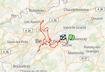
Tocht Fiets van 84 km beschikbaar op Bourgondië-Franche-Comté, Doubs, Saône. Deze tocht wordt voorgesteld door tracegps.

Beschrijving

Circuit difficile, au niveau de la batterie des Epesses le revêtement n'est pas de bonne qualité. Au niveau du fort de Rosemont on ne peut pas monter jusqu'au sommet sauf en VTT. Mon GPS n'ayant pas fonctionné normalement le jour de la sortie, j'ai fait une transcription à l'aide des cartes IGN.

Hoogteprofiel

Foto's

Plaatsbepaling

Land:
France
Regio :
Bourgondië-Franche-Comté
Departement/Provincie :
Doubs
Gemeente :
Saône
Locatie:
Unknown
Vertrek:(Dec)
Vertrek:(UTM)
281909 ; 5234629 (32T) N.

Wandeltochten in de omgeving

Tocht Stappen Montfaucon - Du chateau au fort de Monfaucon - Photo
Stappen
yew

Stappen

Gemakkelijk
(1)
Montfaucon, Bourgondië-Franche-Comté, Doubs, France
6,9 km | 9,3 km-effort
1h 55min
Ja
Tocht Te voet Mamirolle - Sentier du Bois de la Fougère - Photo
Te voet
GUIDE+

Te voet

Gemakkelijk
Mamirolle, Bourgondië-Franche-Comté, Doubs, France
7,3 km | 8,7 km-effort
1h 58min
Ja
Tocht Te voet Nancray - Circuit du Chêne Président - Photo
Te voet
GUIDE+

Te voet

Gemakkelijk
Nancray, Bourgondië-Franche-Comté, Doubs, France
6,4 km | 7,2 km-effort
1h 38min
Ja
Tocht Te voet Montfaucon - Boucle de Nacra - Photo
Te voet
GUIDE+

Te voet

Gemakkelijk
Montfaucon, Bourgondië-Franche-Comté, Doubs, France
3 km | 4,4 km-effort
1h 0min
Ja
Tocht Te voet Saône - Sentier des Essarts - Photo
Te voet
GUIDE+

Te voet

Gemakkelijk
Saône, Bourgondië-Franche-Comté, Doubs, France
6,9 km | 8,1 km-effort
1h 50min
Ja
Tocht Te voet Montfaucon - Sentier des Falaises et du château - Photo
Te voet
GUIDE+

Te voet

Gemakkelijk
Montfaucon, Bourgondië-Franche-Comté, Doubs, France
5 km | 7,1 km-effort
1h 37min
Ja
Tocht Te voet Nancray - Sentier du Fonteny - Photo
Te voet
GUIDE+

Te voet

Gemakkelijk
Nancray, Bourgondië-Franche-Comté, Doubs, France
7,4 km | 9 km-effort
2h 2min
Ja
Tocht Te voet Montfaucon - Sentier du Fort et des Batteries - Photo
Te voet
GUIDE+

Te voet

Gemakkelijk
Montfaucon, Bourgondië-Franche-Comté, Doubs, France
6,6 km | 8,7 km-effort
1h 58min
Ja
Tocht Te voet Mamirolle - Sentier du Golf - Photo
Te voet
GUIDE+

Te voet

Gemakkelijk
Mamirolle, Bourgondië-Franche-Comté, Doubs, France
8,7 km | 10,4 km-effort
2h 21min
Ja


Sluiten
Mijn abonnementen