Tocht Stappen Saint-Zacharie - Rando St Zacharie Pas de Peyruis  - Photo

Rando St Zacharie Pas de Peyruis

 tracegps
tracegps

Gebruiker

© OpenStreetMap contributors
Lengte
Lengte
12,5 km
Max. hoogte
Max. hoogte
639 m
Positief hoogteverschil
393 m
Km-Effort
Km-Effort  
17,7 km
Min. hoogte
Min. hoogte
299 m
Negatief hoogteverschil
396 m
Boucle
Boucle
Ja
Datum van aanmaak :
2014-12-10 00:00:00.0
Laatste wijziging :
2014-12-10 00:00:00.0

(0 Bericht)

Stappen
Stappen
4h00
Moeilijkheid : Medium

Scan deze QR-code om de tocht te openen in de SityTrail-applicatie

Gratisgps-wandelapplicatie

Logo SityTrail SityTrail

IGN / Geografische instituten

SityTrail uit de App Store downloaden SityTrail uit Google Play downloaden

Logo SityTrail SityTrail World

De wereld gaat voor u open

SityTrail uit de App Store downloaden SityTrail uit Google Play downloaden SityTrail op Huawei AppGallery downloaden

Over ons

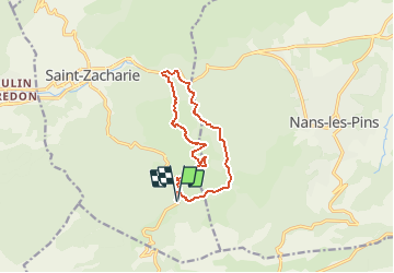
Tocht Stappen van 12,5 km beschikbaar op Provence-Alpes-Côte d'Azur, Var, Saint-Zacharie. Deze tocht wordt voorgesteld door tracegps.

Beschrijving

Pas de difficulté particulière niveau 3. Trois ou quatre passages à gué. Vue panoramique au niveau de l'alti surface sur Auriol, Sainte Zacharie, Nans les Pins, Plan d'Aups, les montagnes de la Ste Baume et de la Sainte Victoire par temps clair sur le mont Ventoux. D’autres informations sur le site de Rando Loisirs à Carnoux en Provence.

Hoogteprofiel

Foto's

Plaatsbepaling

Land:
France
Regio :
Provence-Alpes-Côte d'Azur
Departement/Provincie :
Var
Gemeente :
Saint-Zacharie
Locatie:
Unknown
Vertrek:(Dec)
Vertrek:(UTM)
721628 ; 4803845 (31T) N.

Wandeltochten in de omgeving

Tocht Stappen Plan-d'Aups-Sainte-Baume - Sainte Baume 8,5 km - Photo
Stappen
GUIDE
rvapeldo

Stappen

Medium
(1)
Plan-d'Aups-Sainte-Baume, Provence-Alpes-Côte d'Azur, Var, France
8,4 km | 15,5 km-effort
4h 38min
Ja
Tocht Stappen Plan-d'Aups-Sainte-Baume - SityTrail - Sentier merveilleux - La Ste baume - Le Plan d'aups  - Photo
Stappen
GUIDE
affinetataille

Stappen

Medium
(1)
Plan-d'Aups-Sainte-Baume, Provence-Alpes-Côte d'Azur, Var, France
15 km | 23 km-effort
6h 0min
Ja
Tocht Stappen Plan-d'Aups-Sainte-Baume - Crêts de la Ste Baume - Photo
Stappen
tracegps

Stappen

Medium
(2)
Plan-d'Aups-Sainte-Baume, Provence-Alpes-Côte d'Azur, Var, France
15,4 km | 23 km-effort
5h 0min
Ja
Tocht Stappen Plan-d'Aups-Sainte-Baume - Du Col du Saint-Pilon au Pas de l'Aï, Sainte Baume - Photo
Stappen
tracegps

Stappen

Medium
(1)
Plan-d'Aups-Sainte-Baume, Provence-Alpes-Côte d'Azur, Var, France
13,1 km | 20 km-effort
5h 15min
Ja
Tocht Stappen Plan-d'Aups-Sainte-Baume - La Grotte aux oiseaux - Plan d'Aups  - Photo
Stappen
tracegps

Stappen

Medium
(1)
Plan-d'Aups-Sainte-Baume, Provence-Alpes-Côte d'Azur, Var, France
8,8 km | 12,5 km-effort
2h 30min
Ja
Tocht Te voet Plan-d'Aups-Sainte-Baume - Massif Sainte Baume et pas de l’Aï 15 km - Photo
Te voet
GUIDE
rvapeldo

Te voet

Medium
Plan-d'Aups-Sainte-Baume, Provence-Alpes-Côte d'Azur, Var, France
15 km | 22 km-effort
5h 0min
Ja
Tocht Stappen Plan-d'Aups-Sainte-Baume - Sainte Baume par le sentier Marcel d'Estruch - Photo
Stappen
GUIDE
nadd73

Stappen

Moeilijk
Plan-d'Aups-Sainte-Baume, Provence-Alpes-Côte d'Azur, Var, France
13,3 km | 23 km-effort
4h 40min
Neen
Tocht Stappen Plan-d'Aups-Sainte-Baume - Marcel estruche - Photo
Stappen
GUIDE
Danielba

Stappen

Moeilijk
Plan-d'Aups-Sainte-Baume, Provence-Alpes-Côte d'Azur, Var, France
10,4 km | 18,9 km-effort
8h 6min
Neen
Tocht Stappen Plan-d'Aups-Sainte-Baume - Pic de Bertagne - Grotte Betton - Le plan d'aups - Photo
Stappen
GUIDE
affinetataille

Stappen

Medium
Plan-d'Aups-Sainte-Baume, Provence-Alpes-Côte d'Azur, Var, France
9,9 km | 15,7 km-effort
3h 30min
Ja


Sluiten
Mijn abonnementen