![](/images/other/stat-length.png)
![Tocht Stappen Landéda - AberWrac'h - Traon Bizin - 4km - Photo](https://media.geolcdn.com/t/1900/400/ext.pjpeg?maxdim=2&url=https%3A%2F%2Fstatic1.geolcdn.com%2Fsiteimages%2Fupload%2Ffiles%2F1553511878bg_sport_marche.png)
AberWrac'h - Traon Bizin - 4km
tracegps
Gebruiker
![Lengte](/images/other/stat-length.png)
Lengte
4,1 km
![Max. hoogte](https://static1.geolcdn.com/siteimages/upload/files/1508320355ic_sort_altitude_max_24dp.png)
Max. hoogte
35 m
![Positief hoogteverschil](https://static1.geolcdn.com/siteimages/upload/files/1508320355ic_sort_den_pos_24dp.png)
Positief hoogteverschil
71 m
![Km-Effort](/images/other/stat-length.png)
Km-Effort
5 km
![Min. hoogte](https://static1.geolcdn.com/siteimages/upload/files/1508320355ic_sort_altitude_min_24dp.png)
Min. hoogte
-3 m
![Negatief hoogteverschil](https://static1.geolcdn.com/siteimages/upload/files/1508320355ic_sort_den_neg_24dp.png)
Negatief hoogteverschil
73 m
![Boucle](https://static1.geolcdn.com/siteimages/upload/files/16400158638029165_repeat_loop_refresh_sync_direction_icon.png)
Boucle
Ja
Datum van aanmaak :
2014-12-10 00:00:00.0
Laatste wijziging :
2014-12-10 00:00:00.0
![Stappen](https://static1.geolcdn.com/sitytour/trail-icons/101.png)
1h00
Moeilijkheid : Medium
![Scan deze QR-code om de tocht te openen in de SityTrail-applicatie](https://capi.geolives.com/qq0zvz2zws4bq2lad0pu/sitytour/trails/104028/qr.png?size=200)
Gratisgps-wandelapplicatie
Over ons
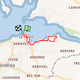
Tocht Stappen van 4,1 km beschikbaar op Bretagne, Finistère, Landéda. Deze tocht wordt voorgesteld door tracegps.
Beschrijving
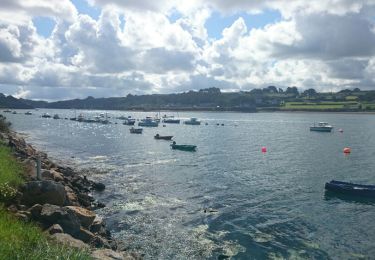
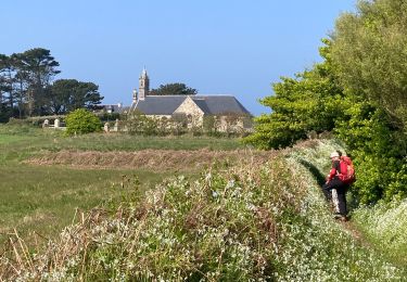
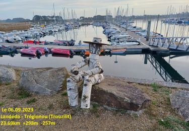
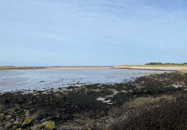
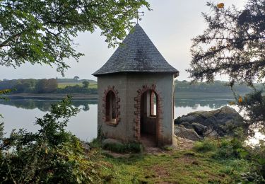
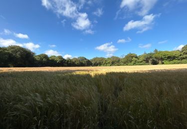
Randonnée pédestre au départ du centre UCPA , pour longer une partie de l'Aber par les petits sentiers du littoral. Retour au milieu des fougères. Panorama très celtique.
Plaatsbepaling
Land:
France
Regio :
Bretagne
Departement/Provincie :
Finistère
Gemeente :
Landéda
Locatie:
Unknown
Vertrek:(Dec)
Vertrek:(UTM)
384834 ; 5383924 (30U) N.
Opmerkingen
Wandeltochten in de omgeving
![Tocht Stappen Plouguerneau - Boucle Lilia - Perros - Photo](https://media.geolcdn.com/t/375/260/ext.jpg?maxdim=2&url=https%3A%2F%2Fservices.sitytrail.com%2FGeolivesWS%2FDownloadMedia.ashx%3FTrailID%3D462854%26Media%3Dfix__20150823120806.jpg)
![Stappen Stappen](https://static1.geolcdn.com/sitytour/trail-icons/101.png)
Boucle Lilia - Perros
Stappen
Gemakkelijk
(2)
Plouguerneau,
Bretagne,
Finistère,
France
![](/images/other/stat-length.png)
9,7 km | 10,8 km-effort
2h 10min
![](https://static1.geolcdn.com/siteimages/upload/files/16400158638029165_repeat_loop_refresh_sync_direction_icon.png)
Ja
![Tocht Stappen Plouguerneau - La tête de l'île - Photo](https://media.geolcdn.com/t/375/260/b43884a9-7f38-4fbc-8e53-86aa4116e8f9.jpg&format=jpg&maxdim=2)
![Stappen Stappen](https://static1.geolcdn.com/sitytour/trail-icons/101.png)
La tête de l'île
Stappen
Gemakkelijk
(1)
Plouguerneau,
Bretagne,
Finistère,
France
![](/images/other/stat-length.png)
6,1 km | 6,7 km-effort
1h 52min
![](https://static1.geolcdn.com/siteimages/upload/files/16400158638029165_repeat_loop_refresh_sync_direction_icon.png)
Ja
![Tocht Stappen Landéda - 06.09.24 Landéda -- Treglonou (Touzilit) - Photo](https://media.geolcdn.com/t/375/260/ec11815a-c8fb-467a-9689-1ba3e69aa97c.jpg&format=jpg&maxdim=2)
![Stappen Stappen](https://static1.geolcdn.com/sitytour/trail-icons/101.png)
06.09.24 Landéda -- Treglonou (Touzilit)
Stappen
Zeer moeilijk
Landéda,
Bretagne,
Finistère,
France
![](/images/other/stat-length.png)
24 km | 28 km-effort
6h 15min
![](https://static1.geolcdn.com/siteimages/upload/files/16400158638029165_repeat_loop_refresh_sync_direction_icon.png)
Neen
![Tocht Stappen Plouguerneau - 05.09.23 Lilia -- Landéda - Photo](https://media.geolcdn.com/t/375/260/c7c06625-49c8-4c0c-abbd-b4fc835862db.jpg&format=jpg&maxdim=2)
![Stappen Stappen](https://static1.geolcdn.com/sitytour/trail-icons/101.png)
05.09.23 Lilia -- Landéda
Stappen
Zeer moeilijk
Plouguerneau,
Bretagne,
Finistère,
France
![](/images/other/stat-length.png)
17,1 km | 21 km-effort
4h 43min
![](https://static1.geolcdn.com/siteimages/upload/files/16400158638029165_repeat_loop_refresh_sync_direction_icon.png)
Neen
![Tocht Fietstoerisme Plouguerneau - St Michel à St Pabu - Photo](https://media.geolcdn.com/t/375/260/20ce82cb-3f5c-494c-b024-433b8cba4612.jpg&format=jpg&maxdim=2)
![Fietstoerisme Fietstoerisme](https://static1.geolcdn.com/sitytour/trail-icons/204.png)
St Michel à St Pabu
Fietstoerisme
Medium
Plouguerneau,
Bretagne,
Finistère,
France
![](/images/other/stat-length.png)
55 km | 63 km-effort
5h 2min
![](https://static1.geolcdn.com/siteimages/upload/files/16400158638029165_repeat_loop_refresh_sync_direction_icon.png)
Neen
![Tocht Stappen Landéda - Aberwac’h la dune (boucle) - Photo](https://media.geolcdn.com/t/375/260/e7189307-e1c4-4d36-a21c-92827b960ec1.jpg&format=jpg&maxdim=2)
![Stappen Stappen](https://static1.geolcdn.com/sitytour/trail-icons/101.png)
Aberwac’h la dune (boucle)
Stappen
Gemakkelijk
Landéda,
Bretagne,
Finistère,
France
![](/images/other/stat-length.png)
15,3 km | 17,3 km-effort
3h 49min
![](https://static1.geolcdn.com/siteimages/upload/files/16400158638029165_repeat_loop_refresh_sync_direction_icon.png)
Ja
![Tocht Te voet Landéda - Penn Enez ter - Photo](https://media.geolcdn.com/t/375/260/ext.jpg?maxdim=2&url=https%3A%2F%2Fstatic1.geolcdn.com%2Fsiteimages%2Fupload%2Ffiles%2F1545311037marcheuse_200dpi.jpg)
![Te voet Te voet](https://static1.geolcdn.com/sitytour/trail-icons/100.png)
Penn Enez ter
Te voet
Gemakkelijk
(1)
Landéda,
Bretagne,
Finistère,
France
![](/images/other/stat-length.png)
3,2 km | 3,4 km-effort
47min
![](https://static1.geolcdn.com/siteimages/upload/files/16400158638029165_repeat_loop_refresh_sync_direction_icon.png)
Ja
![Tocht Stappen Tréglonou - 07.09.23 Trouzilit -- Ploudalmézeau - Photo](https://media.geolcdn.com/t/375/260/4d914aa5-6c40-441a-82d6-52fface3f0bb.jpg&format=jpg&maxdim=2)
![Stappen Stappen](https://static1.geolcdn.com/sitytour/trail-icons/101.png)
07.09.23 Trouzilit -- Ploudalmézeau
Stappen
Zeer moeilijk
Tréglonou,
Bretagne,
Finistère,
France
![](/images/other/stat-length.png)
23 km | 27 km-effort
6h 5min
![](https://static1.geolcdn.com/siteimages/upload/files/16400158638029165_repeat_loop_refresh_sync_direction_icon.png)
Neen
![Tocht sport Saint-Pabu - Évite - Photo](https://media.geolcdn.com/t/375/260/101fdcc4-fb1b-4fe5-9c4a-e5d4fec89aac.jpg&format=jpg&maxdim=2)
Évite
sport
Heel gemakkelijk
Saint-Pabu,
Bretagne,
Finistère,
France
![](/images/other/stat-length.png)
52 km | 58 km-effort
Onbekend
![](https://static1.geolcdn.com/siteimages/upload/files/16400158638029165_repeat_loop_refresh_sync_direction_icon.png)
Ja
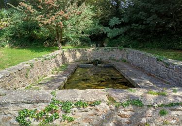
une bonne synthèse des Abers : port, sous bois, campagne et mer.