![](/images/other/stat-length.png)
![Tocht Fiets Autun - En passant par le Couchois et Nolay - Photo](https://media.geolcdn.com/t/1900/400/ext.pjpeg?maxdim=2&url=https%3A%2F%2Fservices.sitytrail.com%2FGeolivesWS%2FDownloadMedia.ashx%3FTrailID%3D103853%26Media%3D6648_1.jpg)
En passant par le Couchois et Nolay
tracegps
Gebruiker
![Lengte](/images/other/stat-length.png)
![Max. hoogte](https://static1.geolcdn.com/siteimages/upload/files/1508320355ic_sort_altitude_max_24dp.png)
![Positief hoogteverschil](https://static1.geolcdn.com/siteimages/upload/files/1508320355ic_sort_den_pos_24dp.png)
![Km-Effort](/images/other/stat-length.png)
![Min. hoogte](https://static1.geolcdn.com/siteimages/upload/files/1508320355ic_sort_altitude_min_24dp.png)
![Negatief hoogteverschil](https://static1.geolcdn.com/siteimages/upload/files/1508320355ic_sort_den_neg_24dp.png)
![Boucle](https://static1.geolcdn.com/siteimages/upload/files/16400158638029165_repeat_loop_refresh_sync_direction_icon.png)
![Fiets](https://static1.geolcdn.com/sitytour/trail-icons/200.png)
3h10
Moeilijkheid : Moeilijk
![Scan deze QR-code om de tocht te openen in de SityTrail-applicatie](https://capi.geolives.com/qq0zvz2zws4bq2lad0pu/sitytour/trails/103853/qr.png?size=200)
Gratisgps-wandelapplicatie
Over ons
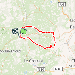
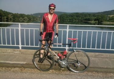
Tocht Fiets van 79 km beschikbaar op Bourgondië-Franche-Comté, Saône-et-Loire, Autun. Deze tocht wordt voorgesteld door tracegps.
Beschrijving
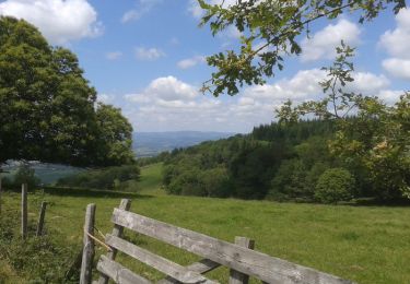
Au départ d'Autun, prendre la direction d'Auxy , quelques kilomètres de côte pour un bon échauffement. Avant Couches, après avoir viré à gauche partie très intéressante ,paysages et routes de campagne sympa... En profiter pour se ressourcer car une fois arrivé à Nolay il va falloir en remettre un coup...de pédale ...
Plaatsbepaling
Opmerkingen
Wandeltochten in de omgeving
![Tocht Stappen Autun - Autun Cascade de Brisecou page 133 - Photo](https://media.geolcdn.com/t/375/260/73ed741a-fc09-430f-83b8-8a1262a23803.jpg&format=jpg&maxdim=2)
![Stappen Stappen](https://static1.geolcdn.com/sitytour/trail-icons/101.png)
Stappen
![](/images/other/stat-length.png)
![](https://static1.geolcdn.com/siteimages/upload/files/16400158638029165_repeat_loop_refresh_sync_direction_icon.png)
![Tocht Te voet Autun - La Croix de la Libération - Photo](https://media.geolcdn.com/t/375/260/c8e08292-d93c-4948-922f-86f4acd4864a.jpeg&format=jpg&maxdim=2)
![Te voet Te voet](https://static1.geolcdn.com/sitytour/trail-icons/100.png)
Te voet
![](/images/other/stat-length.png)
![](https://static1.geolcdn.com/siteimages/upload/files/16400158638029165_repeat_loop_refresh_sync_direction_icon.png)
![Tocht Fietstoerisme Autun - 71 Bourgogne J2/8 - Photo](https://media.geolcdn.com/t/375/260/5d2c099c-6844-4211-83c2-dfd1414cd924.jpg&format=jpg&maxdim=2)
![Fietstoerisme Fietstoerisme](https://static1.geolcdn.com/sitytour/trail-icons/204.png)
Fietstoerisme
![](/images/other/stat-length.png)
![](https://static1.geolcdn.com/siteimages/upload/files/16400158638029165_repeat_loop_refresh_sync_direction_icon.png)
![Tocht Te voet Autun - V 2019-18-06-AUTUN INTRA MUROS - Photo](https://media.geolcdn.com/t/375/260/ext.jpg?maxdim=2&url=https%3A%2F%2Fstatic1.geolcdn.com%2Fsiteimages%2Fupload%2Ffiles%2F1545311037marcheuse_200dpi.jpg)
![Te voet Te voet](https://static1.geolcdn.com/sitytour/trail-icons/100.png)
Te voet
![](/images/other/stat-length.png)
![](https://static1.geolcdn.com/siteimages/upload/files/16400158638029165_repeat_loop_refresh_sync_direction_icon.png)
![Tocht Fiets Autun - Uchon par Toulongeon et Porolle - Autun - Photo](https://media.geolcdn.com/t/375/260/ext.jpg?maxdim=2&url=https%3A%2F%2Fservices.sitytrail.com%2FGeolivesWS%2FDownloadMedia.ashx%3FTrailID%3D172370%26Media%3D13713_3.jpg)
![Fiets Fiets](https://static1.geolcdn.com/sitytour/trail-icons/200.png)
Fiets
![](/images/other/stat-length.png)
![](https://static1.geolcdn.com/siteimages/upload/files/16400158638029165_repeat_loop_refresh_sync_direction_icon.png)
![Tocht Fiets Autun - Lac de Pannessiere - Photo](https://media.geolcdn.com/t/375/260/ext.jpg?maxdim=2&url=https%3A%2F%2Fservices.sitytrail.com%2FGeolivesWS%2FDownloadMedia.ashx%3FTrailID%3D105306%26Media%3D8996_3.jpg)
![Fiets Fiets](https://static1.geolcdn.com/sitytour/trail-icons/200.png)
Fiets
![](/images/other/stat-length.png)
![](https://static1.geolcdn.com/siteimages/upload/files/16400158638029165_repeat_loop_refresh_sync_direction_icon.png)
![Tocht Fiets Autun - Visinieux - Photo](https://media.geolcdn.com/t/375/260/ext.jpg?maxdim=2&url=https%3A%2F%2Fservices.sitytrail.com%2FGeolivesWS%2FDownloadMedia.ashx%3FTrailID%3D104540%26Media%3D7889_3.jpg)
![Fiets Fiets](https://static1.geolcdn.com/sitytour/trail-icons/200.png)
Fiets
![](/images/other/stat-length.png)
![](https://static1.geolcdn.com/siteimages/upload/files/16400158638029165_repeat_loop_refresh_sync_direction_icon.png)
![Tocht Mountainbike Autun - Autun - Les Feuillies - Montagne St Sébastien - La Croix de la Libération - Photo](https://media.geolcdn.com/t/375/260/ext.jpg?maxdim=2&url=https%3A%2F%2Fservices.sitytrail.com%2FGeolivesWS%2FDownloadMedia.ashx%3FTrailID%3D103938%26Media%3D6808_6.jpg)
![Mountainbike Mountainbike](https://static1.geolcdn.com/sitytour/trail-icons/202.png)
Mountainbike
![](/images/other/stat-length.png)
![](https://static1.geolcdn.com/siteimages/upload/files/16400158638029165_repeat_loop_refresh_sync_direction_icon.png)
![Tocht Wegfiets Autun - mn08 autun-Anost - Photo](https://media.geolcdn.com/t/375/260/f11796d5-17fa-4eb6-862c-e5a5dd549c79.jpg&format=jpg&maxdim=2)
![Wegfiets Wegfiets](https://static1.geolcdn.com/sitytour/trail-icons/201.png)
Wegfiets
![](/images/other/stat-length.png)
![](https://static1.geolcdn.com/siteimages/upload/files/16400158638029165_repeat_loop_refresh_sync_direction_icon.png)