![](/images/other/stat-length.png)
![Tocht Stappen Ceyreste - Les Balcons de Ceyreste - Photo](https://media.geolcdn.com/t/1900/400/ext.pjpeg?maxdim=2&url=https%3A%2F%2Fservices.sitytrail.com%2FGeolivesWS%2FDownloadMedia.ashx%3FTrailID%3D103844%26Media%3D6638_1.jpg)
Les Balcons de Ceyreste
tracegps
Gebruiker
![Lengte](/images/other/stat-length.png)
Lengte
11,3 km
![Max. hoogte](https://static1.geolcdn.com/siteimages/upload/files/1508320355ic_sort_altitude_max_24dp.png)
Max. hoogte
518 m
![Positief hoogteverschil](https://static1.geolcdn.com/siteimages/upload/files/1508320355ic_sort_den_pos_24dp.png)
Positief hoogteverschil
435 m
![Km-Effort](/images/other/stat-length.png)
Km-Effort
17,1 km
![Min. hoogte](https://static1.geolcdn.com/siteimages/upload/files/1508320355ic_sort_altitude_min_24dp.png)
Min. hoogte
122 m
![Negatief hoogteverschil](https://static1.geolcdn.com/siteimages/upload/files/1508320355ic_sort_den_neg_24dp.png)
Negatief hoogteverschil
446 m
![Boucle](https://static1.geolcdn.com/siteimages/upload/files/16400158638029165_repeat_loop_refresh_sync_direction_icon.png)
Boucle
Ja
Datum van aanmaak :
2014-12-10 00:00:00.0
Laatste wijziging :
2014-12-10 00:00:00.0
![Stappen](https://static1.geolcdn.com/sitytour/trail-icons/101.png)
3h00
Moeilijkheid : Medium
![Scan deze QR-code om de tocht te openen in de SityTrail-applicatie](https://capi.geolives.com/qq0zvz2zws4bq2lad0pu/sitytour/trails/103844/qr.png?size=200)
Gratisgps-wandelapplicatie
Over ons
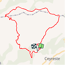
Tocht Stappen van 11,3 km beschikbaar op Provence-Alpes-Côte d'Azur, Bouches-du-Rhône, Ceyreste. Deze tocht wordt voorgesteld door tracegps.
Beschrijving
La première partie en montée continue est un peu longue. Le chemin est agréable. Difficulté moyenne. Retrouvez d’autres informations sur le site de Rando Loisirs à Carnoux en Provence.
Plaatsbepaling
Land:
France
Regio :
Provence-Alpes-Côte d'Azur
Departement/Provincie :
Bouches-du-Rhône
Gemeente :
Ceyreste
Locatie:
Unknown
Vertrek:(Dec)
Vertrek:(UTM)
713547 ; 4788811 (31T) N.
Opmerkingen
Wandeltochten in de omgeving
![Tocht Stappen Roquefort-la-Bédoule - Grand Caunet, le Montounier - Photo](https://media.geolcdn.com/t/375/260/6da96041-d8db-45b9-9840-88b8ee06ae33.jpg&format=jpg&maxdim=2)
![Stappen Stappen](https://static1.geolcdn.com/sitytour/trail-icons/101.png)
Grand Caunet, le Montounier
Stappen
Medium
(1)
Roquefort-la-Bédoule,
Provence-Alpes-Côte d'Azur,
Bouches-du-Rhône,
France
![](/images/other/stat-length.png)
16,5 km | 24 km-effort
6h 0min
![](https://static1.geolcdn.com/siteimages/upload/files/16400158638029165_repeat_loop_refresh_sync_direction_icon.png)
Ja
![Tocht Stappen Ceyreste - Autour du Montounier 2eme version - Photo](https://media.geolcdn.com/t/375/260/aea50e59-26c4-4704-b6d5-ac40178213cc.jpg&format=jpg&maxdim=2)
![Stappen Stappen](https://static1.geolcdn.com/sitytour/trail-icons/101.png)
Autour du Montounier 2eme version
Stappen
Medium
(1)
Ceyreste,
Provence-Alpes-Côte d'Azur,
Bouches-du-Rhône,
France
![](/images/other/stat-length.png)
15,7 km | 24 km-effort
6h 0min
![](https://static1.geolcdn.com/siteimages/upload/files/16400158638029165_repeat_loop_refresh_sync_direction_icon.png)
Ja
![Tocht Stappen Roquefort-la-Bédoule - SityTrail - Grand Caunet, Cabanons, Vigie , Grotte Raymond, Ruines roquefort, Chapelle St andré - Photo](https://media.geolcdn.com/t/375/260/f9c0beb6-6483-4b14-ba76-b33fa5e2208b.jpg&format=jpg&maxdim=2)
![Stappen Stappen](https://static1.geolcdn.com/sitytour/trail-icons/101.png)
SityTrail - Grand Caunet, Cabanons, Vigie , Grotte Raymond, Ruines roquefort,...
Stappen
Gemakkelijk
(1)
Roquefort-la-Bédoule,
Provence-Alpes-Côte d'Azur,
Bouches-du-Rhône,
France
![](/images/other/stat-length.png)
14,2 km | 19,9 km-effort
6h 0min
![](https://static1.geolcdn.com/siteimages/upload/files/16400158638029165_repeat_loop_refresh_sync_direction_icon.png)
Ja
![Tocht Stappen Cassis - SityTrail - cassis la couronne - Photo](https://media.geolcdn.com/t/375/260/3dbefdc1-c4a5-41cb-82fb-882826196b25.jpg&format=jpg&maxdim=2)
![Stappen Stappen](https://static1.geolcdn.com/sitytour/trail-icons/101.png)
SityTrail - cassis la couronne
Stappen
Medium
(3)
Cassis,
Provence-Alpes-Côte d'Azur,
Bouches-du-Rhône,
France
![](/images/other/stat-length.png)
16,1 km | 24 km-effort
6h 0min
![](https://static1.geolcdn.com/siteimages/upload/files/16400158638029165_repeat_loop_refresh_sync_direction_icon.png)
Ja
![Tocht Stappen Roquefort-la-Bédoule - la petite sainte baume - Photo](https://media.geolcdn.com/t/375/260/24f466c4-80fb-4267-898b-b6a75ae27664.jpg&format=jpg&maxdim=2)
![Stappen Stappen](https://static1.geolcdn.com/sitytour/trail-icons/101.png)
la petite sainte baume
Stappen
Gemakkelijk
(1)
Roquefort-la-Bédoule,
Provence-Alpes-Côte d'Azur,
Bouches-du-Rhône,
France
![](/images/other/stat-length.png)
13,9 km | 19,3 km-effort
5h 37min
![](https://static1.geolcdn.com/siteimages/upload/files/16400158638029165_repeat_loop_refresh_sync_direction_icon.png)
Ja
![Tocht Stappen La Ciotat - la ciotat - Photo](https://media.geolcdn.com/t/375/260/254a0458-8edc-4154-b242-76a735e7c994.jpg&format=jpg&maxdim=2)
![Stappen Stappen](https://static1.geolcdn.com/sitytour/trail-icons/101.png)
la ciotat
Stappen
Heel gemakkelijk
(1)
La Ciotat,
Provence-Alpes-Côte d'Azur,
Bouches-du-Rhône,
France
![](/images/other/stat-length.png)
6,2 km | 9,3 km-effort
3h 21min
![](https://static1.geolcdn.com/siteimages/upload/files/16400158638029165_repeat_loop_refresh_sync_direction_icon.png)
Ja
![Tocht Stappen Roquefort-la-Bédoule - Barres de Font Blanche - Photo](https://media.geolcdn.com/t/375/260/ext.jpg?maxdim=2&url=https%3A%2F%2Fservices.sitytrail.com%2FGeolivesWS%2FDownloadMedia.ashx%3FTrailID%3D103784%26Media%3D6554_1.jpg)
![Stappen Stappen](https://static1.geolcdn.com/sitytour/trail-icons/101.png)
Barres de Font Blanche
Stappen
Medium
(1)
Roquefort-la-Bédoule,
Provence-Alpes-Côte d'Azur,
Bouches-du-Rhône,
France
![](/images/other/stat-length.png)
10,3 km | 14,4 km-effort
2h 19min
![](https://static1.geolcdn.com/siteimages/upload/files/16400158638029165_repeat_loop_refresh_sync_direction_icon.png)
Ja
![Tocht Stappen La Ciotat - Balade La Ciotat - Photo](https://media.geolcdn.com/t/375/260/ext.jpg?maxdim=2&url=https%3A%2F%2Fstatic1.geolcdn.com%2Fsiteimages%2Fupload%2Ffiles%2F1553511878bg_sport_marche.png)
![Stappen Stappen](https://static1.geolcdn.com/sitytour/trail-icons/101.png)
Balade La Ciotat
Stappen
Moeilijk
(1)
La Ciotat,
Provence-Alpes-Côte d'Azur,
Bouches-du-Rhône,
France
![](/images/other/stat-length.png)
8,8 km | 14 km-effort
3h 7min
![](https://static1.geolcdn.com/siteimages/upload/files/16400158638029165_repeat_loop_refresh_sync_direction_icon.png)
Ja
![Tocht Stappen Roquefort-la-Bédoule - Roquefort la Bédoule - Gorges de la Petite Ste Baume - Photo](https://media.geolcdn.com/t/375/260/ext.jpg?maxdim=2&url=https%3A%2F%2Fstatic1.geolcdn.com%2Fsiteimages%2Fupload%2Ffiles%2F1553511878bg_sport_marche.png)
![Stappen Stappen](https://static1.geolcdn.com/sitytour/trail-icons/101.png)
Roquefort la Bédoule - Gorges de la Petite Ste Baume
Stappen
Medium
(2)
Roquefort-la-Bédoule,
Provence-Alpes-Côte d'Azur,
Bouches-du-Rhône,
France
![](/images/other/stat-length.png)
10,3 km | 13,8 km-effort
4h 0min
![](https://static1.geolcdn.com/siteimages/upload/files/16400158638029165_repeat_loop_refresh_sync_direction_icon.png)
Ja