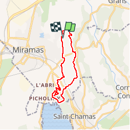
![](/images/other/stat-length.png)
![Tocht Stappen Miramas - Miramas - Fête de la randonnée 2008 - Photo](https://media.geolcdn.com/t/1900/400/ext.pjpeg?maxdim=2&url=https%3A%2F%2Fservices.sitytrail.com%2FGeolivesWS%2FDownloadMedia.ashx%3FTrailID%3D103815%26Media%3D6589_1.jpg)
Miramas - Fête de la randonnée 2008
tracegps
Gebruiker
![Lengte](/images/other/stat-length.png)
![Max. hoogte](https://static1.geolcdn.com/siteimages/upload/files/1508320355ic_sort_altitude_max_24dp.png)
![Positief hoogteverschil](https://static1.geolcdn.com/siteimages/upload/files/1508320355ic_sort_den_pos_24dp.png)
![Km-Effort](/images/other/stat-length.png)
![Min. hoogte](https://static1.geolcdn.com/siteimages/upload/files/1508320355ic_sort_altitude_min_24dp.png)
![Negatief hoogteverschil](https://static1.geolcdn.com/siteimages/upload/files/1508320355ic_sort_den_neg_24dp.png)
![Boucle](https://static1.geolcdn.com/siteimages/upload/files/16400158638029165_repeat_loop_refresh_sync_direction_icon.png)
![Stappen](https://static1.geolcdn.com/sitytour/trail-icons/101.png)
3h00
Moeilijkheid : Medium
![Scan deze QR-code om de tocht te openen in de SityTrail-applicatie](https://capi.geolives.com/qq0zvz2zws4bq2lad0pu/sitytour/trails/103815/qr.png?size=200)
Gratisgps-wandelapplicatie
Over ons
Tocht Stappen van 13,3 km beschikbaar op Provence-Alpes-Côte d'Azur, Bouches-du-Rhône, Miramas. Deze tocht wordt voorgesteld door tracegps.
Beschrijving
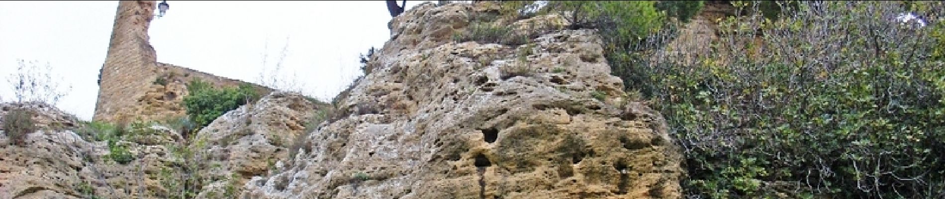
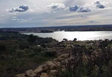
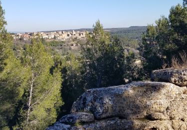
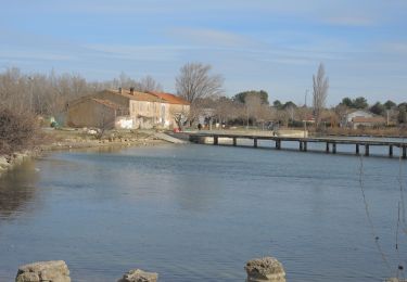
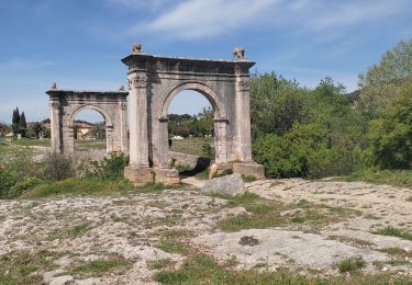
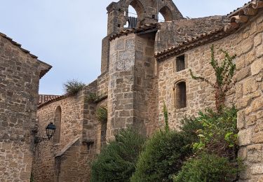
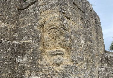
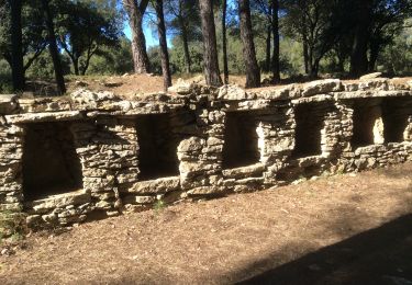
Une des randonnée réalisée lors de la fête de la randonnée organisée par le Comité Départemental de Randonnée Pédestre des Bouches du Rhône (CDRP13) le 19/10/2008. Randonnée pédestre peu difficile Niveau 3. Attention le site de la Poudrerie n'est ouvert au public que les mercredis et dimanches. Ce circuit passe dans Miramas le Vieux, beau village situé sur un promontoire et beaux points de vue tout autour notamment sur l'étang de Berre. D’autres informations sur le site de Rando Loisirs à Carnoux en Provence.
Plaatsbepaling
Opmerkingen
Wandeltochten in de omgeving
![Tocht Stappen Miramas - Miramas le vieux- tour de guet - Photo](https://media.geolcdn.com/t/375/260/bceb2c2b-a11e-4eeb-8b54-cb95c623a8a6.jpg&format=jpg&maxdim=2)
![Stappen Stappen](https://static1.geolcdn.com/sitytour/trail-icons/101.png)
Stappen
![](/images/other/stat-length.png)
![](https://static1.geolcdn.com/siteimages/upload/files/16400158638029165_repeat_loop_refresh_sync_direction_icon.png)
![Tocht Stappen Miramas - Belval-Pont de Rhaud - Photo](https://media.geolcdn.com/t/375/260/b4457b0a-c4c8-4c11-a689-47f6bf6ce055.jpg&format=jpg&maxdim=2)
![Stappen Stappen](https://static1.geolcdn.com/sitytour/trail-icons/101.png)
Stappen
![](/images/other/stat-length.png)
![](https://static1.geolcdn.com/siteimages/upload/files/16400158638029165_repeat_loop_refresh_sync_direction_icon.png)
![Stappen Stappen](https://static1.geolcdn.com/sitytour/trail-icons/101.png)
Stappen
![](/images/other/stat-length.png)
![](https://static1.geolcdn.com/siteimages/upload/files/16400158638029165_repeat_loop_refresh_sync_direction_icon.png)
![Tocht Mountainbike Istres - Challenge des entreprises Rotary Club - Photo](https://media.geolcdn.com/t/375/260/ext.jpg?maxdim=2&url=https%3A%2F%2Fstatic1.geolcdn.com%2Fsiteimages%2Fupload%2Ffiles%2F1524743154velo.jpg)
![Mountainbike Mountainbike](https://static1.geolcdn.com/sitytour/trail-icons/202.png)
Mountainbike
![](/images/other/stat-length.png)
![](https://static1.geolcdn.com/siteimages/upload/files/16400158638029165_repeat_loop_refresh_sync_direction_icon.png)
![Stappen Stappen](https://static1.geolcdn.com/sitytour/trail-icons/101.png)
Stappen
![](/images/other/stat-length.png)
![](https://static1.geolcdn.com/siteimages/upload/files/16400158638029165_repeat_loop_refresh_sync_direction_icon.png)
![Tocht Stappen Saint-Chamas - St Chamas la Touloubre - Photo](https://media.geolcdn.com/t/375/260/f9f7571a-d63b-4c1d-b704-b5de87e678de.jpg&format=jpg&maxdim=2)
![Stappen Stappen](https://static1.geolcdn.com/sitytour/trail-icons/101.png)
Stappen
![](/images/other/stat-length.png)
![](https://static1.geolcdn.com/siteimages/upload/files/16400158638029165_repeat_loop_refresh_sync_direction_icon.png)
![Tocht Stappen Miramas - Miramas le Vieux St Chamas - Photo](https://media.geolcdn.com/t/375/260/ffd9cc6f-aade-4c62-be66-d3e63bbdb2f1.jpg&format=jpg&maxdim=2)
![Stappen Stappen](https://static1.geolcdn.com/sitytour/trail-icons/101.png)
Stappen
![](/images/other/stat-length.png)
![](https://static1.geolcdn.com/siteimages/upload/files/16400158638029165_repeat_loop_refresh_sync_direction_icon.png)
![Tocht Stappen Miramas - Vieux Miramas - Photo](https://media.geolcdn.com/t/375/260/1ab1cb9f-58cd-43b8-be44-edc60b9b1d02.jpg&format=jpg&maxdim=2)
![Stappen Stappen](https://static1.geolcdn.com/sitytour/trail-icons/101.png)
Stappen
![](/images/other/stat-length.png)
![](https://static1.geolcdn.com/siteimages/upload/files/16400158638029165_repeat_loop_refresh_sync_direction_icon.png)
![Stappen Stappen](https://static1.geolcdn.com/sitytour/trail-icons/101.png)
Stappen
![](/images/other/stat-length.png)
![](https://static1.geolcdn.com/siteimages/upload/files/16400158638029165_repeat_loop_refresh_sync_direction_icon.png)