![](/images/other/stat-length.png)
![Tocht Fiets Lys-lez-Lannoy - Brevet de Lys les Lannoy - Photo](https://media.geolcdn.com/t/1900/400/ext.pjpeg?maxdim=2&url=https%3A%2F%2Fstatic1.geolcdn.com%2Fsiteimages%2Fupload%2Ffiles%2F1524743154velo.jpg)
Brevet de Lys les Lannoy
tracegps
Gebruiker
![Lengte](/images/other/stat-length.png)
Lengte
79 km
![Max. hoogte](https://static1.geolcdn.com/siteimages/upload/files/1508320355ic_sort_altitude_max_24dp.png)
Max. hoogte
109 m
![Positief hoogteverschil](https://static1.geolcdn.com/siteimages/upload/files/1508320355ic_sort_den_pos_24dp.png)
Positief hoogteverschil
658 m
![Km-Effort](/images/other/stat-length.png)
Km-Effort
87 km
![Min. hoogte](https://static1.geolcdn.com/siteimages/upload/files/1508320355ic_sort_altitude_min_24dp.png)
Min. hoogte
9 m
![Negatief hoogteverschil](https://static1.geolcdn.com/siteimages/upload/files/1508320355ic_sort_den_neg_24dp.png)
Negatief hoogteverschil
655 m
![Boucle](https://static1.geolcdn.com/siteimages/upload/files/16400158638029165_repeat_loop_refresh_sync_direction_icon.png)
Boucle
Neen
Datum van aanmaak :
2014-12-10 00:00:00.0
Laatste wijziging :
2014-12-10 00:00:00.0
![Fiets](https://static1.geolcdn.com/sitytour/trail-icons/200.png)
3h15
Moeilijkheid : Medium
![Scan deze QR-code om de tocht te openen in de SityTrail-applicatie](https://capi.geolives.com/qq0zvz2zws4bq2lad0pu/sitytour/trails/103795/qr.png?size=200)
Gratisgps-wandelapplicatie
Over ons
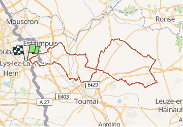
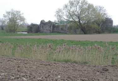
Tocht Fiets van 79 km beschikbaar op Hauts-de-France, Noorderdepartement, Lys-lez-Lannoy. Deze tocht wordt voorgesteld door tracegps.
Beschrijving
Circuit organisé à Lys les Lannoy par le cycloclub de la ville. Il se situe essentiellement sur des petites routes agréables.
Plaatsbepaling
Land:
France
Regio :
Hauts-de-France
Departement/Provincie :
Noorderdepartement
Gemeente :
Lys-lez-Lannoy
Locatie:
Unknown
Vertrek:(Dec)
Vertrek:(UTM)
516190 ; 5613780 (31U) N.
Opmerkingen
Wandeltochten in de omgeving
![Tocht Stappen Steenput - Du canal de l'Espierre à Estaimpuis - Photo](https://media.geolcdn.com/t/375/260/ext.jpg?maxdim=2&url=https%3A%2F%2Fstatic1.geolcdn.com%2Fsiteimages%2Fupload%2Ffiles%2F1553511878bg_sport_marche.png)
![Stappen Stappen](https://static1.geolcdn.com/sitytour/trail-icons/101.png)
Du canal de l'Espierre à Estaimpuis
Stappen
Gemakkelijk
(1)
Steenput,
Wallonië,
Henegouwen,
Belgium
![](/images/other/stat-length.png)
7,2 km | 7,7 km-effort
1h 41min
![](https://static1.geolcdn.com/siteimages/upload/files/16400158638029165_repeat_loop_refresh_sync_direction_icon.png)
Ja
![Tocht Stappen Leers - Leers 9,7 km - Photo](https://media.geolcdn.com/t/375/260/cb250f5b-7759-45c5-a6ff-3bcb89408c74.jpg&format=jpg&maxdim=2)
![Stappen Stappen](https://static1.geolcdn.com/sitytour/trail-icons/101.png)
Leers 9,7 km
Stappen
Gemakkelijk
Leers,
Hauts-de-France,
Noorderdepartement,
France
![](/images/other/stat-length.png)
9,7 km | 10,3 km-effort
2h 17min
![](https://static1.geolcdn.com/siteimages/upload/files/16400158638029165_repeat_loop_refresh_sync_direction_icon.png)
Ja
![Tocht Te voet Villeneuve-d'Ascq - Lac du héron - Photo](https://media.geolcdn.com/t/375/260/ext.jpg?maxdim=2&url=https%3A%2F%2Fstatic1.geolcdn.com%2Fsiteimages%2Fupload%2Ffiles%2F1545311037marcheuse_200dpi.jpg)
![Te voet Te voet](https://static1.geolcdn.com/sitytour/trail-icons/100.png)
Lac du héron
Te voet
Heel gemakkelijk
(1)
Villeneuve-d'Ascq,
Hauts-de-France,
Noorderdepartement,
France
![](/images/other/stat-length.png)
11,9 km | 13 km-effort
Onbekend
![](https://static1.geolcdn.com/siteimages/upload/files/16400158638029165_repeat_loop_refresh_sync_direction_icon.png)
Ja
![Tocht Stappen Wattrelos - Sentier de la martelotte - Photo](https://media.geolcdn.com/t/375/260/ext.jpg?maxdim=2&url=https%3A%2F%2Fstatic1.geolcdn.com%2Fsiteimages%2Fupload%2Ffiles%2F1553511878bg_sport_marche.png)
![Stappen Stappen](https://static1.geolcdn.com/sitytour/trail-icons/101.png)
Sentier de la martelotte
Stappen
Heel gemakkelijk
(1)
Wattrelos,
Hauts-de-France,
Noorderdepartement,
France
![](/images/other/stat-length.png)
4,7 km | 5,1 km-effort
57min
![](https://static1.geolcdn.com/siteimages/upload/files/16400158638029165_repeat_loop_refresh_sync_direction_icon.png)
Ja
![Tocht Stappen Sailly-lez-Lannoy - Circuit de Robigeux - Sailly lez Lannoy - Photo](https://media.geolcdn.com/t/375/260/ext.jpg?maxdim=2&url=https%3A%2F%2Fservices.sitytrail.com%2FGeolivesWS%2FDownloadMedia.ashx%3FTrailID%3D317899%26Media%3D17311_5.jpg)
![Stappen Stappen](https://static1.geolcdn.com/sitytour/trail-icons/101.png)
Circuit de Robigeux - Sailly lez Lannoy
Stappen
Medium
(3)
Sailly-lez-Lannoy,
Hauts-de-France,
Noorderdepartement,
France
![](/images/other/stat-length.png)
11,3 km | 12,3 km-effort
2h 49min
![](https://static1.geolcdn.com/siteimages/upload/files/16400158638029165_repeat_loop_refresh_sync_direction_icon.png)
Ja
![Tocht Mountainbike Villeneuve-d'Ascq - parcours des chouettes - Photo](https://media.geolcdn.com/t/375/260/ext.jpg?maxdim=2&url=https%3A%2F%2Fstatic1.geolcdn.com%2Fsiteimages%2Fupload%2Ffiles%2F1524743154velo.jpg)
![Mountainbike Mountainbike](https://static1.geolcdn.com/sitytour/trail-icons/202.png)
parcours des chouettes
Mountainbike
Gemakkelijk
(1)
Villeneuve-d'Ascq,
Hauts-de-France,
Noorderdepartement,
France
![](/images/other/stat-length.png)
38 km | 41 km-effort
2h 45min
![](https://static1.geolcdn.com/siteimages/upload/files/16400158638029165_repeat_loop_refresh_sync_direction_icon.png)
Ja
![Tocht Stappen Willems - En route pour Néchin - Willems - Photo](https://media.geolcdn.com/t/375/260/ext.jpg?maxdim=2&url=https%3A%2F%2Fservices.sitytrail.com%2FGeolivesWS%2FDownloadMedia.ashx%3FTrailID%3D173230%26Media%3D14835_4.jpg)
![Stappen Stappen](https://static1.geolcdn.com/sitytour/trail-icons/101.png)
En route pour Néchin - Willems
Stappen
Medium
(1)
Willems,
Hauts-de-France,
Noorderdepartement,
France
![](/images/other/stat-length.png)
12,5 km | 13,4 km-effort
3h 0min
![](https://static1.geolcdn.com/siteimages/upload/files/16400158638029165_repeat_loop_refresh_sync_direction_icon.png)
Ja
![Tocht Stappen Leers - Circuit des 2 Leers - Photo](https://media.geolcdn.com/t/375/260/ext.jpg?maxdim=2&url=https%3A%2F%2Fservices.sitytrail.com%2FGeolivesWS%2FDownloadMedia.ashx%3FTrailID%3D109002%26Media%3D2943_6.jpg)
![Stappen Stappen](https://static1.geolcdn.com/sitytour/trail-icons/101.png)
Circuit des 2 Leers
Stappen
Medium
(1)
Leers,
Hauts-de-France,
Noorderdepartement,
France
![](/images/other/stat-length.png)
10,7 km | 11,3 km-effort
2h 45min
![](https://static1.geolcdn.com/siteimages/upload/files/16400158638029165_repeat_loop_refresh_sync_direction_icon.png)
Ja
![Tocht Stappen Robaais - Roubaix 15 km - Photo](https://media.geolcdn.com/t/375/260/ext.jpg?maxdim=2&url=https%3A%2F%2Fstatic1.geolcdn.com%2Fsiteimages%2Fupload%2Ffiles%2F1553511878bg_sport_marche.png)
![Stappen Stappen](https://static1.geolcdn.com/sitytour/trail-icons/101.png)
Roubaix 15 km
Stappen
Heel gemakkelijk
Robaais,
Hauts-de-France,
Noorderdepartement,
France
![](/images/other/stat-length.png)
16 km | 17,5 km-effort
3h 51min
![](https://static1.geolcdn.com/siteimages/upload/files/16400158638029165_repeat_loop_refresh_sync_direction_icon.png)
Ja