![](/images/other/stat-length.png)
![Tocht Fiets Malaucène - Le Ventoux Cyclo par la face Nord - Photo](https://media.geolcdn.com/t/1900/400/ext.pjpeg?maxdim=2&url=https%3A%2F%2Fservices.sitytrail.com%2FGeolivesWS%2FDownloadMedia.ashx%3FTrailID%3D103764%26Media%3D6513_1.jpg)
Le Ventoux Cyclo par la face Nord
tracegps
Gebruiker
![Lengte](/images/other/stat-length.png)
Lengte
54 km
![Max. hoogte](https://static1.geolcdn.com/siteimages/upload/files/1508320355ic_sort_altitude_max_24dp.png)
Max. hoogte
1902 m
![Positief hoogteverschil](https://static1.geolcdn.com/siteimages/upload/files/1508320355ic_sort_den_pos_24dp.png)
Positief hoogteverschil
1813 m
![Km-Effort](/images/other/stat-length.png)
Km-Effort
79 km
![Min. hoogte](https://static1.geolcdn.com/siteimages/upload/files/1508320355ic_sort_altitude_min_24dp.png)
Min. hoogte
310 m
![Negatief hoogteverschil](https://static1.geolcdn.com/siteimages/upload/files/1508320355ic_sort_den_neg_24dp.png)
Negatief hoogteverschil
1816 m
![Boucle](https://static1.geolcdn.com/siteimages/upload/files/16400158638029165_repeat_loop_refresh_sync_direction_icon.png)
Boucle
Ja
Datum van aanmaak :
2014-12-10 00:00:00.0
Laatste wijziging :
2014-12-10 00:00:00.0
![Fiets](https://static1.geolcdn.com/sitytour/trail-icons/200.png)
3h19
Moeilijkheid : Zeer moeilijk
![Scan deze QR-code om de tocht te openen in de SityTrail-applicatie](https://capi.geolives.com/qq0zvz2zws4bq2lad0pu/sitytour/trails/103764/qr.png?size=200)
Gratisgps-wandelapplicatie
Over ons
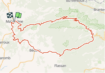
Tocht Fiets van 54 km beschikbaar op Provence-Alpes-Côte d'Azur, Vaucluse, Malaucène. Deze tocht wordt voorgesteld door tracegps.
Beschrijving
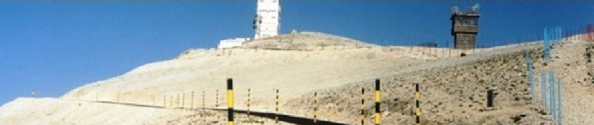
Partir à froid de Malaucène, on n'a pas le temps de stresser, on est de suite dans le coup....de pédale. La prochaine fois à faire par la face sud ou en VTT.
Plaatsbepaling
Land:
France
Regio :
Provence-Alpes-Côte d'Azur
Departement/Provincie :
Vaucluse
Gemeente :
Malaucène
Locatie:
Unknown
Vertrek:(Dec)
Vertrek:(UTM)
670477 ; 4893195 (31T) N.
Opmerkingen
Wandeltochten in de omgeving
![Tocht Stappen Entrechaux - Entrechaux en Vaucluse - Photo](https://media.geolcdn.com/t/375/260/ext.jpg?maxdim=2&url=https%3A%2F%2Fservices.sitytrail.com%2FGeolivesWS%2FDownloadMedia.ashx%3FTrailID%3D107158%26Media%3D12001_3.jpg)
![Stappen Stappen](https://static1.geolcdn.com/sitytour/trail-icons/101.png)
Entrechaux en Vaucluse
Stappen
Medium
(1)
Entrechaux,
Provence-Alpes-Côte d'Azur,
Vaucluse,
France
![](/images/other/stat-length.png)
9,5 km | 13,7 km-effort
2h 40min
![](https://static1.geolcdn.com/siteimages/upload/files/16400158638029165_repeat_loop_refresh_sync_direction_icon.png)
Ja
![Tocht Stappen Saint-Hippolyte-le-Graveyron - Le graveron petit circuit - Photo](https://media.geolcdn.com/t/375/260/e8a95e9c-8711-4425-b0b6-166adebefe20.jpg&format=jpg&maxdim=2)
![Stappen Stappen](https://static1.geolcdn.com/sitytour/trail-icons/101.png)
Le graveron petit circuit
Stappen
Gemakkelijk
(1)
Saint-Hippolyte-le-Graveyron,
Provence-Alpes-Côte d'Azur,
Vaucluse,
France
![](/images/other/stat-length.png)
5,7 km | 8,8 km-effort
2h 5min
![](https://static1.geolcdn.com/siteimages/upload/files/16400158638029165_repeat_loop_refresh_sync_direction_icon.png)
Ja
![Tocht Stappen Le Barroux - Les Crêtes du Graveyron par l'écluse de la Falque - Photo](https://media.geolcdn.com/t/375/260/d8a64516-5e96-4aec-9024-3e89e87cb4a5.jpg&format=jpg&maxdim=2)
![Stappen Stappen](https://static1.geolcdn.com/sitytour/trail-icons/101.png)
Les Crêtes du Graveyron par l'écluse de la Falque
Stappen
Moeilijk
Le Barroux,
Provence-Alpes-Côte d'Azur,
Vaucluse,
France
![](/images/other/stat-length.png)
9 km | 13,4 km-effort
2h 57min
![](https://static1.geolcdn.com/siteimages/upload/files/16400158638029165_repeat_loop_refresh_sync_direction_icon.png)
Ja
![Tocht Stappen Caromb - Les 3 Termes 449 le Groseau - Photo](https://media.geolcdn.com/t/375/260/10d32099-293b-4d37-bbde-b3ecd67a6725.jpg&format=jpg&maxdim=2)
![Stappen Stappen](https://static1.geolcdn.com/sitytour/trail-icons/101.png)
Les 3 Termes 449 le Groseau
Stappen
Medium
Caromb,
Provence-Alpes-Côte d'Azur,
Vaucluse,
France
![](/images/other/stat-length.png)
11,1 km | 16,9 km-effort
2h 56min
![](https://static1.geolcdn.com/siteimages/upload/files/16400158638029165_repeat_loop_refresh_sync_direction_icon.png)
Ja
![Tocht Stappen La Roque-Alric - Les 4 sommets de la Roque Alric - Photo](https://media.geolcdn.com/t/375/260/e93bea38-2e31-43c6-94e2-77f41c5e7792.jpg&format=jpg&maxdim=2)
![Stappen Stappen](https://static1.geolcdn.com/sitytour/trail-icons/101.png)
Les 4 sommets de la Roque Alric
Stappen
Medium
La Roque-Alric,
Provence-Alpes-Côte d'Azur,
Vaucluse,
France
![](/images/other/stat-length.png)
10,9 km | 18 km-effort
3h 32min
![](https://static1.geolcdn.com/siteimages/upload/files/16400158638029165_repeat_loop_refresh_sync_direction_icon.png)
Ja
![Tocht Stappen La Roque-Alric - Rochers des Évêques - Photo](https://media.geolcdn.com/t/375/260/07ede647-be75-4726-a51b-6e74ff5b2210.jpg&format=jpg&maxdim=2)
![Stappen Stappen](https://static1.geolcdn.com/sitytour/trail-icons/101.png)
Rochers des Évêques
Stappen
Medium
La Roque-Alric,
Provence-Alpes-Côte d'Azur,
Vaucluse,
France
![](/images/other/stat-length.png)
6,7 km | 11 km-effort
2h 26min
![](https://static1.geolcdn.com/siteimages/upload/files/16400158638029165_repeat_loop_refresh_sync_direction_icon.png)
Ja
![Tocht Stappen Le Barroux - Lac du Barroux - Photo](https://media.geolcdn.com/t/375/260/ext.jpg?maxdim=2&url=https%3A%2F%2Fservices.sitytrail.com%2FGeolivesWS%2FDownloadMedia.ashx%3FTrailID%3D254117%26Media%3Dfix__20140304143604.jpg)
![Stappen Stappen](https://static1.geolcdn.com/sitytour/trail-icons/101.png)
Lac du Barroux
Stappen
Heel gemakkelijk
(2)
Le Barroux,
Provence-Alpes-Côte d'Azur,
Vaucluse,
France
![](/images/other/stat-length.png)
5,8 km | 8 km-effort
1h 42min
![](https://static1.geolcdn.com/siteimages/upload/files/16400158638029165_repeat_loop_refresh_sync_direction_icon.png)
Ja
![Tocht Lopen Le Barroux - Sortie Barroux - Photo](https://media.geolcdn.com/t/375/260/ext.jpg?maxdim=2&url=https%3A%2F%2Fstatic1.geolcdn.com%2Fsiteimages%2Fupload%2Ffiles%2F1524743154running.jpg)
![Lopen Lopen](https://static1.geolcdn.com/sitytour/trail-icons/103.png)
Sortie Barroux
Lopen
Heel gemakkelijk
(1)
Le Barroux,
Provence-Alpes-Côte d'Azur,
Vaucluse,
France
![](/images/other/stat-length.png)
12,9 km | 20 km-effort
1h 47min
![](https://static1.geolcdn.com/siteimages/upload/files/16400158638029165_repeat_loop_refresh_sync_direction_icon.png)
Ja
![Tocht Stappen Malaucène - Campagne de Malaucène - Photo](https://media.geolcdn.com/t/375/260/ext.jpg?maxdim=2&url=https%3A%2F%2Fstatic1.geolcdn.com%2Fsiteimages%2Fupload%2Ffiles%2F1553511878bg_sport_marche.png)
![Stappen Stappen](https://static1.geolcdn.com/sitytour/trail-icons/101.png)
Campagne de Malaucène
Stappen
Gemakkelijk
(2)
Malaucène,
Provence-Alpes-Côte d'Azur,
Vaucluse,
France
![](/images/other/stat-length.png)
6,6 km | 8,1 km-effort
1h 30min
![](https://static1.geolcdn.com/siteimages/upload/files/16400158638029165_repeat_loop_refresh_sync_direction_icon.png)
Ja