![](/images/other/stat-length.png)
![Tocht Lopen Katzenthal - Montée du Galtz - Katzenthal - Photo](https://media.geolcdn.com/t/1900/400/ext.pjpeg?maxdim=2&url=https%3A%2F%2Fservices.sitytrail.com%2FGeolivesWS%2FDownloadMedia.ashx%3FTrailID%3D103720%26Media%3D6317_1.jpg)
Montée du Galtz - Katzenthal
tracegps
Gebruiker
![Lengte](/images/other/stat-length.png)
Lengte
8 km
![Max. hoogte](https://static1.geolcdn.com/siteimages/upload/files/1508320355ic_sort_altitude_max_24dp.png)
Max. hoogte
719 m
![Positief hoogteverschil](https://static1.geolcdn.com/siteimages/upload/files/1508320355ic_sort_den_pos_24dp.png)
Positief hoogteverschil
456 m
![Km-Effort](/images/other/stat-length.png)
Km-Effort
14,1 km
![Min. hoogte](https://static1.geolcdn.com/siteimages/upload/files/1508320355ic_sort_altitude_min_24dp.png)
Min. hoogte
272 m
![Negatief hoogteverschil](https://static1.geolcdn.com/siteimages/upload/files/1508320355ic_sort_den_neg_24dp.png)
Negatief hoogteverschil
456 m
![Boucle](https://static1.geolcdn.com/siteimages/upload/files/16400158638029165_repeat_loop_refresh_sync_direction_icon.png)
Boucle
Ja
Datum van aanmaak :
2014-12-10 00:00:00.0
Laatste wijziging :
2014-12-10 00:00:00.0
![Lopen](https://static1.geolcdn.com/sitytour/trail-icons/103.png)
45m
Moeilijkheid : Medium
![Scan deze QR-code om de tocht te openen in de SityTrail-applicatie](https://capi.geolives.com/qq0zvz2zws4bq2lad0pu/sitytour/trails/103720/qr.png?size=200)
Gratisgps-wandelapplicatie
Over ons
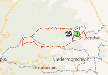
Tocht Lopen van 8 km beschikbaar op Grand Est, Haut-Rhin, Katzenthal. Deze tocht wordt voorgesteld door tracegps.
Beschrijving
Très beau parcours, on se retrouve au pieds de la statue de jésus au sommet du Galtz. Une fois monté au dessus de la tour, quelle récompense !
Plaatsbepaling
Land:
France
Regio :
Grand Est
Departement/Provincie :
Haut-Rhin
Gemeente :
Katzenthal
Locatie:
Unknown
Vertrek:(Dec)
Vertrek:(UTM)
371602 ; 5329624 (32U) N.
Opmerkingen
Wandeltochten in de omgeving
![Tocht Stappen Ammerschwihr - D'Ammerschwihr aux Trois Epis - Photo](https://media.geolcdn.com/t/375/260/ext.jpg?maxdim=2&url=https%3A%2F%2Fservices.sitytrail.com%2FGeolivesWS%2FDownloadMedia.ashx%3FTrailID%3D404804%26Media%3Dfix__20150406154748.jpg)
![Stappen Stappen](https://static1.geolcdn.com/sitytour/trail-icons/101.png)
D'Ammerschwihr aux Trois Epis
Stappen
Moeilijk
(1)
Ammerschwihr,
Grand Est,
Haut-Rhin,
France
![](/images/other/stat-length.png)
17,1 km | 25 km-effort
5h 35min
![](https://static1.geolcdn.com/siteimages/upload/files/16400158638029165_repeat_loop_refresh_sync_direction_icon.png)
Ja
![Tocht Stappen Ammerschwihr - Trois Épis le rocher du corbeau - Photo](https://media.geolcdn.com/t/375/260/dbdb5766-f574-4a80-9cd8-371c84f0061c.jpg&format=jpg&maxdim=2)
![Stappen Stappen](https://static1.geolcdn.com/sitytour/trail-icons/101.png)
Trois Épis le rocher du corbeau
Stappen
Gemakkelijk
(2)
Ammerschwihr,
Grand Est,
Haut-Rhin,
France
![](/images/other/stat-length.png)
4,4 km | 5,7 km-effort
59min
![](https://static1.geolcdn.com/siteimages/upload/files/16400158638029165_repeat_loop_refresh_sync_direction_icon.png)
Ja
![Tocht Stappen Kaysersberg-Vignoble - Du ⛺️ aux 4 villages - Photo](https://media.geolcdn.com/t/375/260/47566d1f-1190-42ce-9084-8a92c1b5deab.jpg&format=jpg&maxdim=2)
![Stappen Stappen](https://static1.geolcdn.com/sitytour/trail-icons/101.png)
Du ⛺️ aux 4 villages
Stappen
Medium
Kaysersberg-Vignoble,
Grand Est,
Haut-Rhin,
France
![](/images/other/stat-length.png)
12,9 km | 15,1 km-effort
3h 30min
![](https://static1.geolcdn.com/siteimages/upload/files/16400158638029165_repeat_loop_refresh_sync_direction_icon.png)
Ja
![Tocht Stappen Wintzenheim - Boucle de la fontaine de la dame - Photo](https://media.geolcdn.com/t/375/260/ee79f3ee-48dc-4e78-8e39-2ea9fd8c2e7b.jpg&format=jpg&maxdim=2)
![Stappen Stappen](https://static1.geolcdn.com/sitytour/trail-icons/101.png)
Boucle de la fontaine de la dame
Stappen
Medium
Wintzenheim,
Grand Est,
Haut-Rhin,
France
![](/images/other/stat-length.png)
7,9 km | 12,6 km-effort
2h 0min
![](https://static1.geolcdn.com/siteimages/upload/files/16400158638029165_repeat_loop_refresh_sync_direction_icon.png)
Ja
![Tocht Stappen Kaysersberg-Vignoble - 2021-05-30 Marche Kaysersberg Ursprung St Alexis - Photo](https://media.geolcdn.com/t/375/260/4ae16611-5255-49df-be17-2a5aa0e78321.jpg&format=jpg&maxdim=2)
![Stappen Stappen](https://static1.geolcdn.com/sitytour/trail-icons/101.png)
2021-05-30 Marche Kaysersberg Ursprung St Alexis
Stappen
Zeer moeilijk
Kaysersberg-Vignoble,
Grand Est,
Haut-Rhin,
France
![](/images/other/stat-length.png)
17,1 km | 26 km-effort
4h 46min
![](https://static1.geolcdn.com/siteimages/upload/files/16400158638029165_repeat_loop_refresh_sync_direction_icon.png)
Ja
![Tocht Paardrijden Kaysersberg-Vignoble - 2019-10-26 CDTE67 Tournage Video Promotion TE - Photo](https://media.geolcdn.com/t/375/260/d78bcf89-6739-4bcc-854f-0c743f5412b8.jpg&format=jpg&maxdim=2)
![Paardrijden Paardrijden](https://static1.geolcdn.com/sitytour/trail-icons/301.png)
2019-10-26 CDTE67 Tournage Video Promotion TE
Paardrijden
Gemakkelijk
Kaysersberg-Vignoble,
Grand Est,
Haut-Rhin,
France
![](/images/other/stat-length.png)
24 km | 29 km-effort
24min
![](https://static1.geolcdn.com/siteimages/upload/files/16400158638029165_repeat_loop_refresh_sync_direction_icon.png)
Neen
![Tocht Paardrijden Kaysersberg-Vignoble - 000004 - Photo](https://media.geolcdn.com/t/375/260/fc80041c-b401-476e-a019-02f21cb51a95.jpg&format=jpg&maxdim=2)
![Paardrijden Paardrijden](https://static1.geolcdn.com/sitytour/trail-icons/301.png)
000004
Paardrijden
Zeer moeilijk
Kaysersberg-Vignoble,
Grand Est,
Haut-Rhin,
France
![](/images/other/stat-length.png)
32 km | 45 km-effort
5h 55min
![](https://static1.geolcdn.com/siteimages/upload/files/16400158638029165_repeat_loop_refresh_sync_direction_icon.png)
Ja
![Tocht Stappen Kaysersberg-Vignoble - Le tour de Kysersberg - Photo](https://media.geolcdn.com/t/375/260/ext.jpg?maxdim=2&url=https%3A%2F%2Fservices.sitytrail.com%2FGeolivesWS%2FDownloadMedia.ashx%3FTrailID%3D482177%26Media%3D9aff239b-2fb3-4dd0-a536-a4dc7a8f2dee.jpg)
![Stappen Stappen](https://static1.geolcdn.com/sitytour/trail-icons/101.png)
Le tour de Kysersberg
Stappen
Medium
(1)
Kaysersberg-Vignoble,
Grand Est,
Haut-Rhin,
France
![](/images/other/stat-length.png)
7,9 km | 11,7 km-effort
2h 34min
![](https://static1.geolcdn.com/siteimages/upload/files/16400158638029165_repeat_loop_refresh_sync_direction_icon.png)
Ja
![Tocht Mountainbike Wintzenheim - Wintzenheim - Le Stauffen - Col de Marbach - Soultzbach - Photo](https://media.geolcdn.com/t/375/260/ext.jpg?maxdim=2&url=https%3A%2F%2Fstatic1.geolcdn.com%2Fsiteimages%2Fupload%2Ffiles%2F1524743154velo.jpg)
![Mountainbike Mountainbike](https://static1.geolcdn.com/sitytour/trail-icons/202.png)
Wintzenheim - Le Stauffen - Col de Marbach - Soultzbach
Mountainbike
Medium
(1)
Wintzenheim,
Grand Est,
Haut-Rhin,
France
![](/images/other/stat-length.png)
23 km | 31 km-effort
2h 4min
![](https://static1.geolcdn.com/siteimages/upload/files/16400158638029165_repeat_loop_refresh_sync_direction_icon.png)
Ja