![](/images/other/stat-length.png)
![Tocht Stappen Laveissière - le Peyre Arse - Le Lioran - Photo](https://media.geolcdn.com/t/1900/400/ext.pjpeg?maxdim=2&url=https%3A%2F%2Fservices.sitytrail.com%2FGeolivesWS%2FDownloadMedia.ashx%3FTrailID%3D103642%26Media%3D6060_2.jpg)
le Peyre Arse - Le Lioran
tracegps
Gebruiker
![Lengte](/images/other/stat-length.png)
![Max. hoogte](https://static1.geolcdn.com/siteimages/upload/files/1508320355ic_sort_altitude_max_24dp.png)
![Positief hoogteverschil](https://static1.geolcdn.com/siteimages/upload/files/1508320355ic_sort_den_pos_24dp.png)
![Km-Effort](/images/other/stat-length.png)
![Min. hoogte](https://static1.geolcdn.com/siteimages/upload/files/1508320355ic_sort_altitude_min_24dp.png)
![Negatief hoogteverschil](https://static1.geolcdn.com/siteimages/upload/files/1508320355ic_sort_den_neg_24dp.png)
![Boucle](https://static1.geolcdn.com/siteimages/upload/files/16400158638029165_repeat_loop_refresh_sync_direction_icon.png)
![Stappen](https://static1.geolcdn.com/sitytour/trail-icons/101.png)
4h00
Moeilijkheid : Moeilijk
![Scan deze QR-code om de tocht te openen in de SityTrail-applicatie](https://capi.geolives.com/qq0zvz2zws4bq2lad0pu/sitytour/trails/103642/qr.png?size=200)
Gratisgps-wandelapplicatie
Over ons
Tocht Stappen van 11,2 km beschikbaar op Auvergne-Rhône-Alpes, Cantal, Laveissière. Deze tocht wordt voorgesteld door tracegps.
Beschrijving
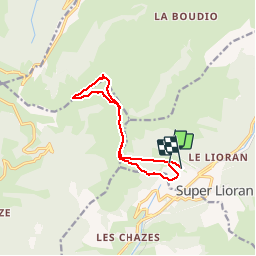
l’itinéraire, non conventionnel, n’est pas compliqué ! Nul besoin de GPS, sauf bien sûr si le brouillard faisait son apparition… Le but : monter au Peyre Arse (alt : 1808m) dans l’après-midi et sans trop de fatigue. On prend d’abord le télésiège de Rombière histoire de découvrir l’engin et de contempler la montagne autrement. On accède à l’appareil par le fond de l’Allagnon où se trouve un grand parking. On arrive au col de Rombière (alt 1528m.) après une montée de 350m. puis en suivant la crête on se dirige au col de Cabre où les vues sont superbes. Mais le plus beau c’est au sommet du Peyre Arse …retour par l’arête NE-SO, le col de Cabre, et le bois de Combe Nègre
Plaatsbepaling
Opmerkingen
Wandeltochten in de omgeving
![Tocht Stappen Albepierre-Bredons - Cantal - Col de Prat de Bouc Le Plomb du Cantal - 8.2km 450m 2h45 - 2019 07 06 - Photo](https://media.geolcdn.com/t/375/260/1b4e5d5e-f4da-4328-b35b-79db214ae669.jpg&format=jpg&maxdim=2)
![Stappen Stappen](https://static1.geolcdn.com/sitytour/trail-icons/101.png)
Stappen
![](/images/other/stat-length.png)
![](https://static1.geolcdn.com/siteimages/upload/files/16400158638029165_repeat_loop_refresh_sync_direction_icon.png)
![Tocht Stappen Lavigerie - Le Puy de Peyre Arse depuis la Gravière - Photo](https://media.geolcdn.com/t/375/260/ext.jpg?maxdim=2&url=https%3A%2F%2Fservices.sitytrail.com%2FGeolivesWS%2FDownloadMedia.ashx%3FTrailID%3D172317%26Media%3D13640_5.jpg)
![Stappen Stappen](https://static1.geolcdn.com/sitytour/trail-icons/101.png)
Stappen
![](/images/other/stat-length.png)
![](https://static1.geolcdn.com/siteimages/upload/files/16400158638029165_repeat_loop_refresh_sync_direction_icon.png)
![Tocht Stappen Laveissière - Le Puy Griou de Super Lioran - Photo](https://media.geolcdn.com/t/375/260/ext.jpg?maxdim=2&url=https%3A%2F%2Fservices.sitytrail.com%2FGeolivesWS%2FDownloadMedia.ashx%3FTrailID%3D105565%26Media%3D9330_5.jpg)
![Stappen Stappen](https://static1.geolcdn.com/sitytour/trail-icons/101.png)
Stappen
![](/images/other/stat-length.png)
![](https://static1.geolcdn.com/siteimages/upload/files/16400158638029165_repeat_loop_refresh_sync_direction_icon.png)
![Tocht Stappen Laveissière - Le plomb du Cantal - Le Lioran - Photo](https://media.geolcdn.com/t/375/260/ext.jpg?maxdim=2&url=https%3A%2F%2Fservices.sitytrail.com%2FGeolivesWS%2FDownloadMedia.ashx%3FTrailID%3D105562%26Media%3D9325_5.jpg)
![Stappen Stappen](https://static1.geolcdn.com/sitytour/trail-icons/101.png)
Stappen
![](/images/other/stat-length.png)
![](https://static1.geolcdn.com/siteimages/upload/files/16400158638029165_repeat_loop_refresh_sync_direction_icon.png)
![Tocht Stappen Laveissière - Les crêtes du Cantal - Le Lioran - Photo](https://media.geolcdn.com/t/375/260/ext.jpg?maxdim=2&url=https%3A%2F%2Fservices.sitytrail.com%2FGeolivesWS%2FDownloadMedia.ashx%3FTrailID%3D106122%26Media%3D10357_2.jpg)
![Stappen Stappen](https://static1.geolcdn.com/sitytour/trail-icons/101.png)
Stappen
![](/images/other/stat-length.png)
![](https://static1.geolcdn.com/siteimages/upload/files/16400158638029165_repeat_loop_refresh_sync_direction_icon.png)
![Tocht Stappen Laveissière - Lioran 2023-08-18 Col de Rombière Col du Pertus A/R - Photo](https://media.geolcdn.com/t/375/260/ext.jpg?maxdim=2&url=https%3A%2F%2Fstatic1.geolcdn.com%2Fsiteimages%2Fupload%2Ffiles%2F1553511878bg_sport_marche.png)
![Stappen Stappen](https://static1.geolcdn.com/sitytour/trail-icons/101.png)
Stappen
![](/images/other/stat-length.png)
![](https://static1.geolcdn.com/siteimages/upload/files/16400158638029165_repeat_loop_refresh_sync_direction_icon.png)
![Tocht Stappen Laveissière - Lioran 2023-08-11 Col du Pertus - Photo](https://media.geolcdn.com/t/375/260/ext.jpg?maxdim=2&url=https%3A%2F%2Fstatic1.geolcdn.com%2Fsiteimages%2Fupload%2Ffiles%2F1553511878bg_sport_marche.png)
![Stappen Stappen](https://static1.geolcdn.com/sitytour/trail-icons/101.png)
Stappen
![](/images/other/stat-length.png)
![](https://static1.geolcdn.com/siteimages/upload/files/16400158638029165_repeat_loop_refresh_sync_direction_icon.png)
![Tocht Stappen Laveissière - Lioran 2023-08-09 Puy de Seycheuse - Photo](https://media.geolcdn.com/t/375/260/ext.jpg?maxdim=2&url=https%3A%2F%2Fstatic1.geolcdn.com%2Fsiteimages%2Fupload%2Ffiles%2F1553511878bg_sport_marche.png)
![Stappen Stappen](https://static1.geolcdn.com/sitytour/trail-icons/101.png)
Stappen
![](/images/other/stat-length.png)
![](https://static1.geolcdn.com/siteimages/upload/files/16400158638029165_repeat_loop_refresh_sync_direction_icon.png)
![Tocht Trail Laveissière - Puy de Peyre Arse/ Puy Bataillouse / Téton de Vénus et Rocher du bec de l'aigle - Photo](https://media.geolcdn.com/t/375/260/2efbec1e-0f56-4871-abca-4b6cd09b30d9.jpg&format=jpg&maxdim=2)
![Trail Trail](https://static1.geolcdn.com/sitytour/trail-icons/104.png)
Trail
![](/images/other/stat-length.png)
![](https://static1.geolcdn.com/siteimages/upload/files/16400158638029165_repeat_loop_refresh_sync_direction_icon.png)
belle rando