Tocht Stappen Aumont-en-Halatte - Sur le Mont Alta - Photo
 tracegps
tracegps

Gebruiker

© OpenStreetMap contributors
Lengte
Lengte
6,1 km
Max. hoogte
Max. hoogte
152 m
Positief hoogteverschil
77 m
Km-Effort
Km-Effort  
7,1 km
Min. hoogte
Min. hoogte
105 m
Negatief hoogteverschil
78 m
Boucle
Boucle
Ja
Datum van aanmaak :
2014-12-10 00:00:00.0
Laatste wijziging :
2014-12-10 00:00:00.0

(0 Bericht)

Stappen
Stappen
1h30
Moeilijkheid : Medium

Scan deze QR-code om de tocht te openen in de SityTrail-applicatie

Gratisgps-wandelapplicatie

Logo SityTrail SityTrail

IGN / Geografische instituten

SityTrail uit de App Store downloaden SityTrail uit Google Play downloaden

Logo SityTrail SityTrail World

De wereld gaat voor u open

SityTrail uit de App Store downloaden SityTrail uit Google Play downloaden SityTrail op Huawei AppGallery downloaden

Over ons

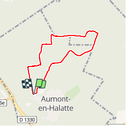
Tocht Stappen van 6,1 km beschikbaar op Hauts-de-France, Oise, Aumont-en-Halatte. Deze tocht wordt voorgesteld door tracegps.

Beschrijving

Circuit proposé par le Parc Naturel Régional Oise-Pays de France. Fiche disponible ICI Trace GPS enregistrée le 14/07/2009 sur Evadeo Primo

Hoogteprofiel

Plaatsbepaling

Land:
France
Regio :
Hauts-de-France
Departement/Provincie :
Oise
Gemeente :
Aumont-en-Halatte
Locatie:
Unknown
Vertrek:(Dec)
Vertrek:(UTM)
466986 ; 5453267 (31U) N.

Wandeltochten in de omgeving

Tocht Te voet Senlis - SENLIS CITE ROYALE(FFK) - Photo
Te voet
GR77LP

Te voet

Heel gemakkelijk
(1)
Senlis, Hauts-de-France, Oise, France
4,6 km | 5,2 km-effort
2h 0min
Ja
Tocht Stappen Fleurines - Fleurines Grand parcours - Photo
Stappen
CC.RIDER

Stappen

Gemakkelijk
(1)
Fleurines, Hauts-de-France, Oise, France
20 km | 24 km-effort
5h 8min
Ja
Tocht Stappen Apremont - apremont 60300 - Photo
Stappen
dartoisclaude

Stappen

Moeilijk
(1)
Apremont, Hauts-de-France, Oise, France
20 km | 23 km-effort
4h 49min
Ja
Tocht Stappen Chamant - Chamant Supermini-rando - Photo
Stappen
CC.RIDER

Stappen

Gemakkelijk
(8)
Chamant, Hauts-de-France, Oise, France
8 km | 9,3 km-effort
2h 7min
Ja
Tocht Te voet Senlis - De Orrouy à Coye - Photo
Te voet
GUIDE+

Te voet

Gemakkelijk
Senlis, Hauts-de-France, Oise, France
10,1 km | 11,2 km-effort
2h 33min
Neen
Tocht Te voet Aumont-en-Halatte - Chemin Royal - Photo
Te voet
GUIDE+

Te voet

Gemakkelijk
Aumont-en-Halatte, Hauts-de-France, Oise, France
3,5 km | 4 km-effort
54min
Neen
Tocht Stappen Avilly-Saint-Léonard - randonnée en forêt de chantilly - Photo
Stappen
jumetz philippe

Stappen

Heel gemakkelijk
Avilly-Saint-Léonard, Hauts-de-France, Oise, France
12,1 km | 13,2 km-effort
2h 54min
Ja
Tocht Stappen Fleurines - Fleurines_StChristophe_12,7 km_Trace GPS - Photo
Stappen
Pousscailleux

Stappen

Medium
(1)
Fleurines, Hauts-de-France, Oise, France
12,7 km | 15,6 km-effort
2h 42min
Ja
Tocht Mountainbike Chantilly - Dans la forêt de Chantilly - Photo
Mountainbike
tracegps

Mountainbike

Medium
Chantilly, Hauts-de-France, Oise, France
19,7 km | 22 km-effort
1h 30min
Ja


Sluiten
Mijn abonnementen