![](/images/other/stat-length.png)
![Tocht Mountainbike Moulineaux - Rando raid la Troglodyte - Photo](https://media.geolcdn.com/t/1900/400/ext.pjpeg?maxdim=2&url=https%3A%2F%2Fservices.sitytrail.com%2FGeolivesWS%2FDownloadMedia.ashx%3FTrailID%3D103544%26Media%3D5763_5.jpg)
Rando raid la Troglodyte
tracegps
Gebruiker
![Lengte](/images/other/stat-length.png)
![Max. hoogte](https://static1.geolcdn.com/siteimages/upload/files/1508320355ic_sort_altitude_max_24dp.png)
![Positief hoogteverschil](https://static1.geolcdn.com/siteimages/upload/files/1508320355ic_sort_den_pos_24dp.png)
![Km-Effort](/images/other/stat-length.png)
![Min. hoogte](https://static1.geolcdn.com/siteimages/upload/files/1508320355ic_sort_altitude_min_24dp.png)
![Negatief hoogteverschil](https://static1.geolcdn.com/siteimages/upload/files/1508320355ic_sort_den_neg_24dp.png)
![Boucle](https://static1.geolcdn.com/siteimages/upload/files/16400158638029165_repeat_loop_refresh_sync_direction_icon.png)
![Mountainbike](https://static1.geolcdn.com/sitytour/trail-icons/202.png)
3h00
Moeilijkheid : Zeer moeilijk
![Scan deze QR-code om de tocht te openen in de SityTrail-applicatie](https://capi.geolives.com/qq0zvz2zws4bq2lad0pu/sitytour/trails/103544/qr.png?size=200)
Gratisgps-wandelapplicatie
Over ons
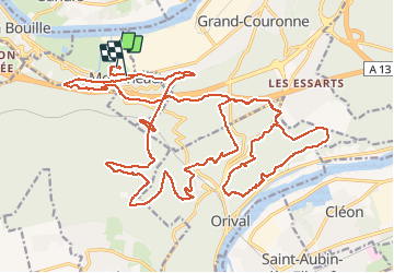
Tocht Mountainbike van 34 km beschikbaar op Normandië, Seine-Maritime, Moulineaux. Deze tocht wordt voorgesteld door tracegps.
Beschrijving
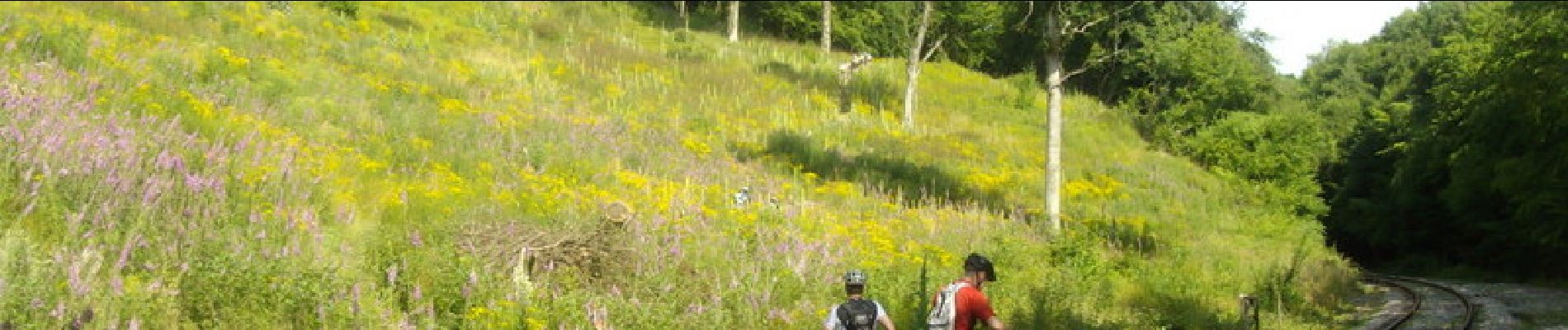
Rando super physique beaucoup de single passage dans une grotte. Prévoir une lampe fixe ou frontale cause passage dans un tunnel ferroviaire désaffecté ou il fait vraiment très noir. Perso j'avais pas prévu de lampe et ça fait un peu bizarre de ne pas voir ou l'on roule(rigolo). A FAIRE ABSOLUMENT, MAGNIFIQUE peut être la plus dure de la région.
Plaatsbepaling
Opmerkingen
Wandeltochten in de omgeving
![Tocht Stappen Hautot-sur-Seine - Hautot-sur-seine 11km - Photo](https://media.geolcdn.com/t/375/260/2e225eeb-e814-4a2c-a540-ca57c244afd9.jpg&format=jpg&maxdim=2)
![Stappen Stappen](https://static1.geolcdn.com/sitytour/trail-icons/101.png)
Stappen
![](/images/other/stat-length.png)
![](https://static1.geolcdn.com/siteimages/upload/files/16400158638029165_repeat_loop_refresh_sync_direction_icon.png)
![Tocht Stappen La Londe - La Londe 76- 13 km - Photo](https://media.geolcdn.com/t/375/260/23588b19-2689-475f-b2bd-10608cbf7253.jpg&format=jpg&maxdim=2)
![Stappen Stappen](https://static1.geolcdn.com/sitytour/trail-icons/101.png)
Stappen
![](/images/other/stat-length.png)
![](https://static1.geolcdn.com/siteimages/upload/files/16400158638029165_repeat_loop_refresh_sync_direction_icon.png)
![Tocht Stappen Moulineaux - Robert-le-Diable - château - GD - V2 - Photo](https://media.geolcdn.com/t/375/260/ext.jpg?maxdim=2&url=https%3A%2F%2Fstatic1.geolcdn.com%2Fsiteimages%2Fupload%2Ffiles%2F1553511878bg_sport_marche.png)
![Stappen Stappen](https://static1.geolcdn.com/sitytour/trail-icons/101.png)
Stappen
![](/images/other/stat-length.png)
![](https://static1.geolcdn.com/siteimages/upload/files/16400158638029165_repeat_loop_refresh_sync_direction_icon.png)
![Stappen Stappen](https://static1.geolcdn.com/sitytour/trail-icons/101.png)
Stappen
![](/images/other/stat-length.png)
![](https://static1.geolcdn.com/siteimages/upload/files/16400158638029165_repeat_loop_refresh_sync_direction_icon.png)
![Stappen Stappen](https://static1.geolcdn.com/sitytour/trail-icons/101.png)
Stappen
![](/images/other/stat-length.png)
![](https://static1.geolcdn.com/siteimages/upload/files/16400158638029165_repeat_loop_refresh_sync_direction_icon.png)
![Tocht Stappen La Bouille - La Bouille- Cote Albert Lambert-Robert le Diable - Photo](https://media.geolcdn.com/t/375/260/6619d219-dc7a-4ef0-85ef-d79a78fa0fb8.jpg&format=jpg&maxdim=2)
![Stappen Stappen](https://static1.geolcdn.com/sitytour/trail-icons/101.png)
Stappen
![](/images/other/stat-length.png)
![](https://static1.geolcdn.com/siteimages/upload/files/16400158638029165_repeat_loop_refresh_sync_direction_icon.png)
![Tocht Stappen Moulineaux - 20240227-Moulineaux Cool - Photo](https://media.geolcdn.com/t/375/260/3ac6da5d-fb2e-4aeb-8862-80cdf7511849.jpg&format=jpg&maxdim=2)
![Stappen Stappen](https://static1.geolcdn.com/sitytour/trail-icons/101.png)
Stappen
![](/images/other/stat-length.png)
![](https://static1.geolcdn.com/siteimages/upload/files/16400158638029165_repeat_loop_refresh_sync_direction_icon.png)
![Stappen Stappen](https://static1.geolcdn.com/sitytour/trail-icons/101.png)
Stappen
![](/images/other/stat-length.png)
![](https://static1.geolcdn.com/siteimages/upload/files/16400158638029165_repeat_loop_refresh_sync_direction_icon.png)
![Tocht Stappen Sahurs - 20231216-sahurs - Photo](https://media.geolcdn.com/t/375/260/6157c822-41a3-4d46-8844-2a9e1019e224.jpg&format=jpg&maxdim=2)
![Stappen Stappen](https://static1.geolcdn.com/sitytour/trail-icons/101.png)
Stappen
![](/images/other/stat-length.png)
![](https://static1.geolcdn.com/siteimages/upload/files/16400158638029165_repeat_loop_refresh_sync_direction_icon.png)