![](/images/other/stat-length.png)
![Tocht Stappen Saverne - Circulaire du Saut du Prince Charles - Photo](https://media.geolcdn.com/t/1900/400/ext.pjpeg?maxdim=2&url=https%3A%2F%2Fservices.sitytrail.com%2FGeolivesWS%2FDownloadMedia.ashx%3FTrailID%3D103332%26Media%3D5336_2.jpg)
Circulaire du Saut du Prince Charles
tracegps
Gebruiker
![Lengte](/images/other/stat-length.png)
![Max. hoogte](https://static1.geolcdn.com/siteimages/upload/files/1508320355ic_sort_altitude_max_24dp.png)
![Positief hoogteverschil](https://static1.geolcdn.com/siteimages/upload/files/1508320355ic_sort_den_pos_24dp.png)
![Km-Effort](/images/other/stat-length.png)
![Min. hoogte](https://static1.geolcdn.com/siteimages/upload/files/1508320355ic_sort_altitude_min_24dp.png)
![Negatief hoogteverschil](https://static1.geolcdn.com/siteimages/upload/files/1508320355ic_sort_den_neg_24dp.png)
![Boucle](https://static1.geolcdn.com/siteimages/upload/files/16400158638029165_repeat_loop_refresh_sync_direction_icon.png)
![Stappen](https://static1.geolcdn.com/sitytour/trail-icons/101.png)
2h00
Moeilijkheid : Medium
![Scan deze QR-code om de tocht te openen in de SityTrail-applicatie](https://capi.geolives.com/qq0zvz2zws4bq2lad0pu/sitytour/trails/103332/qr.png?size=200)
Gratisgps-wandelapplicatie
Over ons
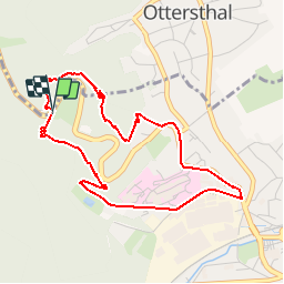
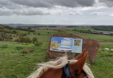
Tocht Stappen van 4,3 km beschikbaar op Grand Est, Bas-Rhin, Saverne. Deze tocht wordt voorgesteld door tracegps.
Beschrijving
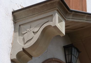
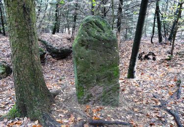
Très sympa... Se garer au parking du jardin botanique de saverne. Le Saut du Prince Charles: il s'agit d'un rocher d'une dizaine de mètres de hauteur, du haut duquel un cavalier aurait jadis sauté avec son cheval pour échapper à ses poursuivants. Il reste de cet exploit la marque des fers du cheval, gravée à jamais dans le roc où l'animal a atterri, et que l'on voit sur la carte ci-après. Le Prince Charles dont il s'agit pourrait être Charles IV, duc de Lorraine, qui a guerroyé dans la région durant la Guerre de Trente Ans (1618-1648). (source Thierry Heitmann)
Plaatsbepaling
Opmerkingen
Wandeltochten in de omgeving
![Tocht Mountainbike Saverne - Tour du Brotsch - Saverne - Photo](https://media.geolcdn.com/t/375/260/ext.jpg?maxdim=2&url=https%3A%2F%2Fservices.sitytrail.com%2FGeolivesWS%2FDownloadMedia.ashx%3FTrailID%3D105879%26Media%3D9858_4.jpg)
![Mountainbike Mountainbike](https://static1.geolcdn.com/sitytour/trail-icons/202.png)
Mountainbike
![](/images/other/stat-length.png)
![](https://static1.geolcdn.com/siteimages/upload/files/16400158638029165_repeat_loop_refresh_sync_direction_icon.png)
![Tocht Stappen Saverne - suuntoapp-Hiking-2025-01-26T10-25-17Z - Photo](https://media.geolcdn.com/t/375/260/66df0327-39b7-45a8-a8e4-88255af586df.jpg&format=jpg&maxdim=2)
![Stappen Stappen](https://static1.geolcdn.com/sitytour/trail-icons/101.png)
Stappen
![](/images/other/stat-length.png)
![](https://static1.geolcdn.com/siteimages/upload/files/16400158638029165_repeat_loop_refresh_sync_direction_icon.png)
![Tocht Te voet Ernolsheim-lès-Saverne - Rectangle bleu barré de blanc - Photo](https://media.geolcdn.com/t/375/260/03314272-aa3e-4322-97f6-7afd0207efcf.jpeg&format=jpg&maxdim=2)
![Te voet Te voet](https://static1.geolcdn.com/sitytour/trail-icons/100.png)
Te voet
![](/images/other/stat-length.png)
![](https://static1.geolcdn.com/siteimages/upload/files/16400158638029165_repeat_loop_refresh_sync_direction_icon.png)
![Tocht Te voet Ernolsheim-lès-Saverne - Anneau jaune - Photo](https://media.geolcdn.com/t/375/260/3cb28aaa-d36b-490a-bf7b-0a37964c9ea6.jpeg&format=jpg&maxdim=2)
![Te voet Te voet](https://static1.geolcdn.com/sitytour/trail-icons/100.png)
Te voet
![](/images/other/stat-length.png)
![](https://static1.geolcdn.com/siteimages/upload/files/16400158638029165_repeat_loop_refresh_sync_direction_icon.png)
![Tocht Te voet Saint-Jean-Saverne - Chevalet rouge - Photo](https://media.geolcdn.com/t/375/260/0dd39903-a686-40c3-9785-4ead1bbebc8f.jpeg&format=jpg&maxdim=2)
![Te voet Te voet](https://static1.geolcdn.com/sitytour/trail-icons/100.png)
Te voet
![](/images/other/stat-length.png)
![](https://static1.geolcdn.com/siteimages/upload/files/16400158638029165_repeat_loop_refresh_sync_direction_icon.png)
![Tocht Te voet Saint-Jean-Saverne - Circuit Archéologique d'Ernolsheim-lès-Saverne - Photo](https://media.geolcdn.com/t/375/260/60c6095c-d8e2-44d1-91f6-754fc6d8b002.jpeg&format=jpg&maxdim=2)
![Te voet Te voet](https://static1.geolcdn.com/sitytour/trail-icons/100.png)
Te voet
![](/images/other/stat-length.png)
![](https://static1.geolcdn.com/siteimages/upload/files/16400158638029165_repeat_loop_refresh_sync_direction_icon.png)
![Tocht Te voet Saint-Jean-Saverne - Circuit du Frohnberg - Photo](https://media.geolcdn.com/t/375/260/7f477f52-186a-47be-97f3-d4b05d97d596.jpeg&format=jpg&maxdim=2)
![Te voet Te voet](https://static1.geolcdn.com/sitytour/trail-icons/100.png)
Te voet
![](/images/other/stat-length.png)
![](https://static1.geolcdn.com/siteimages/upload/files/16400158638029165_repeat_loop_refresh_sync_direction_icon.png)
![Tocht Te voet Saint-Jean-Saverne - Circuit de la Forêt des Dames - Photo](https://media.geolcdn.com/t/375/260/940f4f7a-5ffe-4be9-a519-9b1fc81fa3eb.jpeg&format=jpg&maxdim=2)
![Te voet Te voet](https://static1.geolcdn.com/sitytour/trail-icons/100.png)
Te voet
![](/images/other/stat-length.png)
![](https://static1.geolcdn.com/siteimages/upload/files/16400158638029165_repeat_loop_refresh_sync_direction_icon.png)
![Tocht Paardrijden Ernolsheim-lès-Saverne - 2019-10-09 Rando CVA Boucle du Bastberg - Photo](https://media.geolcdn.com/t/375/260/72578a99-81ce-4cc9-afb5-cf575fecba1c.jpg&format=jpg&maxdim=2)
![Paardrijden Paardrijden](https://static1.geolcdn.com/sitytour/trail-icons/301.png)
Paardrijden
![](/images/other/stat-length.png)
![](https://static1.geolcdn.com/siteimages/upload/files/16400158638029165_repeat_loop_refresh_sync_direction_icon.png)