![](/images/other/stat-length.png)
![Tocht Mountainbike Sexey-aux-Forges - Rando Sexey aux Forges - Photo](https://media.geolcdn.com/t/1900/400/ext.pjpeg?maxdim=2&url=https%3A%2F%2Fstatic1.geolcdn.com%2Fsiteimages%2Fupload%2Ffiles%2F1524743154velo.jpg)
Rando Sexey aux Forges
tracegps
Gebruiker
![Lengte](/images/other/stat-length.png)
Lengte
51 km
![Max. hoogte](https://static1.geolcdn.com/siteimages/upload/files/1508320355ic_sort_altitude_max_24dp.png)
Max. hoogte
399 m
![Positief hoogteverschil](https://static1.geolcdn.com/siteimages/upload/files/1508320355ic_sort_den_pos_24dp.png)
Positief hoogteverschil
848 m
![Km-Effort](/images/other/stat-length.png)
Km-Effort
62 km
![Min. hoogte](https://static1.geolcdn.com/siteimages/upload/files/1508320355ic_sort_altitude_min_24dp.png)
Min. hoogte
210 m
![Negatief hoogteverschil](https://static1.geolcdn.com/siteimages/upload/files/1508320355ic_sort_den_neg_24dp.png)
Negatief hoogteverschil
847 m
![Boucle](https://static1.geolcdn.com/siteimages/upload/files/16400158638029165_repeat_loop_refresh_sync_direction_icon.png)
Boucle
Ja
Datum van aanmaak :
2014-12-10 00:00:00.0
Laatste wijziging :
2014-12-10 00:00:00.0
![Mountainbike](https://static1.geolcdn.com/sitytour/trail-icons/202.png)
3h30
Moeilijkheid : Moeilijk
![Scan deze QR-code om de tocht te openen in de SityTrail-applicatie](https://capi.geolives.com/qq0zvz2zws4bq2lad0pu/sitytour/trails/103320/qr.png?size=200)
Gratisgps-wandelapplicatie
Over ons
Tocht Mountainbike van 51 km beschikbaar op Grand Est, Meurthe-et-Moselle, Sexey-aux-Forges. Deze tocht wordt voorgesteld door tracegps.
Beschrijving
Magnifique randonnée organisé par FOYER RURAL VTT SEXEY AUX FORGES le 03 mai 2009 52 Kms que dans les bois sur de magnifiques chemins et sentiers.
Plaatsbepaling
Land:
France
Regio :
Grand Est
Departement/Provincie :
Meurthe-et-Moselle
Gemeente :
Sexey-aux-Forges
Locatie:
Unknown
Vertrek:(Dec)
Vertrek:(UTM)
283017 ; 5389532 (32U) N.
Opmerkingen
Wandeltochten in de omgeving
![Tocht Stappen Bainville-sur-Madon - Bainville sur Madon - Photo](https://media.geolcdn.com/t/375/260/ext.jpg?maxdim=2&url=https%3A%2F%2Fstatic1.geolcdn.com%2Fsiteimages%2Fupload%2Ffiles%2F1553511878bg_sport_marche.png)
![Stappen Stappen](https://static1.geolcdn.com/sitytour/trail-icons/101.png)
Bainville sur Madon
Stappen
Medium
(3)
Bainville-sur-Madon,
Grand Est,
Meurthe-et-Moselle,
France
![](/images/other/stat-length.png)
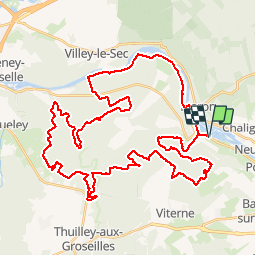
18,3 km | 23 km-effort
4h 15min
![](https://static1.geolcdn.com/siteimages/upload/files/16400158638029165_repeat_loop_refresh_sync_direction_icon.png)
Ja
![Tocht Stappen Villers-lès-Nancy - RANDO DUO AVEC ALEXIS - Photo](https://media.geolcdn.com/t/375/260/ext.jpg?maxdim=2&url=https%3A%2F%2Fstatic1.geolcdn.com%2Fsiteimages%2Fupload%2Ffiles%2F1553511878bg_sport_marche.png)
![Stappen Stappen](https://static1.geolcdn.com/sitytour/trail-icons/101.png)
RANDO DUO AVEC ALEXIS
Stappen
Moeilijk
(1)
Villers-lès-Nancy,
Grand Est,
Meurthe-et-Moselle,
France
![](/images/other/stat-length.png)
38 km | 45 km-effort
10h 19min
![](https://static1.geolcdn.com/siteimages/upload/files/16400158638029165_repeat_loop_refresh_sync_direction_icon.png)
Neen
![Tocht Stappen Sexey-aux-Forges - Sexey Aux Forges - Photo](https://media.geolcdn.com/t/375/260/b5abff6f-2c34-417b-95da-67ff19f21fe9.jpg&format=jpg&maxdim=2)
![Stappen Stappen](https://static1.geolcdn.com/sitytour/trail-icons/101.png)
Sexey Aux Forges
Stappen
Zeer moeilijk
Sexey-aux-Forges,
Grand Est,
Meurthe-et-Moselle,
France
![](/images/other/stat-length.png)
31 km | 38 km-effort
2h 38min
![](https://static1.geolcdn.com/siteimages/upload/files/16400158638029165_repeat_loop_refresh_sync_direction_icon.png)
Neen
![Tocht Stappen Bainville-sur-Madon - BAINVILLE SUR MADON - CIRCUIT VOIVRE ET JACQUES CALLOT - Photo](https://media.geolcdn.com/t/375/260/71b1e74d-91cb-4458-89e0-3ec0ae2fe5ca.jpg&format=jpg&maxdim=2)
![Stappen Stappen](https://static1.geolcdn.com/sitytour/trail-icons/101.png)
BAINVILLE SUR MADON - CIRCUIT VOIVRE ET JACQUES CALLOT
Stappen
Medium
Bainville-sur-Madon,
Grand Est,
Meurthe-et-Moselle,
France
![](/images/other/stat-length.png)
19,8 km | 24 km-effort
5h 44min
![](https://static1.geolcdn.com/siteimages/upload/files/16400158638029165_repeat_loop_refresh_sync_direction_icon.png)
Ja
![Tocht Stappen Viterne - sentier des croix - Photo](https://media.geolcdn.com/t/375/260/ext.jpg?maxdim=2&url=https%3A%2F%2Fstatic1.geolcdn.com%2Fsiteimages%2Fupload%2Ffiles%2F1553511878bg_sport_marche.png)
![Stappen Stappen](https://static1.geolcdn.com/sitytour/trail-icons/101.png)
sentier des croix
Stappen
Heel gemakkelijk
(1)
Viterne,
Grand Est,
Meurthe-et-Moselle,
France
![](/images/other/stat-length.png)
11,6 km | 13,6 km-effort
3h 10min
![](https://static1.geolcdn.com/siteimages/upload/files/16400158638029165_repeat_loop_refresh_sync_direction_icon.png)
Ja
![Tocht Stappen Maizières - viterne du 14.12.2013 - Photo](https://media.geolcdn.com/t/375/260/ext.jpg?maxdim=2&url=https%3A%2F%2Fservices.sitytrail.com%2FGeolivesWS%2FDownloadMedia.ashx%3FTrailID%3D237300%26Media%3Dfix__20131214133915.jpg)
![Stappen Stappen](https://static1.geolcdn.com/sitytour/trail-icons/101.png)
viterne du 14.12.2013
Stappen
Gemakkelijk
(2)
Maizières,
Grand Est,
Meurthe-et-Moselle,
France
![](/images/other/stat-length.png)
7,6 km | 9,5 km-effort
2h 6min
![](https://static1.geolcdn.com/siteimages/upload/files/16400158638029165_repeat_loop_refresh_sync_direction_icon.png)
Neen
![Tocht Stappen Chaligny - Chaligny 1 - Photo](https://media.geolcdn.com/t/375/260/ext.jpg?maxdim=2&url=https%3A%2F%2Fstatic1.geolcdn.com%2Fsiteimages%2Fupload%2Ffiles%2F1553511878bg_sport_marche.png)
![Stappen Stappen](https://static1.geolcdn.com/sitytour/trail-icons/101.png)
Chaligny 1
Stappen
Gemakkelijk
(1)
Chaligny,
Grand Est,
Meurthe-et-Moselle,
France
![](/images/other/stat-length.png)
4,9 km | 6,3 km-effort
1h 20min
![](https://static1.geolcdn.com/siteimages/upload/files/16400158638029165_repeat_loop_refresh_sync_direction_icon.png)
Ja
![Tocht Stappen Maizières - Randoguide - Photo](https://media.geolcdn.com/t/375/260/ext.jpg?maxdim=2&url=https%3A%2F%2Fstatic1.geolcdn.com%2Fsiteimages%2Fupload%2Ffiles%2F1553511878bg_sport_marche.png)
![Stappen Stappen](https://static1.geolcdn.com/sitytour/trail-icons/101.png)
Randoguide
Stappen
Medium
(2)
Maizières,
Grand Est,
Meurthe-et-Moselle,
France
![](/images/other/stat-length.png)
9,4 km | 12,9 km-effort
2h 19min
![](https://static1.geolcdn.com/siteimages/upload/files/16400158638029165_repeat_loop_refresh_sync_direction_icon.png)
Ja
![Tocht Stappen Viterne - viterne circuits des croix - Photo](https://media.geolcdn.com/t/375/260/cc80a7d9-f957-4e3c-9254-c439850d7f38.jpg&format=jpg&maxdim=2)
![Stappen Stappen](https://static1.geolcdn.com/sitytour/trail-icons/101.png)
viterne circuits des croix
Stappen
Moeilijk
Viterne,
Grand Est,
Meurthe-et-Moselle,
France
![](/images/other/stat-length.png)
12,3 km | 14,3 km-effort
3h 10min
![](https://static1.geolcdn.com/siteimages/upload/files/16400158638029165_repeat_loop_refresh_sync_direction_icon.png)
Ja