![](/images/other/stat-length.png)
![Tocht Stappen Lignereuil - Lignereuil Allée des tilleuls - Blavincourt - Denier - Photo](https://media.geolcdn.com/t/1900/400/ext.pjpeg?maxdim=2&url=https%3A%2F%2Fstatic1.geolcdn.com%2Fsiteimages%2Fupload%2Ffiles%2F1553511878bg_sport_marche.png)
Lignereuil Allée des tilleuls - Blavincourt - Denier
tracegps
Gebruiker
![Lengte](/images/other/stat-length.png)
Lengte
11,2 km
![Max. hoogte](https://static1.geolcdn.com/siteimages/upload/files/1508320355ic_sort_altitude_max_24dp.png)
Max. hoogte
154 m
![Positief hoogteverschil](https://static1.geolcdn.com/siteimages/upload/files/1508320355ic_sort_den_pos_24dp.png)
Positief hoogteverschil
111 m
![Km-Effort](/images/other/stat-length.png)
Km-Effort
12,7 km
![Min. hoogte](https://static1.geolcdn.com/siteimages/upload/files/1508320355ic_sort_altitude_min_24dp.png)
Min. hoogte
110 m
![Negatief hoogteverschil](https://static1.geolcdn.com/siteimages/upload/files/1508320355ic_sort_den_neg_24dp.png)
Negatief hoogteverschil
113 m
![Boucle](https://static1.geolcdn.com/siteimages/upload/files/16400158638029165_repeat_loop_refresh_sync_direction_icon.png)
Boucle
Ja
Datum van aanmaak :
2014-12-10 00:00:00.0
Laatste wijziging :
2014-12-10 00:00:00.0
![Stappen](https://static1.geolcdn.com/sitytour/trail-icons/101.png)
2h00
Moeilijkheid : Medium
![Scan deze QR-code om de tocht te openen in de SityTrail-applicatie](https://capi.geolives.com/qq0zvz2zws4bq2lad0pu/sitytour/trails/103250/qr.png?size=200)
Gratisgps-wandelapplicatie
Over ons
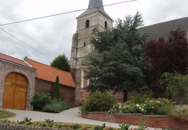
Tocht Stappen van 11,2 km beschikbaar op Hauts-de-France, Pas-de-Calais, Lignereuil. Deze tocht wordt voorgesteld door tracegps.
Beschrijving
Randonnée du club Arras Inter Génération du 9 avril 2009. Très belle randonnée qui emprunte l'allée des tilleuls de Lignereuil à Gigenchy le Noble.
Plaatsbepaling
Land:
France
Regio :
Hauts-de-France
Departement/Provincie :
Pas-de-Calais
Gemeente :
Lignereuil
Locatie:
Unknown
Vertrek:(Dec)
Vertrek:(UTM)
462462 ; 5570975 (31U) N.
Opmerkingen
Wandeltochten in de omgeving
![Tocht Mountainbike Avesnes-le-Comte - Les 6 châteaux - Avesnes le Comte - Photo](https://media.geolcdn.com/t/375/260/ext.jpg?maxdim=2&url=https%3A%2F%2Fstatic1.geolcdn.com%2Fsiteimages%2Fupload%2Ffiles%2F1524743154velo.jpg)
![Mountainbike Mountainbike](https://static1.geolcdn.com/sitytour/trail-icons/202.png)
Les 6 châteaux - Avesnes le Comte
Mountainbike
Moeilijk
(1)
Avesnes-le-Comte,
Hauts-de-France,
Pas-de-Calais,
France
![](/images/other/stat-length.png)
44 km | 50 km-effort
2h 10min
![](https://static1.geolcdn.com/siteimages/upload/files/16400158638029165_repeat_loop_refresh_sync_direction_icon.png)
Ja
![Tocht Stappen Penin - Chemin des piedsentes (Penin) - Photo](https://media.geolcdn.com/t/375/260/ext.jpg?maxdim=2&url=https%3A%2F%2Fservices.sitytrail.com%2FGeolivesWS%2FDownloadMedia.ashx%3FTrailID%3D109845%26Media%3D4816_2.jpg)
![Stappen Stappen](https://static1.geolcdn.com/sitytour/trail-icons/101.png)
Chemin des piedsentes (Penin)
Stappen
Moeilijk
Penin,
Hauts-de-France,
Pas-de-Calais,
France
![](/images/other/stat-length.png)
14,5 km | 15,7 km-effort
3h 40min
![](https://static1.geolcdn.com/siteimages/upload/files/16400158638029165_repeat_loop_refresh_sync_direction_icon.png)
Ja
![Tocht Stappen Berlencourt-le-Cauroy - Le sentier du loup (Berlencourt-le-cauroy) - Photo](https://media.geolcdn.com/t/375/260/ext.jpg?maxdim=2&url=https%3A%2F%2Fservices.sitytrail.com%2FGeolivesWS%2FDownloadMedia.ashx%3FTrailID%3D109827%26Media%3D4795_4.jpg)
![Stappen Stappen](https://static1.geolcdn.com/sitytour/trail-icons/101.png)
Le sentier du loup (Berlencourt-le-cauroy)
Stappen
Moeilijk
Berlencourt-le-Cauroy,
Hauts-de-France,
Pas-de-Calais,
France
![](/images/other/stat-length.png)
15,2 km | 17,3 km-effort
3h 45min
![](https://static1.geolcdn.com/siteimages/upload/files/16400158638029165_repeat_loop_refresh_sync_direction_icon.png)
Ja
![Tocht Stappen Lignereuil - LIGNEREUIL (62) - Par le bois du Fay - Photo](https://media.geolcdn.com/t/375/260/ext.jpg?maxdim=2&url=https%3A%2F%2Fmedia.geolcdn.com%2Ff%2Fe01597ee-8b1e-43c0-8cff-a8ed0fa88de1.jpg)
![Stappen Stappen](https://static1.geolcdn.com/sitytour/trail-icons/101.png)
LIGNEREUIL (62) - Par le bois du Fay
Stappen
Moeilijk
Lignereuil,
Hauts-de-France,
Pas-de-Calais,
France
![](/images/other/stat-length.png)
12,1 km | 13,5 km-effort
3h 4min
![](https://static1.geolcdn.com/siteimages/upload/files/16400158638029165_repeat_loop_refresh_sync_direction_icon.png)
Ja
![Tocht Stappen Avesnes-le-Comte - Avesnes le Comte, Noyelle-Vion, Manin, Beaufort-Blavincourt - Photo](https://media.geolcdn.com/t/375/260/ext.jpg?maxdim=2&url=https%3A%2F%2Fservices.sitytrail.com%2FGeolivesWS%2FDownloadMedia.ashx%3FTrailID%3D191466%26Media%3D15058_1.jpg)
![Stappen Stappen](https://static1.geolcdn.com/sitytour/trail-icons/101.png)
Avesnes le Comte, Noyelle-Vion, Manin, Beaufort-Blavincourt
Stappen
Medium
Avesnes-le-Comte,
Hauts-de-France,
Pas-de-Calais,
France
![](/images/other/stat-length.png)
10,8 km | 12,2 km-effort
2h 30min
![](https://static1.geolcdn.com/siteimages/upload/files/16400158638029165_repeat_loop_refresh_sync_direction_icon.png)
Ja
![Tocht Stappen Givenchy-le-Noble - Givenchy le Noble - Ambrines - Denier - Lignereuil - Photo](https://media.geolcdn.com/t/375/260/ext.jpg?maxdim=2&url=https%3A%2F%2Fservices.sitytrail.com%2FGeolivesWS%2FDownloadMedia.ashx%3FTrailID%3D104002%26Media%3D6942_2.jpg)
![Stappen Stappen](https://static1.geolcdn.com/sitytour/trail-icons/101.png)
Givenchy le Noble - Ambrines - Denier - Lignereuil
Stappen
Medium
Givenchy-le-Noble,
Hauts-de-France,
Pas-de-Calais,
France
![](/images/other/stat-length.png)
11 km | 12,5 km-effort
2h 0min
![](https://static1.geolcdn.com/siteimages/upload/files/16400158638029165_repeat_loop_refresh_sync_direction_icon.png)
Ja
![Tocht Mountainbike Avesnes-le-Comte - Les six châteaux - Photo](https://media.geolcdn.com/t/375/260/ext.jpg?maxdim=2&url=https%3A%2F%2Fstatic1.geolcdn.com%2Fsiteimages%2Fupload%2Ffiles%2F1524743154velo.jpg)
![Mountainbike Mountainbike](https://static1.geolcdn.com/sitytour/trail-icons/202.png)
Les six châteaux
Mountainbike
Medium
Avesnes-le-Comte,
Hauts-de-France,
Pas-de-Calais,
France
![](/images/other/stat-length.png)
44 km | 50 km-effort
Onbekend
![](https://static1.geolcdn.com/siteimages/upload/files/16400158638029165_repeat_loop_refresh_sync_direction_icon.png)
Ja
![Tocht Stappen Berlencourt-le-Cauroy - Berlencourt/Lucheux 23Kms Dén P 266m - Photo](https://media.geolcdn.com/t/375/260/ext.jpg?maxdim=2&url=https%3A%2F%2Fstatic1.geolcdn.com%2Fsiteimages%2Fupload%2Ffiles%2F1553511878bg_sport_marche.png)
![Stappen Stappen](https://static1.geolcdn.com/sitytour/trail-icons/101.png)
Berlencourt/Lucheux 23Kms Dén P 266m
Stappen
Medium
Berlencourt-le-Cauroy,
Hauts-de-France,
Pas-de-Calais,
France
![](/images/other/stat-length.png)
23 km | 27 km-effort
5h 49min
![](https://static1.geolcdn.com/siteimages/upload/files/16400158638029165_repeat_loop_refresh_sync_direction_icon.png)
Neen
![Tocht Stappen Berlencourt-le-Cauroy - La Cauroy 11.3Kms Dén P 134m - Photo](https://media.geolcdn.com/t/375/260/ext.jpg?maxdim=2&url=https%3A%2F%2Fstatic1.geolcdn.com%2Fsiteimages%2Fupload%2Ffiles%2F1553511878bg_sport_marche.png)
![Stappen Stappen](https://static1.geolcdn.com/sitytour/trail-icons/101.png)
La Cauroy 11.3Kms Dén P 134m
Stappen
Gemakkelijk
Berlencourt-le-Cauroy,
Hauts-de-France,
Pas-de-Calais,
France
![](/images/other/stat-length.png)
11,5 km | 13,2 km-effort
2h 54min
![](https://static1.geolcdn.com/siteimages/upload/files/16400158638029165_repeat_loop_refresh_sync_direction_icon.png)
Ja