![](/images/other/stat-length.png)
![Tocht Mountainbike Montoillot - Les trois châteaux 2018.08.27 - Photo](https://media.geolcdn.com/t/1900/400/ext.pjpeg?maxdim=2&url=https%3A%2F%2Fservices.sitytrail.com%2FGeolivesWS%2FDownloadMedia.ashx%3FTrailID%3D1029756%26Media%3D20180827131143.jpg)
Les trois châteaux 2018.08.27
eric.guyard21
Gebruiker
![Lengte](/images/other/stat-length.png)
![Max. hoogte](https://static1.geolcdn.com/siteimages/upload/files/1508320355ic_sort_altitude_max_24dp.png)
![Positief hoogteverschil](https://static1.geolcdn.com/siteimages/upload/files/1508320355ic_sort_den_pos_24dp.png)
![Km-Effort](/images/other/stat-length.png)
![Min. hoogte](https://static1.geolcdn.com/siteimages/upload/files/1508320355ic_sort_altitude_min_24dp.png)
![Negatief hoogteverschil](https://static1.geolcdn.com/siteimages/upload/files/1508320355ic_sort_den_neg_24dp.png)
![Boucle](https://static1.geolcdn.com/siteimages/upload/files/16400158638029165_repeat_loop_refresh_sync_direction_icon.png)
![Mountainbike](https://static1.geolcdn.com/sitytour/trail-icons/202.png)
1h47
Moeilijkheid : Medium
![Scan deze QR-code om de tocht te openen in de SityTrail-applicatie](https://capi.geolives.com/qq0zvz2zws4bq2lad0pu/sitytour/trails/1029756/qr.png?size=200)
Gratisgps-wandelapplicatie
Over ons
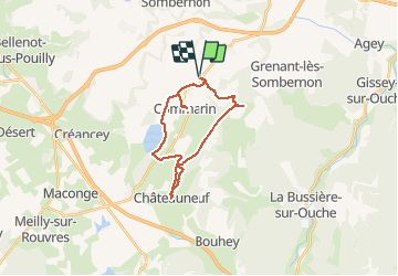
Tocht Mountainbike van 21 km beschikbaar op Bourgondië-Franche-Comté, Côte-d'Or, Montoillot. Deze tocht wordt voorgesteld door eric.guyard21.
Beschrijving
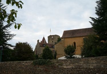
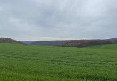
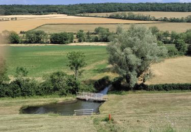
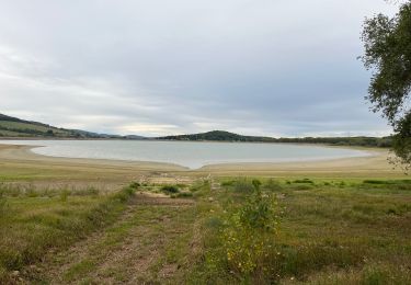
Départ du village de Montoillot, longer la rigole qui alimente le canal de Bourgogne jusqu' au village de Commarin ou vous pourrez découvrir le premier château. Poursuivre en longeant à nouveau la rigole pour arriver au réservoir de Panthier. Longer le réservoir pour arriver au camping, et c'est là que les choses se compliquent.
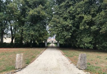
Une montée difficile vous attend pour rejoindre le château de Châteauneuf.
Vous pourrez aller jusqu'à la croix avec une vue magnifique.
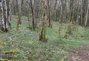
poursuivre en traversant les bois en direction du troisième château ou vous croiserez deux ours. Un petit peu de route et vous arriverez au château de L'Oiserolle.
Une grande descente et c'est l'arrivée à Montoilot.
Plaatsbepaling
Opmerkingen
Wandeltochten in de omgeving
![Tocht Te voet Montoillot - Boucle des Trois Châteaux - Photo](https://media.geolcdn.com/t/375/260/2cd4cd43-eb70-46bd-8967-9dc616d3cc69.jpeg&format=jpg&maxdim=2)
![Te voet Te voet](https://static1.geolcdn.com/sitytour/trail-icons/100.png)
Te voet
![](/images/other/stat-length.png)
![](https://static1.geolcdn.com/siteimages/upload/files/16400158638029165_repeat_loop_refresh_sync_direction_icon.png)
![Tocht Stappen Civry-en-Montagne - Civet en montagne - Photo](https://media.geolcdn.com/t/375/260/dd662309-f8c4-4a8d-9db5-5b89765dbfc9.jpg&format=jpg&maxdim=2)
![Stappen Stappen](https://static1.geolcdn.com/sitytour/trail-icons/101.png)
Stappen
![](/images/other/stat-length.png)
![](https://static1.geolcdn.com/siteimages/upload/files/16400158638029165_repeat_loop_refresh_sync_direction_icon.png)
![Tocht Stappen Grenant-lès-Sombernon - Grenant les sombernon - Photo](https://media.geolcdn.com/t/375/260/df59c81b-a7ed-408e-9f72-9695d8a9e535.jpg&format=jpg&maxdim=2)
![Stappen Stappen](https://static1.geolcdn.com/sitytour/trail-icons/101.png)
Stappen
![](/images/other/stat-length.png)
![](https://static1.geolcdn.com/siteimages/upload/files/16400158638029165_repeat_loop_refresh_sync_direction_icon.png)
![Tocht Mountainbike Montoillot - Les trois châteaux 2018.08.27 - Photo](https://media.geolcdn.com/t/375/260/ext.jpg?maxdim=2&url=https%3A%2F%2Fservices.sitytrail.com%2FGeolivesWS%2FDownloadMedia.ashx%3FTrailID%3D1029771%26Media%3D20180827131143.jpg)
![Mountainbike Mountainbike](https://static1.geolcdn.com/sitytour/trail-icons/202.png)
Mountainbike
![](/images/other/stat-length.png)
![](https://static1.geolcdn.com/siteimages/upload/files/16400158638029165_repeat_loop_refresh_sync_direction_icon.png)
![Tocht Stappen Vandenesse-en-Auxois - panthiers - Photo](https://media.geolcdn.com/t/375/260/14c65ebe-b6ca-40db-b603-89beb453f7f3.jpg&format=jpg&maxdim=2)
![Stappen Stappen](https://static1.geolcdn.com/sitytour/trail-icons/101.png)
Stappen
![](/images/other/stat-length.png)
![](https://static1.geolcdn.com/siteimages/upload/files/16400158638029165_repeat_loop_refresh_sync_direction_icon.png)
![Tocht Stappen Commarin - Départ panthier - Photo](https://media.geolcdn.com/t/375/260/2b638803-4ddf-4f12-8e48-17c7401a4ed0.jpg&format=jpg&maxdim=2)
![Stappen Stappen](https://static1.geolcdn.com/sitytour/trail-icons/101.png)
Stappen
![](/images/other/stat-length.png)
![](https://static1.geolcdn.com/siteimages/upload/files/16400158638029165_repeat_loop_refresh_sync_direction_icon.png)
![Tocht Mountainbike Montoillot - Les trois cha^teaux 2018.08.27 - Photo](https://media.geolcdn.com/t/375/260/ext.jpg?maxdim=2&url=https%3A%2F%2Fservices.sitytrail.com%2FGeolivesWS%2FDownloadMedia.ashx%3FTrailID%3D1029723%26Media%3D20180827131143.jpg)
![Mountainbike Mountainbike](https://static1.geolcdn.com/sitytour/trail-icons/202.png)
Mountainbike
![](/images/other/stat-length.png)
![](https://static1.geolcdn.com/siteimages/upload/files/16400158638029165_repeat_loop_refresh_sync_direction_icon.png)
![Tocht Stappen Montoillot - la boucle des 3 châteaux en auxois (Dijon) - Photo](https://media.geolcdn.com/t/375/260/ext.jpg?maxdim=2&url=https%3A%2F%2Fstatic1.geolcdn.com%2Fsiteimages%2Fupload%2Ffiles%2F1553511878bg_sport_marche.png)
![Stappen Stappen](https://static1.geolcdn.com/sitytour/trail-icons/101.png)
Stappen
![](/images/other/stat-length.png)
![](https://static1.geolcdn.com/siteimages/upload/files/16400158638029165_repeat_loop_refresh_sync_direction_icon.png)
![Tocht Lopen Grenant-lès-Sombernon - jogging 1 - Photo](https://media.geolcdn.com/t/375/260/ext.jpg?maxdim=2&url=https%3A%2F%2Fstatic1.geolcdn.com%2Fsiteimages%2Fupload%2Ffiles%2F1524743154running.jpg)
![Lopen Lopen](https://static1.geolcdn.com/sitytour/trail-icons/103.png)
Lopen
![](/images/other/stat-length.png)
![](https://static1.geolcdn.com/siteimages/upload/files/16400158638029165_repeat_loop_refresh_sync_direction_icon.png)