![](/images/other/stat-length.png)
![Tocht Mountainbike Wissembourg - Traversée du Massif Vosgien - Photo](https://media.geolcdn.com/t/1900/400/ext.pjpeg?maxdim=2&url=https%3A%2F%2Fstatic1.geolcdn.com%2Fsiteimages%2Fupload%2Ffiles%2F1524743154velo.jpg)
Traversée du Massif Vosgien
tracegps
Gebruiker
![Lengte](/images/other/stat-length.png)
![Max. hoogte](https://static1.geolcdn.com/siteimages/upload/files/1508320355ic_sort_altitude_max_24dp.png)
![Positief hoogteverschil](https://static1.geolcdn.com/siteimages/upload/files/1508320355ic_sort_den_pos_24dp.png)
![Km-Effort](/images/other/stat-length.png)
![Min. hoogte](https://static1.geolcdn.com/siteimages/upload/files/1508320355ic_sort_altitude_min_24dp.png)
![Negatief hoogteverschil](https://static1.geolcdn.com/siteimages/upload/files/1508320355ic_sort_den_neg_24dp.png)
![Boucle](https://static1.geolcdn.com/siteimages/upload/files/16400158638029165_repeat_loop_refresh_sync_direction_icon.png)
![Mountainbike](https://static1.geolcdn.com/sitytour/trail-icons/202.png)
192h00
Moeilijkheid : Moeilijk
![Scan deze QR-code om de tocht te openen in de SityTrail-applicatie](https://capi.geolives.com/qq0zvz2zws4bq2lad0pu/sitytour/trails/102888/qr.png?size=200)
Gratisgps-wandelapplicatie
Over ons
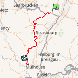
Tocht Mountainbike van 393 km beschikbaar op Grand Est, Bas-Rhin, Wissembourg. Deze tocht wordt voorgesteld door tracegps.
Beschrijving
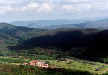
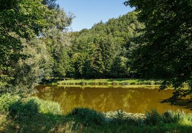
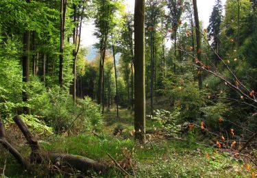
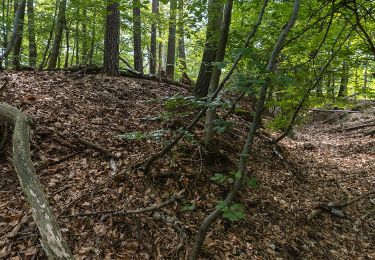
De Wissembourg à Thann, vous roulerez dans le parc régional des Vosges du nord ainsi que le parc naturel régional des ballons d’Alsace, tout en traversant le piémont des Vosges. Cet itinéraire permanent est jalonné par des villes, villages, fermes auberges, curiosités locales, lacs et escales panoramiques. De difficultés physique et technique différentes, cette traversée emprunte des passages à flanc de collines, des chemins traversant vallées et forêts. Expert, confirmé, débutant ou famille trouveront dans cette traversée une large palette de sensations, de découvertes ou simplement du bonheur.
Plaatsbepaling
Opmerkingen
Wandeltochten in de omgeving
![Tocht Te voet Wissembourg - Rotes Kreuz - Photo](https://media.geolcdn.com/t/375/260/68ad6046-667d-4bda-b0a1-354cff9d940f.jpeg&format=jpg&maxdim=2)
![Te voet Te voet](https://static1.geolcdn.com/sitytour/trail-icons/100.png)
Te voet
![](/images/other/stat-length.png)
![](https://static1.geolcdn.com/siteimages/upload/files/16400158638029165_repeat_loop_refresh_sync_direction_icon.png)
![Tocht Te voet Wissembourg - Disque vert - Photo](https://media.geolcdn.com/t/375/260/99623353-36c3-423c-a751-656a0e168277.jpeg&format=jpg&maxdim=2)
![Te voet Te voet](https://static1.geolcdn.com/sitytour/trail-icons/100.png)
Te voet
![](/images/other/stat-length.png)
![](https://static1.geolcdn.com/siteimages/upload/files/16400158638029165_repeat_loop_refresh_sync_direction_icon.png)
![Tocht Te voet Wissembourg - Anneau rouge - Photo](https://media.geolcdn.com/t/375/260/55a6a0a6-0f10-4437-aabb-c766882fbdd8.jpeg&format=jpg&maxdim=2)
![Te voet Te voet](https://static1.geolcdn.com/sitytour/trail-icons/100.png)
Te voet
![](/images/other/stat-length.png)
![](https://static1.geolcdn.com/siteimages/upload/files/16400158638029165_repeat_loop_refresh_sync_direction_icon.png)
![Tocht Te voet Wissembourg - Anneau vert - Photo](https://media.geolcdn.com/t/375/260/899751ba-5eaf-46ca-aeea-7f1e26b78d37.jpeg&format=jpg&maxdim=2)
![Te voet Te voet](https://static1.geolcdn.com/sitytour/trail-icons/100.png)
Te voet
![](/images/other/stat-length.png)
![](https://static1.geolcdn.com/siteimages/upload/files/16400158638029165_repeat_loop_refresh_sync_direction_icon.png)
![Tocht Te voet Dörrenbach - Weg der Aussichten, Dörrenbach - Photo](https://media.geolcdn.com/t/375/260/ef1a6a3b-6757-4ea4-a794-b6e50608a517.jpeg&format=jpg&maxdim=2)
![Te voet Te voet](https://static1.geolcdn.com/sitytour/trail-icons/100.png)
Te voet
![](/images/other/stat-length.png)
![](https://static1.geolcdn.com/siteimages/upload/files/16400158638029165_repeat_loop_refresh_sync_direction_icon.png)
![Tocht Te voet Schweigen-Rechtenbach - Rund ums Steinbühl Schweigen-Rechtenbach - Photo](https://media.geolcdn.com/t/375/260/918f5ff8-7ace-428c-9e42-3f204543353a.jpeg&format=jpg&maxdim=2)
![Te voet Te voet](https://static1.geolcdn.com/sitytour/trail-icons/100.png)
Te voet
![](/images/other/stat-length.png)
![](https://static1.geolcdn.com/siteimages/upload/files/16400158638029165_repeat_loop_refresh_sync_direction_icon.png)
![Tocht Te voet Schweigen-Rechtenbach - Ruine Guttenberg Tour Schweigen-Rechtenbach - Photo](https://media.geolcdn.com/t/375/260/fffbdcab-7fb1-4aea-81a4-e93247296b54.jpeg&format=jpg&maxdim=2)
![Te voet Te voet](https://static1.geolcdn.com/sitytour/trail-icons/100.png)
Te voet
![](/images/other/stat-length.png)
![](https://static1.geolcdn.com/siteimages/upload/files/16400158638029165_repeat_loop_refresh_sync_direction_icon.png)
![Tocht Te voet Wissembourg - Grenzland Tour Schweigen-Rechtenbach - Photo](https://media.geolcdn.com/t/375/260/bd736793-f493-4f0d-8fb5-8a1c3d8aadfb.jpeg&format=jpg&maxdim=2)
![Te voet Te voet](https://static1.geolcdn.com/sitytour/trail-icons/100.png)
Te voet
![](/images/other/stat-length.png)
![](https://static1.geolcdn.com/siteimages/upload/files/16400158638029165_repeat_loop_refresh_sync_direction_icon.png)
![Tocht Te voet Oberotterbach - Weg der Geschichte, Oberotterbach - Photo](https://media.geolcdn.com/t/375/260/612ddb44-dd60-4898-8629-e66921918ec9.jpeg&format=jpg&maxdim=2)
![Te voet Te voet](https://static1.geolcdn.com/sitytour/trail-icons/100.png)
Te voet
![](/images/other/stat-length.png)
![](https://static1.geolcdn.com/siteimages/upload/files/16400158638029165_repeat_loop_refresh_sync_direction_icon.png)