![](/images/other/stat-length.png)
![Tocht Stappen Ternant-les-Eaux - Dauzat sur Vodable - Photo](https://media.geolcdn.com/t/1900/400/ext.pjpeg?maxdim=2&url=https%3A%2F%2Fservices.sitytrail.com%2FGeolivesWS%2FDownloadMedia.ashx%3FTrailID%3D102854%26Media%3D4028_3.jpg)
Dauzat sur Vodable
tracegps
Gebruiker
![Lengte](/images/other/stat-length.png)
![Max. hoogte](https://static1.geolcdn.com/siteimages/upload/files/1508320355ic_sort_altitude_max_24dp.png)
![Positief hoogteverschil](https://static1.geolcdn.com/siteimages/upload/files/1508320355ic_sort_den_pos_24dp.png)
![Km-Effort](/images/other/stat-length.png)
![Min. hoogte](https://static1.geolcdn.com/siteimages/upload/files/1508320355ic_sort_altitude_min_24dp.png)
![Negatief hoogteverschil](https://static1.geolcdn.com/siteimages/upload/files/1508320355ic_sort_den_neg_24dp.png)
![Boucle](https://static1.geolcdn.com/siteimages/upload/files/16400158638029165_repeat_loop_refresh_sync_direction_icon.png)
![Stappen](https://static1.geolcdn.com/sitytour/trail-icons/101.png)
3h15
Moeilijkheid : Moeilijk
![Scan deze QR-code om de tocht te openen in de SityTrail-applicatie](https://capi.geolives.com/qq0zvz2zws4bq2lad0pu/sitytour/trails/102854/qr.png?size=200)
Gratisgps-wandelapplicatie
Over ons
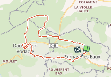
Tocht Stappen van 10,8 km beschikbaar op Auvergne-Rhône-Alpes, Puy-de-Dôme, Ternant-les-Eaux. Deze tocht wordt voorgesteld door tracegps.
Beschrijving
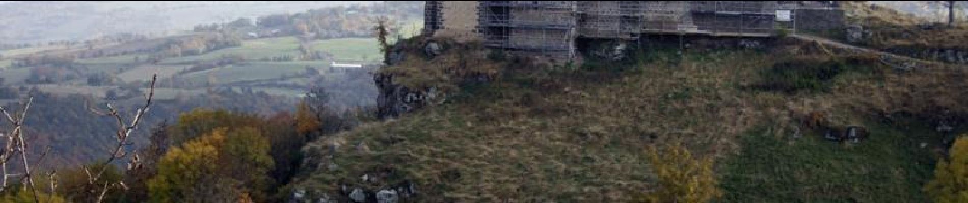
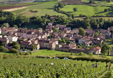
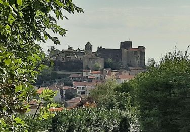
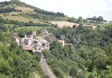
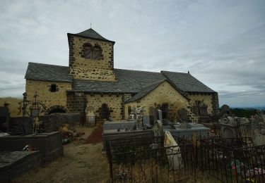
Belle balade depuis Ternant-Les-Eaux où, sur le couderc,le four à pain le puit et la fontaine ont été restaurés avec goût (le couderc ou codère, en langue d'Oc,est un espace herbeux près des habitations autour duquel s'est constitué petit à petit le village). Le marcheur et amateur des vieilles pierres et d'Histoire sera comblé par la vue, à mi-parcours près de Dauzat sur Vodable, de la belle et massive église paroissiale perchée sur un dyke, construite aux XIIe et XIIIe siècles et actuellement en restauration. Balade numérisée sur le terrain par Jean louis Phillipart. Retrouvez cette randonnée dans le topo Guide Chamina Lembron.
Plaatsbepaling
Opmerkingen
Wandeltochten in de omgeving
![Tocht Stappen Boudes - Boudes_Cheminees_Fees - Photo](https://media.geolcdn.com/t/375/260/2d6f9b52-9afa-4443-acb4-142ca3c3881a.jpg&format=jpg&maxdim=2)
![Stappen Stappen](https://static1.geolcdn.com/sitytour/trail-icons/101.png)
Stappen
![](/images/other/stat-length.png)
![](https://static1.geolcdn.com/siteimages/upload/files/16400158638029165_repeat_loop_refresh_sync_direction_icon.png)
![Tocht Stappen Boudes - Boudes_Vallee_Saints - Photo](https://media.geolcdn.com/t/375/260/75dcab49-0943-405f-9b02-ddf9cf506eea.jpg&format=jpg&maxdim=2)
![Stappen Stappen](https://static1.geolcdn.com/sitytour/trail-icons/101.png)
Stappen
![](/images/other/stat-length.png)
![](https://static1.geolcdn.com/siteimages/upload/files/16400158638029165_repeat_loop_refresh_sync_direction_icon.png)
![Tocht Stappen Villeneuve - Villeneuve_Boudes_Chalus - Photo](https://media.geolcdn.com/t/375/260/fa4d9ad2-0c04-4754-942b-a8352fff5676.jpg&format=jpg&maxdim=2)
![Stappen Stappen](https://static1.geolcdn.com/sitytour/trail-icons/101.png)
Stappen
![](/images/other/stat-length.png)
![](https://static1.geolcdn.com/siteimages/upload/files/16400158638029165_repeat_loop_refresh_sync_direction_icon.png)
![Tocht Stappen Boudes - Boudes_Coteaux - Photo](https://media.geolcdn.com/t/375/260/84417786-618e-40d7-80a8-c68612090218.jpg&format=jpg&maxdim=2)
![Stappen Stappen](https://static1.geolcdn.com/sitytour/trail-icons/101.png)
Stappen
![](/images/other/stat-length.png)
![](https://static1.geolcdn.com/siteimages/upload/files/16400158638029165_repeat_loop_refresh_sync_direction_icon.png)
![Tocht Te voet Boudes - Villeneuve, Boudes, Chalus - Photo](https://media.geolcdn.com/t/375/260/9a83dcb2-377f-43a0-8436-358d4c634f72.jpeg&format=jpg&maxdim=2)
![Te voet Te voet](https://static1.geolcdn.com/sitytour/trail-icons/100.png)
Te voet
![](/images/other/stat-length.png)
![](https://static1.geolcdn.com/siteimages/upload/files/16400158638029165_repeat_loop_refresh_sync_direction_icon.png)
![Tocht Te voet Madriat - Bard et Letz - Photo](https://media.geolcdn.com/t/375/260/e7b4e9aa-8c72-4cfb-b241-a0f535763702.jpeg&format=jpg&maxdim=2)
![Te voet Te voet](https://static1.geolcdn.com/sitytour/trail-icons/100.png)
Te voet
![](/images/other/stat-length.png)
![](https://static1.geolcdn.com/siteimages/upload/files/16400158638029165_repeat_loop_refresh_sync_direction_icon.png)
![Tocht Te voet Boudes - La Vallee des Saints - Photo](https://media.geolcdn.com/t/375/260/8b5212f5-c0d3-403b-b77d-cbcbaaa74e95.jpeg&format=jpg&maxdim=2)
![Te voet Te voet](https://static1.geolcdn.com/sitytour/trail-icons/100.png)
Te voet
![](/images/other/stat-length.png)
![](https://static1.geolcdn.com/siteimages/upload/files/16400158638029165_repeat_loop_refresh_sync_direction_icon.png)
![Tocht Te voet Mareugheol - La Chaux et le Bois de Jaby - Photo](https://media.geolcdn.com/t/375/260/d7ed3937-d9f3-475d-9b76-187d38d4bf46.jpeg&format=jpg&maxdim=2)
![Te voet Te voet](https://static1.geolcdn.com/sitytour/trail-icons/100.png)
Te voet
![](/images/other/stat-length.png)
![](https://static1.geolcdn.com/siteimages/upload/files/16400158638029165_repeat_loop_refresh_sync_direction_icon.png)
![Tocht Te voet Dauzat-sur-Vodable - Dauzat-sur-Vodable - Photo](https://media.geolcdn.com/t/375/260/d172e481-65da-4881-bd03-f6cc99def315.jpeg&format=jpg&maxdim=2)
![Te voet Te voet](https://static1.geolcdn.com/sitytour/trail-icons/100.png)
Te voet
![](/images/other/stat-length.png)
![](https://static1.geolcdn.com/siteimages/upload/files/16400158638029165_repeat_loop_refresh_sync_direction_icon.png)