![](/images/other/stat-length.png)
![Tocht Mountainbike Nazelles-Négron - Vision de la Touraine autour de Nazelles Négron - Photo](https://media.geolcdn.com/t/1900/400/ext.pjpeg?maxdim=2&url=https%3A%2F%2Fservices.sitytrail.com%2FGeolivesWS%2FDownloadMedia.ashx%3FTrailID%3D102830%26Media%3D3993_6.jpg)
Vision de la Touraine autour de Nazelles Négron
tracegps
Gebruiker
![Lengte](/images/other/stat-length.png)
![Max. hoogte](https://static1.geolcdn.com/siteimages/upload/files/1508320355ic_sort_altitude_max_24dp.png)
![Positief hoogteverschil](https://static1.geolcdn.com/siteimages/upload/files/1508320355ic_sort_den_pos_24dp.png)
![Km-Effort](/images/other/stat-length.png)
![Min. hoogte](https://static1.geolcdn.com/siteimages/upload/files/1508320355ic_sort_altitude_min_24dp.png)
![Negatief hoogteverschil](https://static1.geolcdn.com/siteimages/upload/files/1508320355ic_sort_den_neg_24dp.png)
![Boucle](https://static1.geolcdn.com/siteimages/upload/files/16400158638029165_repeat_loop_refresh_sync_direction_icon.png)
![Mountainbike](https://static1.geolcdn.com/sitytour/trail-icons/202.png)
3h15
Moeilijkheid : Moeilijk
![Scan deze QR-code om de tocht te openen in de SityTrail-applicatie](https://capi.geolives.com/qq0zvz2zws4bq2lad0pu/sitytour/trails/102830/qr.png?size=200)
Gratisgps-wandelapplicatie
Over ons
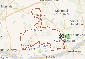
Tocht Mountainbike van 100 km beschikbaar op Centre-Val de Loire, Indre-et-Loire, Nazelles-Négron. Deze tocht wordt voorgesteld door tracegps.
Beschrijving
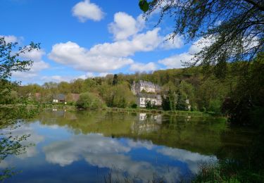
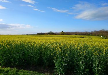
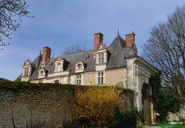
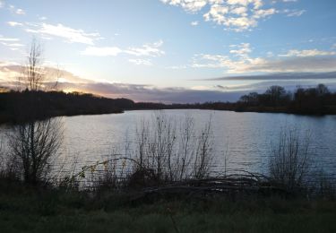
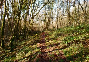
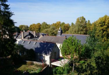
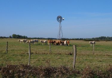
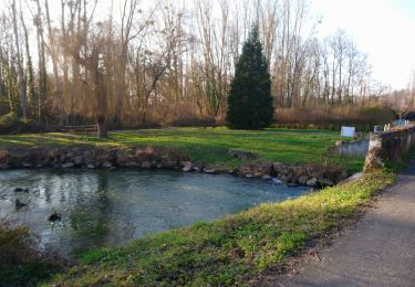
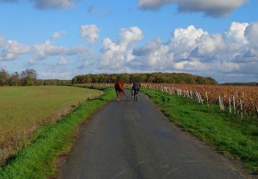
Voici une petite rando qui vous permettra d’avoir un aperçu des paysages et de l’habitat tourangeau. Vous pourrez voir des champs, des vignes, de très belles longères et quelques petits châteaux. Vous pourrez aussi vous rendre constater que le pays n’est pas si plat que ça. Très belle promenade.
Plaatsbepaling
Opmerkingen
Wandeltochten in de omgeving
![Tocht Stappen Pocé-sur-Cisse - Pocé-sur-Cisse - Saint-Ouen-les-Vignes - 17km 305m 3h45 (35mn) - 2024 04 10 - Photo](https://media.geolcdn.com/t/375/260/40530b85-1831-4d54-bee3-88999e7b680f.jpg&format=jpg&maxdim=2)
![Stappen Stappen](https://static1.geolcdn.com/sitytour/trail-icons/101.png)
Stappen
![](/images/other/stat-length.png)
![](https://static1.geolcdn.com/siteimages/upload/files/16400158638029165_repeat_loop_refresh_sync_direction_icon.png)
![Tocht Stappen Nazelles-Négron - Nazelles-Négron - Zig zag autour de Nazelles et de Pocé-sur-Cisse - 18.1km 340m 4h05 - 2024 03 24 - Photo](https://media.geolcdn.com/t/375/260/b4c80bca-e974-478d-aff9-0771f417e572.jpg&format=jpg&maxdim=2)
![Stappen Stappen](https://static1.geolcdn.com/sitytour/trail-icons/101.png)
Stappen
![](/images/other/stat-length.png)
![](https://static1.geolcdn.com/siteimages/upload/files/16400158638029165_repeat_loop_refresh_sync_direction_icon.png)
![Tocht Stappen Noizay - Noizay - Zig zag autour des Coteaux à l'est de Noizay - 21.3km 370m 5h00 (40mn) - 2024 03 20 - Photo](https://media.geolcdn.com/t/375/260/6f5cee46-8120-45a7-a457-5ad832f22807.jpg&format=jpg&maxdim=2)
![Stappen Stappen](https://static1.geolcdn.com/sitytour/trail-icons/101.png)
Stappen
![](/images/other/stat-length.png)
![](https://static1.geolcdn.com/siteimages/upload/files/16400158638029165_repeat_loop_refresh_sync_direction_icon.png)
![Tocht Stappen Amboise - Amboise - variante PR Hors des sentiers battus - 13.2km 125m 2h45 - 2023 12 20 - Photo](https://media.geolcdn.com/t/375/260/eaedd70a-7314-4305-8a66-377c6d47d376.jpg&format=jpg&maxdim=2)
![Stappen Stappen](https://static1.geolcdn.com/sitytour/trail-icons/101.png)
Stappen
![](/images/other/stat-length.png)
![](https://static1.geolcdn.com/siteimages/upload/files/16400158638029165_repeat_loop_refresh_sync_direction_icon.png)
![Tocht Stappen Nazelles-Négron - Nazelles-Négron - variante PR Circuit Val Plateau - 10.6km 125m 2h25 (40mn) - 2023 12 20 - Photo](https://media.geolcdn.com/t/375/260/db197c9d-ca81-4840-908b-9a2fe7566a1d.jpg&format=jpg&maxdim=2)
![Stappen Stappen](https://static1.geolcdn.com/sitytour/trail-icons/101.png)
Stappen
![](/images/other/stat-length.png)
![](https://static1.geolcdn.com/siteimages/upload/files/16400158638029165_repeat_loop_refresh_sync_direction_icon.png)
![Tocht Stappen Lussault-sur-Loire - Lussault-sur-Loire - Grille Dorée Pagode de Chanteloup - 15.1km 160m 3h15 - 2023 10 11 - Photo](https://media.geolcdn.com/t/375/260/49886bf8-2556-4f8b-ac9a-489bf75e23bb.jpg&format=jpg&maxdim=2)
![Stappen Stappen](https://static1.geolcdn.com/sitytour/trail-icons/101.png)
Stappen
![](/images/other/stat-length.png)
![](https://static1.geolcdn.com/siteimages/upload/files/16400158638029165_repeat_loop_refresh_sync_direction_icon.png)
![Tocht Stappen Nazelles-Négron - Nazelles-Négron - variante PR Circuit Val Village de Négron - 8.3km 40m 1h50 (40mn) - 2023 10 11 - Photo](https://media.geolcdn.com/t/375/260/a8cef7b4-e79b-4337-9586-e14374732695.jpg&format=jpg&maxdim=2)
![Stappen Stappen](https://static1.geolcdn.com/sitytour/trail-icons/101.png)
Stappen
![](/images/other/stat-length.png)
![](https://static1.geolcdn.com/siteimages/upload/files/16400158638029165_repeat_loop_refresh_sync_direction_icon.png)
![Tocht Stappen Noizay - la Bousserie - Noizay - 14km 100m 3h00 - 2023 02 12 - Photo](https://media.geolcdn.com/t/375/260/e82473dd-70b3-426f-8e44-9d257c621d06.jpg&format=jpg&maxdim=2)
![Stappen Stappen](https://static1.geolcdn.com/sitytour/trail-icons/101.png)
Stappen
![](/images/other/stat-length.png)
![](https://static1.geolcdn.com/siteimages/upload/files/16400158638029165_repeat_loop_refresh_sync_direction_icon.png)
![Tocht Stappen Noizay - Noizay - Carcou Vernou via PRs Chançay - 24.7km 290m 5h20 (30mn) - 2022 11 19 - Photo](https://media.geolcdn.com/t/375/260/2672b0f2-49c2-42ff-9714-49118cac5701.jpg&format=jpg&maxdim=2)
![Stappen Stappen](https://static1.geolcdn.com/sitytour/trail-icons/101.png)
Stappen
![](/images/other/stat-length.png)
![](https://static1.geolcdn.com/siteimages/upload/files/16400158638029165_repeat_loop_refresh_sync_direction_icon.png)