![](/images/other/stat-length.png)
![Tocht Fiets Le Mérévillois - Méréville de la Juine à la Marette de Guillerval - Photo](https://media.geolcdn.com/t/1900/400/ext.pjpeg?maxdim=2&url=https%3A%2F%2Fstatic1.geolcdn.com%2Fsiteimages%2Fupload%2Ffiles%2F1524743154velo.jpg)
Méréville de la Juine à la Marette de Guillerval
tracegps
Gebruiker
![Lengte](/images/other/stat-length.png)
Lengte
21 km
![Max. hoogte](https://static1.geolcdn.com/siteimages/upload/files/1508320355ic_sort_altitude_max_24dp.png)
Max. hoogte
141 m
![Positief hoogteverschil](https://static1.geolcdn.com/siteimages/upload/files/1508320355ic_sort_den_pos_24dp.png)
Positief hoogteverschil
278 m
![Km-Effort](/images/other/stat-length.png)
Km-Effort
25 km
![Min. hoogte](https://static1.geolcdn.com/siteimages/upload/files/1508320355ic_sort_altitude_min_24dp.png)
Min. hoogte
79 m
![Negatief hoogteverschil](https://static1.geolcdn.com/siteimages/upload/files/1508320355ic_sort_den_neg_24dp.png)
Negatief hoogteverschil
278 m
![Boucle](https://static1.geolcdn.com/siteimages/upload/files/16400158638029165_repeat_loop_refresh_sync_direction_icon.png)
Boucle
Ja
Datum van aanmaak :
2014-12-10 00:00:00.0
Laatste wijziging :
2014-12-10 00:00:00.0
![Fiets](https://static1.geolcdn.com/sitytour/trail-icons/200.png)
1h30
Moeilijkheid : Medium
![Scan deze QR-code om de tocht te openen in de SityTrail-applicatie](https://capi.geolives.com/qq0zvz2zws4bq2lad0pu/sitytour/trails/102762/qr.png?size=200)
Gratisgps-wandelapplicatie
Over ons
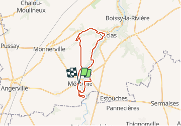
Tocht Fiets van 21 km beschikbaar op Île-de-France, Essonne, Le Mérévillois. Deze tocht wordt voorgesteld door tracegps.
Beschrijving
Méréville de la Juine à la Marette de Guillerval Par la route de la vallée, on rejoint Garsenval, Guillerval et Saclas. Puis on suit la Juine par la Croix St Aignan, la Tour Trajane et retour. Balade proposée par Tourisme Essonne.
Plaatsbepaling
Land:
France
Regio :
Île-de-France
Departement/Provincie :
Essonne
Gemeente :
Le Mérévillois
Locatie:
Méréville
Vertrek:(Dec)
Vertrek:(UTM)
432276 ; 5351718 (31U) N.
Opmerkingen
Wandeltochten in de omgeving
![Tocht Stappen Le Mérévillois - Cressonnières et domaine départemental de Méréville - Photo](https://media.geolcdn.com/t/375/260/2d976ddb-4942-4108-b044-4564b8620dab.jpg&format=jpg&maxdim=2)
![Stappen Stappen](https://static1.geolcdn.com/sitytour/trail-icons/101.png)
Cressonnières et domaine départemental de Méréville
Stappen
Heel gemakkelijk
Le Mérévillois,
Île-de-France,
Essonne,
France
![](/images/other/stat-length.png)
22 km | 25 km-effort
4h 51min
![](https://static1.geolcdn.com/siteimages/upload/files/16400158638029165_repeat_loop_refresh_sync_direction_icon.png)
Ja
![Tocht Mountainbike Saclas - vtt2 - Photo](https://media.geolcdn.com/t/375/260/ext.jpg?maxdim=2&url=https%3A%2F%2Fstatic1.geolcdn.com%2Fsiteimages%2Fupload%2Ffiles%2F1524743154velo.jpg)
![Mountainbike Mountainbike](https://static1.geolcdn.com/sitytour/trail-icons/202.png)
vtt2
Mountainbike
Gemakkelijk
(1)
Saclas,
Île-de-France,
Essonne,
France
![](/images/other/stat-length.png)
4,9 km | 5,7 km-effort
Onbekend
![](https://static1.geolcdn.com/siteimages/upload/files/16400158638029165_repeat_loop_refresh_sync_direction_icon.png)
Ja
![Tocht Stappen Le Mérévillois - Méréville le long des cressonnières de la Juine - Photo](https://media.geolcdn.com/t/375/260/ext.jpg?maxdim=2&url=https%3A%2F%2Fservices.sitytrail.com%2FGeolivesWS%2FDownloadMedia.ashx%3FTrailID%3D102858%26Media%3D4034_3.jpg)
![Stappen Stappen](https://static1.geolcdn.com/sitytour/trail-icons/101.png)
Méréville le long des cressonnières de la Juine
Stappen
Medium
Le Mérévillois,
Île-de-France,
Essonne,
France
![](/images/other/stat-length.png)
10 km | 11,8 km-effort
3h 0min
![](https://static1.geolcdn.com/siteimages/upload/files/16400158638029165_repeat_loop_refresh_sync_direction_icon.png)
Ja
![Tocht Stappen Le Mérévillois - mereville - Photo](https://media.geolcdn.com/t/375/260/ext.jpg?maxdim=2&url=https%3A%2F%2Fstatic1.geolcdn.com%2Fsiteimages%2Fupload%2Ffiles%2F1553511878bg_sport_marche.png)
![Stappen Stappen](https://static1.geolcdn.com/sitytour/trail-icons/101.png)
mereville
Stappen
Zeer moeilijk
Le Mérévillois,
Île-de-France,
Essonne,
France
![](/images/other/stat-length.png)
22 km | 26 km-effort
5h 57min
![](https://static1.geolcdn.com/siteimages/upload/files/16400158638029165_repeat_loop_refresh_sync_direction_icon.png)
Ja
![Tocht Mountainbike Saclas - vtt 1 - Photo](https://media.geolcdn.com/t/375/260/ext.jpg?maxdim=2&url=https%3A%2F%2Fstatic1.geolcdn.com%2Fsiteimages%2Fupload%2Ffiles%2F1524743154velo.jpg)
![Mountainbike Mountainbike](https://static1.geolcdn.com/sitytour/trail-icons/202.png)
vtt 1
Mountainbike
Heel gemakkelijk
Saclas,
Île-de-France,
Essonne,
France
![](/images/other/stat-length.png)
7,3 km | 8,8 km-effort
Onbekend
![](https://static1.geolcdn.com/siteimages/upload/files/16400158638029165_repeat_loop_refresh_sync_direction_icon.png)
Ja
![Tocht Stappen Le Mérévillois - ormoy mereville - Photo](https://media.geolcdn.com/t/375/260/ext.jpg?maxdim=2&url=https%3A%2F%2Fstatic1.geolcdn.com%2Fsiteimages%2Fupload%2Ffiles%2F1553511878bg_sport_marche.png)
![Stappen Stappen](https://static1.geolcdn.com/sitytour/trail-icons/101.png)
ormoy mereville
Stappen
Zeer moeilijk
Le Mérévillois,
Île-de-France,
Essonne,
France
![](/images/other/stat-length.png)
28 km | 33 km-effort
7h 24min
![](https://static1.geolcdn.com/siteimages/upload/files/16400158638029165_repeat_loop_refresh_sync_direction_icon.png)
Neen
![Tocht Te voet Le Mérévillois - Mérévillle à Ormoy-la-Rivière + les cressonières - Photo](https://media.geolcdn.com/t/375/260/ext.jpg?maxdim=2&url=https%3A%2F%2Fstatic1.geolcdn.com%2Fsiteimages%2Fupload%2Ffiles%2F1545311037marcheuse_200dpi.jpg)
![Te voet Te voet](https://static1.geolcdn.com/sitytour/trail-icons/100.png)
Mérévillle à Ormoy-la-Rivière + les cressonières
Te voet
Moeilijk
(1)
Le Mérévillois,
Île-de-France,
Essonne,
France
![](/images/other/stat-length.png)
28 km | 34 km-effort
7h 47min
![](https://static1.geolcdn.com/siteimages/upload/files/16400158638029165_repeat_loop_refresh_sync_direction_icon.png)
Neen
![Tocht Stappen Le Mérévillois - De Méréville à Ormoy-la-Rivière - Photo](https://media.geolcdn.com/t/375/260/ext.jpg?maxdim=2&url=https%3A%2F%2Fstatic1.geolcdn.com%2Fsiteimages%2Fupload%2Ffiles%2F1553511878bg_sport_marche.png)
![Stappen Stappen](https://static1.geolcdn.com/sitytour/trail-icons/101.png)
De Méréville à Ormoy-la-Rivière
Stappen
Zeer moeilijk
Le Mérévillois,
Île-de-France,
Essonne,
France
![](/images/other/stat-length.png)
22 km | 26 km-effort
5h 59min
![](https://static1.geolcdn.com/siteimages/upload/files/16400158638029165_repeat_loop_refresh_sync_direction_icon.png)
Neen
![Tocht Stappen Le Mérévillois - 2024-05-15 Rando Méréville - Photo](https://media.geolcdn.com/t/375/260/ext.jpg?maxdim=2&url=https%3A%2F%2Fstatic1.geolcdn.com%2Fsiteimages%2Fupload%2Ffiles%2F1553511878bg_sport_marche.png)
![Stappen Stappen](https://static1.geolcdn.com/sitytour/trail-icons/101.png)
2024-05-15 Rando Méréville
Stappen
Gemakkelijk
Le Mérévillois,
Île-de-France,
Essonne,
France
![](/images/other/stat-length.png)
15,5 km | 18,4 km-effort
5h 43min
![](https://static1.geolcdn.com/siteimages/upload/files/16400158638029165_repeat_loop_refresh_sync_direction_icon.png)
Ja