![](/images/other/stat-length.png)
![Tocht Mountainbike Oytier-Saint-Oblas - Boucle autour de Oytier St Oblas - Photo](https://media.geolcdn.com/t/1900/400/ext.pjpeg?maxdim=2&url=https%3A%2F%2Fservices.sitytrail.com%2FGeolivesWS%2FDownloadMedia.ashx%3FTrailID%3D102502%26Media%3D3297_1.jpg)
Boucle autour de Oytier St Oblas
tracegps
Gebruiker
![Lengte](/images/other/stat-length.png)
Lengte
39 km
![Max. hoogte](https://static1.geolcdn.com/siteimages/upload/files/1508320355ic_sort_altitude_max_24dp.png)
Max. hoogte
383 m
![Positief hoogteverschil](https://static1.geolcdn.com/siteimages/upload/files/1508320355ic_sort_den_pos_24dp.png)
Positief hoogteverschil
792 m
![Km-Effort](/images/other/stat-length.png)
Km-Effort
50 km
![Min. hoogte](https://static1.geolcdn.com/siteimages/upload/files/1508320355ic_sort_altitude_min_24dp.png)
Min. hoogte
223 m
![Negatief hoogteverschil](https://static1.geolcdn.com/siteimages/upload/files/1508320355ic_sort_den_neg_24dp.png)
Negatief hoogteverschil
791 m
![Boucle](https://static1.geolcdn.com/siteimages/upload/files/16400158638029165_repeat_loop_refresh_sync_direction_icon.png)
Boucle
Ja
Datum van aanmaak :
2014-12-10 00:00:00.0
Laatste wijziging :
2014-12-10 00:00:00.0
![Mountainbike](https://static1.geolcdn.com/sitytour/trail-icons/202.png)
2h19
Moeilijkheid : Moeilijk
![Scan deze QR-code om de tocht te openen in de SityTrail-applicatie](https://capi.geolives.com/qq0zvz2zws4bq2lad0pu/sitytour/trails/102502/qr.png?size=200)
Gratisgps-wandelapplicatie
Over ons
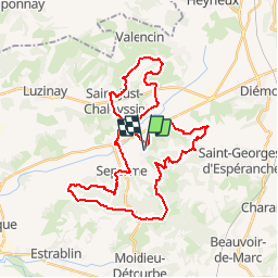
Tocht Mountainbike van 39 km beschikbaar op Auvergne-Rhône-Alpes, Isère, Oytier-Saint-Oblas. Deze tocht wordt voorgesteld door tracegps.
Beschrijving
Parcours technique autour de Oytier St Oblas (38-Isère) alternant passage de route et chemin, dont une partie empruntée a la rando des collines St Georgoises. A éviter après une forte pluie.
Plaatsbepaling
Land:
France
Regio :
Auvergne-Rhône-Alpes
Departement/Provincie :
Isère
Gemeente :
Oytier-Saint-Oblas
Locatie:
Unknown
Vertrek:(Dec)
Vertrek:(UTM)
657604 ; 5047405 (31T) N.
Opmerkingen
Wandeltochten in de omgeving
![Tocht Stappen Saint-Georges-d'Espéranche - rando 20220313 - Photo](https://media.geolcdn.com/t/375/260/7d0ca670-8fe4-4dee-ac55-4a3d633c9682.jpg&format=jpg&maxdim=2)
![Stappen Stappen](https://static1.geolcdn.com/sitytour/trail-icons/101.png)
rando 20220313
Stappen
Gemakkelijk
Saint-Georges-d'Espéranche,
Auvergne-Rhône-Alpes,
Isère,
France
![](/images/other/stat-length.png)
13,7 km | 17,7 km-effort
3h 44min
![](https://static1.geolcdn.com/siteimages/upload/files/16400158638029165_repeat_loop_refresh_sync_direction_icon.png)
Ja
![Tocht Stappen Saint-Georges-d'Espéranche - St Georges 2 - Photo](https://media.geolcdn.com/t/375/260/ext.jpg?maxdim=2&url=https%3A%2F%2Fstatic1.geolcdn.com%2Fsiteimages%2Fupload%2Ffiles%2F1553511878bg_sport_marche.png)
![Stappen Stappen](https://static1.geolcdn.com/sitytour/trail-icons/101.png)
St Georges 2
Stappen
Medium
Saint-Georges-d'Espéranche,
Auvergne-Rhône-Alpes,
Isère,
France
![](/images/other/stat-length.png)
9,1 km | 11,1 km-effort
3h 14min
![](https://static1.geolcdn.com/siteimages/upload/files/16400158638029165_repeat_loop_refresh_sync_direction_icon.png)
Ja
![Tocht Stappen Beauvoir-de-Marc - beauvoir - Photo](https://media.geolcdn.com/t/375/260/ext.jpg?maxdim=2&url=https%3A%2F%2Fstatic1.geolcdn.com%2Fsiteimages%2Fupload%2Ffiles%2F1553511878bg_sport_marche.png)
![Stappen Stappen](https://static1.geolcdn.com/sitytour/trail-icons/101.png)
beauvoir
Stappen
Zeer moeilijk
Beauvoir-de-Marc,
Auvergne-Rhône-Alpes,
Isère,
France
![](/images/other/stat-length.png)
14,8 km | 20 km-effort
4h 33min
![](https://static1.geolcdn.com/siteimages/upload/files/16400158638029165_repeat_loop_refresh_sync_direction_icon.png)
Ja
![Tocht Paardrijden Septème - chteau d'eau Oytier - plaine Moidieu - Photo](https://media.geolcdn.com/t/375/260/ext.jpg?maxdim=2&url=https%3A%2F%2Fstatic1.geolcdn.com%2Fsiteimages%2Fupload%2Ffiles%2F1524743154cheval.jpg)
![Paardrijden Paardrijden](https://static1.geolcdn.com/sitytour/trail-icons/301.png)
chteau d'eau Oytier - plaine Moidieu
Paardrijden
Medium
Septème,
Auvergne-Rhône-Alpes,
Isère,
France
![](/images/other/stat-length.png)
18,9 km | 23 km-effort
2h 35min
![](https://static1.geolcdn.com/siteimages/upload/files/16400158638029165_repeat_loop_refresh_sync_direction_icon.png)
Ja
![Tocht Mountainbike Saint-Just-Chaleyssin - Chaponnay JB 27 05 23 - Photo](https://media.geolcdn.com/t/375/260/ext.jpg?maxdim=2&url=https%3A%2F%2Fstatic1.geolcdn.com%2Fsiteimages%2Fupload%2Ffiles%2F1524743154velo.jpg)
![Mountainbike Mountainbike](https://static1.geolcdn.com/sitytour/trail-icons/202.png)
Chaponnay JB 27 05 23
Mountainbike
Medium
Saint-Just-Chaleyssin,
Auvergne-Rhône-Alpes,
Isère,
France
![](/images/other/stat-length.png)
38 km | 49 km-effort
2h 40min
![](https://static1.geolcdn.com/siteimages/upload/files/16400158638029165_repeat_loop_refresh_sync_direction_icon.png)
Ja
![Tocht Mountainbike Saint-Just-Chaleyssin - St George JB 36 680 - Photo](https://media.geolcdn.com/t/375/260/ext.jpg?maxdim=2&url=https%3A%2F%2Fstatic1.geolcdn.com%2Fsiteimages%2Fupload%2Ffiles%2F1524743154velo.jpg)
![Mountainbike Mountainbike](https://static1.geolcdn.com/sitytour/trail-icons/202.png)
St George JB 36 680
Mountainbike
Medium
Saint-Just-Chaleyssin,
Auvergne-Rhône-Alpes,
Isère,
France
![](/images/other/stat-length.png)
36 km | 45 km-effort
2h 33min
![](https://static1.geolcdn.com/siteimages/upload/files/16400158638029165_repeat_loop_refresh_sync_direction_icon.png)
Ja
![Tocht Paardrijden Oytier-Saint-Oblas - oytier_la combe- péage Septeme - Photo](https://media.geolcdn.com/t/375/260/ext.jpg?maxdim=2&url=https%3A%2F%2Fstatic1.geolcdn.com%2Fsiteimages%2Fupload%2Ffiles%2F1524743154cheval.jpg)
![Paardrijden Paardrijden](https://static1.geolcdn.com/sitytour/trail-icons/301.png)
oytier_la combe- péage Septeme
Paardrijden
Gemakkelijk
Oytier-Saint-Oblas,
Auvergne-Rhône-Alpes,
Isère,
France
![](/images/other/stat-length.png)
12,4 km | 15,4 km-effort
2h 12min
![](https://static1.geolcdn.com/siteimages/upload/files/16400158638029165_repeat_loop_refresh_sync_direction_icon.png)
Ja
![Tocht Mountainbike Saint-Just-Chaleyssin - Septeme long jb 23. 04 - Photo](https://media.geolcdn.com/t/375/260/ext.jpg?maxdim=2&url=https%3A%2F%2Fstatic1.geolcdn.com%2Fsiteimages%2Fupload%2Ffiles%2F1524743154velo.jpg)
![Mountainbike Mountainbike](https://static1.geolcdn.com/sitytour/trail-icons/202.png)
Septeme long jb 23. 04
Mountainbike
Zeer moeilijk
Saint-Just-Chaleyssin,
Auvergne-Rhône-Alpes,
Isère,
France
![](/images/other/stat-length.png)
48 km | 61 km-effort
4h 4min
![](https://static1.geolcdn.com/siteimages/upload/files/16400158638029165_repeat_loop_refresh_sync_direction_icon.png)
Ja
![Tocht Mountainbike Saint-Just-Chaleyssin - VTT jb 13.04.21 - Photo](https://media.geolcdn.com/t/375/260/ext.jpg?maxdim=2&url=https%3A%2F%2Fstatic1.geolcdn.com%2Fsiteimages%2Fupload%2Ffiles%2F1524743154velo.jpg)
![Mountainbike Mountainbike](https://static1.geolcdn.com/sitytour/trail-icons/202.png)
VTT jb 13.04.21
Mountainbike
Zeer moeilijk
Saint-Just-Chaleyssin,
Auvergne-Rhône-Alpes,
Isère,
France
![](/images/other/stat-length.png)
48 km | 60 km-effort
3h 44min
![](https://static1.geolcdn.com/siteimages/upload/files/16400158638029165_repeat_loop_refresh_sync_direction_icon.png)
Ja