![](/images/other/stat-length.png)
![Tocht Fiets Sartène - Ajaccio --> Bonifacio - Etape 5 - Photo](https://media.geolcdn.com/t/1900/400/ext.pjpeg?maxdim=2&url=https%3A%2F%2Fstatic1.geolcdn.com%2Fsiteimages%2Fupload%2Ffiles%2F1524743154velo.jpg)
Ajaccio --> Bonifacio - Etape 5
tracegps
Gebruiker
![Lengte](/images/other/stat-length.png)
![Max. hoogte](https://static1.geolcdn.com/siteimages/upload/files/1508320355ic_sort_altitude_max_24dp.png)
![Positief hoogteverschil](https://static1.geolcdn.com/siteimages/upload/files/1508320355ic_sort_den_pos_24dp.png)
![Km-Effort](/images/other/stat-length.png)
![Min. hoogte](https://static1.geolcdn.com/siteimages/upload/files/1508320355ic_sort_altitude_min_24dp.png)
![Negatief hoogteverschil](https://static1.geolcdn.com/siteimages/upload/files/1508320355ic_sort_den_neg_24dp.png)
![Boucle](https://static1.geolcdn.com/siteimages/upload/files/16400158638029165_repeat_loop_refresh_sync_direction_icon.png)
![Fiets](https://static1.geolcdn.com/sitytour/trail-icons/200.png)
7h00
Moeilijkheid : Moeilijk
![Scan deze QR-code om de tocht te openen in de SityTrail-applicatie](https://capi.geolives.com/qq0zvz2zws4bq2lad0pu/sitytour/trails/102453/qr.png?size=200)
Gratisgps-wandelapplicatie
Over ons
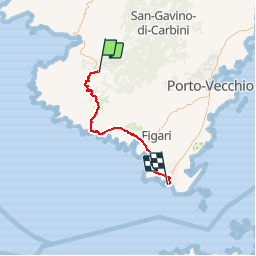
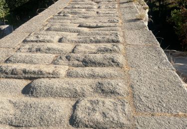
Tocht Fiets van 51 km beschikbaar op Corsica, Corse-du-Sud, Sartène. Deze tocht wordt voorgesteld door tracegps.
Beschrijving
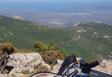
** Etape 5 - Sartène --> Bonifacio ** Longueur cartographique = 51,526 Km Circuit de 158Km utilisant dans la mesure du possible des voies secondaires carrossables dans des paysages côtiers et montagneux superbes. Les 5 étapes sont à titre indicatifs et sont modulables en fonction du physique et des hébergements. Les autres étapes : ** Etape 1 - Ajaccio --> Portigliolo ** Longueur cartographique = 33,288 Km ** Etape 2 - Portigliolo --> Serra-di-Ferro ** Longueur cartographique = 23,259 Km ** Etape 3 - Serra-di-Ferro --> Propriano ** Longueur cartographique = 20,094 Km ** Etape 4 - Propriano --> Sartène ** Longueur cartographique = 30,199 Km
Plaatsbepaling
Opmerkingen
Wandeltochten in de omgeving
![Tocht Stappen Sartène - Visite découverte de Sartène - Photo](https://media.geolcdn.com/t/375/260/ebefb6ab-22aa-4364-8d43-6f5d5917c5b3.jpg&format=jpg&maxdim=2)
![Stappen Stappen](https://static1.geolcdn.com/sitytour/trail-icons/101.png)
Stappen
![](/images/other/stat-length.png)
![](https://static1.geolcdn.com/siteimages/upload/files/16400158638029165_repeat_loop_refresh_sync_direction_icon.png)
![Tocht Stappen Sartène - sardene - Photo](https://media.geolcdn.com/t/375/260/ext.jpg?maxdim=2&url=https%3A%2F%2Fservices.sitytrail.com%2FGeolivesWS%2FDownloadMedia.ashx%3FTrailID%3D151735%26Media%3D20120903162731.jpeg)
![Stappen Stappen](https://static1.geolcdn.com/sitytour/trail-icons/101.png)
Stappen
![](/images/other/stat-length.png)
![](https://static1.geolcdn.com/siteimages/upload/files/16400158638029165_repeat_loop_refresh_sync_direction_icon.png)
![Tocht Stappen Sartène - sardene - Photo](https://media.geolcdn.com/t/375/260/ext.jpg?maxdim=2&url=https%3A%2F%2Fservices.sitytrail.com%2FGeolivesWS%2FDownloadMedia.ashx%3FTrailID%3D151445%26Media%3D20120903132227.jpeg)
![Stappen Stappen](https://static1.geolcdn.com/sitytour/trail-icons/101.png)
Stappen
![](/images/other/stat-length.png)
![](https://static1.geolcdn.com/siteimages/upload/files/16400158638029165_repeat_loop_refresh_sync_direction_icon.png)
![Tocht Trail Sartène - Rizzanese - Photo](https://media.geolcdn.com/t/375/260/349888ee-514d-4c3c-8b11-a074bfb8cba9.jpg&format=jpg&maxdim=2)
![Trail Trail](https://static1.geolcdn.com/sitytour/trail-icons/104.png)
Trail
![](/images/other/stat-length.png)
![](https://static1.geolcdn.com/siteimages/upload/files/16400158638029165_repeat_loop_refresh_sync_direction_icon.png)
![Tocht Stappen Sartène - 20210617 autour de notre maison d’hôtes - Photo](https://media.geolcdn.com/t/375/260/8fe855ca-d142-4452-8c86-4891651e1769.jpg&format=jpg&maxdim=2)
![Stappen Stappen](https://static1.geolcdn.com/sitytour/trail-icons/101.png)
Stappen
![](/images/other/stat-length.png)
![](https://static1.geolcdn.com/siteimages/upload/files/16400158638029165_repeat_loop_refresh_sync_direction_icon.png)
![Tocht Stappen Sartène - 27 mai 21 - Photo](https://media.geolcdn.com/t/375/260/6dd17190-a35f-410b-ab97-5209f38ed554.jpg&format=jpg&maxdim=2)
![Stappen Stappen](https://static1.geolcdn.com/sitytour/trail-icons/101.png)
Stappen
![](/images/other/stat-length.png)
![](https://static1.geolcdn.com/siteimages/upload/files/16400158638029165_repeat_loop_refresh_sync_direction_icon.png)
![Tocht Moto-cross Foce - de Fozzano à Ste Lucie de Tallano - Photo](https://media.geolcdn.com/t/375/260/c7a1b890-af50-4cf7-9e4c-82ca06ffa9a4.jpg&format=jpg&maxdim=2)
![Moto-cross Moto-cross](https://static1.geolcdn.com/sitytour/trail-icons/406.png)
Moto-cross
![](/images/other/stat-length.png)
![](https://static1.geolcdn.com/siteimages/upload/files/16400158638029165_repeat_loop_refresh_sync_direction_icon.png)
![Tocht Moto-cross Foce - de l'Ortolo a l'Ospedale - Photo](https://media.geolcdn.com/t/375/260/97a8c1b3-ac74-41a2-a511-cfa1e5ea8f80.jpg&format=jpg&maxdim=2)
![Moto-cross Moto-cross](https://static1.geolcdn.com/sitytour/trail-icons/406.png)
Moto-cross
![](/images/other/stat-length.png)
![](https://static1.geolcdn.com/siteimages/upload/files/16400158638029165_repeat_loop_refresh_sync_direction_icon.png)
![Tocht Motor Sartène - sartene 2 porto vecchio - Photo](https://media.geolcdn.com/t/375/260/ext.jpg?maxdim=2&url=https%3A%2F%2Fservices.sitytrail.com%2FGeolivesWS%2FDownloadMedia.ashx%3FTrailID%3D151936%26Media%3D20120905153547.jpeg)
![Motor Motor](https://static1.geolcdn.com/sitytour/trail-icons/400.png)
Motor
![](/images/other/stat-length.png)
![](https://static1.geolcdn.com/siteimages/upload/files/16400158638029165_repeat_loop_refresh_sync_direction_icon.png)