![](/images/other/stat-length.png)
![Tocht Mountainbike Labastide-Rouairoux - Voie Verte Mazamet - Bédarieux - Etape 04 - Photo](https://media.geolcdn.com/t/1900/400/ext.pjpeg?maxdim=2&url=https%3A%2F%2Fstatic1.geolcdn.com%2Fsiteimages%2Fupload%2Ffiles%2F1524743154velo.jpg)
Voie Verte Mazamet - Bédarieux - Etape 04
tracegps
Gebruiker
![Lengte](/images/other/stat-length.png)
Lengte
6,5 km
![Max. hoogte](https://static1.geolcdn.com/siteimages/upload/files/1508320355ic_sort_altitude_max_24dp.png)
Max. hoogte
470 m
![Positief hoogteverschil](https://static1.geolcdn.com/siteimages/upload/files/1508320355ic_sort_den_pos_24dp.png)
Positief hoogteverschil
101 m
![Km-Effort](/images/other/stat-length.png)
Km-Effort
7,9 km
![Min. hoogte](https://static1.geolcdn.com/siteimages/upload/files/1508320355ic_sort_altitude_min_24dp.png)
Min. hoogte
378 m
![Negatief hoogteverschil](https://static1.geolcdn.com/siteimages/upload/files/1508320355ic_sort_den_neg_24dp.png)
Negatief hoogteverschil
115 m
![Boucle](https://static1.geolcdn.com/siteimages/upload/files/16400158638029165_repeat_loop_refresh_sync_direction_icon.png)
Boucle
Neen
Datum van aanmaak :
2014-12-10 00:00:00.0
Laatste wijziging :
2014-12-10 00:00:00.0
![Mountainbike](https://static1.geolcdn.com/sitytour/trail-icons/202.png)
45m
Moeilijkheid : Gemakkelijk
![Scan deze QR-code om de tocht te openen in de SityTrail-applicatie](https://capi.geolives.com/qq0zvz2zws4bq2lad0pu/sitytour/trails/102400/qr.png?size=200)
Gratisgps-wandelapplicatie
Over ons
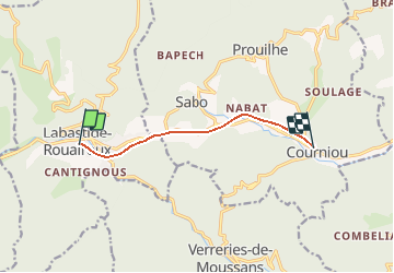
Tocht Mountainbike van 6,5 km beschikbaar op Occitanië, Tarn, Labastide-Rouairoux. Deze tocht wordt voorgesteld door tracegps.
Beschrijving
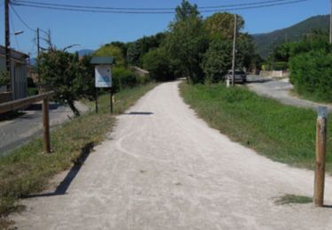
Au cœur du Parc naturel régional, la "piste verte de Mazamet à Bédarieux" est la voie verte du Haut-Languedoc. Cette voie verte est en cours d'aménagement sur l’ancienne voie ferrée.
Plaatsbepaling
Land:
France
Regio :
Occitanië
Departement/Provincie :
Tarn
Gemeente :
Labastide-Rouairoux
Locatie:
Unknown
Vertrek:(Dec)
Vertrek:(UTM)
470695 ; 4813666 (31T) N.
Opmerkingen
Wandeltochten in de omgeving
![Tocht Stappen Lacabarède - Fontaine des 3 Eveques - Photo](https://media.geolcdn.com/t/375/260/ext.jpg?maxdim=2&url=https%3A%2F%2Fstatic1.geolcdn.com%2Fsiteimages%2Fupload%2Ffiles%2F1553511878bg_sport_marche.png)
![Stappen Stappen](https://static1.geolcdn.com/sitytour/trail-icons/101.png)
Fontaine des 3 Eveques
Stappen
Medium
(1)
Lacabarède,
Occitanië,
Tarn,
France
![](/images/other/stat-length.png)
12,9 km | 17,9 km-effort
4h 0min
![](https://static1.geolcdn.com/siteimages/upload/files/16400158638029165_repeat_loop_refresh_sync_direction_icon.png)
Ja
![Tocht Te voet Ferrals-les-Montagnes - Les Hauts de Ferrals - Photo](https://media.geolcdn.com/t/375/260/d8c12b81-5b0d-412e-834e-51aad198b4dc.jpeg&format=jpg&maxdim=2)
![Te voet Te voet](https://static1.geolcdn.com/sitytour/trail-icons/100.png)
Les Hauts de Ferrals
Te voet
Medium
Ferrals-les-Montagnes,
Occitanië,
Hérault,
France
![](/images/other/stat-length.png)
15,4 km | 23 km-effort
5h 18min
![](https://static1.geolcdn.com/siteimages/upload/files/16400158638029165_repeat_loop_refresh_sync_direction_icon.png)
Ja
![Tocht Stappen Courniou - Prouilhe et la Route forestière de la corniche - Photo](https://media.geolcdn.com/t/375/260/1737c856-8ec1-4e24-8a8f-19faf9f767e7.jpg&format=jpg&maxdim=2)
![Stappen Stappen](https://static1.geolcdn.com/sitytour/trail-icons/101.png)
Prouilhe et la Route forestière de la corniche
Stappen
Moeilijk
Courniou,
Occitanië,
Hérault,
France
![](/images/other/stat-length.png)
13,7 km | 22 km-effort
4h 46min
![](https://static1.geolcdn.com/siteimages/upload/files/16400158638029165_repeat_loop_refresh_sync_direction_icon.png)
Ja
![Tocht Stappen Courniou - tunnel de la fenille - Photo](https://media.geolcdn.com/t/375/260/ext.jpg?maxdim=2&url=https%3A%2F%2Fservices.sitytrail.com%2FGeolivesWS%2FDownloadMedia.ashx%3FTrailID%3D193091%26Media%3D8eee1dc4-cb8d-42bd-b098-4fb58815e87f.JPG)
![Stappen Stappen](https://static1.geolcdn.com/sitytour/trail-icons/101.png)
tunnel de la fenille
Stappen
Heel gemakkelijk
Courniou,
Occitanië,
Hérault,
France
![](/images/other/stat-length.png)
3,7 km | 4,2 km-effort
55min
![](https://static1.geolcdn.com/siteimages/upload/files/16400158638029165_repeat_loop_refresh_sync_direction_icon.png)
Neen
![Tocht Mountainbike Labastide-Rouairoux - Grande Traversée de l'Hérault à VTT - itinéraire Sud - de Courniou à Mons la Trivalle - Photo](https://media.geolcdn.com/t/375/260/ext.jpg?maxdim=2&url=https%3A%2F%2Fservices.sitytrail.com%2FGeolivesWS%2FDownloadMedia.ashx%3FTrailID%3D107581%26Media%3D12529_3.jpg)
![Mountainbike Mountainbike](https://static1.geolcdn.com/sitytour/trail-icons/202.png)
Grande Traversée de l'Hérault à VTT - itinéraire Sud - de Courniou à Mons la ...
Mountainbike
Gemakkelijk
Labastide-Rouairoux,
Occitanië,
Tarn,
France
![](/images/other/stat-length.png)
30 km | 37 km-effort
3h 0min
![](https://static1.geolcdn.com/siteimages/upload/files/16400158638029165_repeat_loop_refresh_sync_direction_icon.png)
Neen
![Tocht Stappen Labastide-Rouairoux - Grande Traversée de l'Hérault à VTT - itinéraire Sud - de Courniou à Mons la Trivalle - Photo](https://media.geolcdn.com/t/375/260/ext.jpg?maxdim=2&url=https%3A%2F%2Fservices.sitytrail.com%2FGeolivesWS%2FDownloadMedia.ashx%3FTrailID%3D107580%26Media%3D12529_3.jpg)
![Stappen Stappen](https://static1.geolcdn.com/sitytour/trail-icons/101.png)
Grande Traversée de l'Hérault à VTT - itinéraire Sud - de Courniou à Mons la ...
Stappen
Medium
Labastide-Rouairoux,
Occitanië,
Tarn,
France
![](/images/other/stat-length.png)
30 km | 37 km-effort
7h 30min
![](https://static1.geolcdn.com/siteimages/upload/files/16400158638029165_repeat_loop_refresh_sync_direction_icon.png)
Neen
![Tocht Stappen Ferrals-les-Montagnes - Prouve que tu existes - Photo](https://media.geolcdn.com/t/375/260/ext.jpg?maxdim=2&url=https%3A%2F%2Fstatic1.geolcdn.com%2Fsiteimages%2Fupload%2Ffiles%2F1553511878bg_sport_marche.png)
![Stappen Stappen](https://static1.geolcdn.com/sitytour/trail-icons/101.png)
Prouve que tu existes
Stappen
Moeilijk
Ferrals-les-Montagnes,
Occitanië,
Hérault,
France
![](/images/other/stat-length.png)
12,5 km | 18,9 km-effort
2h 37min
![](https://static1.geolcdn.com/siteimages/upload/files/16400158638029165_repeat_loop_refresh_sync_direction_icon.png)
Ja
![Tocht Te voet Labastide-Rouairoux - boucle locale - Photo](https://media.geolcdn.com/t/375/260/ext.jpg?maxdim=2&url=https%3A%2F%2Fstatic1.geolcdn.com%2Fsiteimages%2Fupload%2Ffiles%2F1545311037marcheuse_200dpi.jpg)
![Te voet Te voet](https://static1.geolcdn.com/sitytour/trail-icons/100.png)
boucle locale
Te voet
Gemakkelijk
Labastide-Rouairoux,
Occitanië,
Tarn,
France
![](/images/other/stat-length.png)
7,3 km | 9,9 km-effort
2h 15min
![](https://static1.geolcdn.com/siteimages/upload/files/16400158638029165_repeat_loop_refresh_sync_direction_icon.png)
Neen
![Tocht Stappen Labastide-Rouairoux - 34 Dolmen de la Gante au dessus de COURNIOU - Photo](https://media.geolcdn.com/t/375/260/0c8f29e2-e281-4f8c-8669-f4836d82153f.jpg&format=jpg&maxdim=2)
![Stappen Stappen](https://static1.geolcdn.com/sitytour/trail-icons/101.png)
34 Dolmen de la Gante au dessus de COURNIOU
Stappen
Gemakkelijk
Labastide-Rouairoux,
Occitanië,
Tarn,
France
![](/images/other/stat-length.png)
12,2 km | 15,2 km-effort
5h 17min
![](https://static1.geolcdn.com/siteimages/upload/files/16400158638029165_repeat_loop_refresh_sync_direction_icon.png)
Ja