![](/images/other/stat-length.png)
![Tocht Stappen Thuir - Vinyer del Rei - Photo](https://media.geolcdn.com/t/1900/400/ext.pjpeg?maxdim=2&url=https%3A%2F%2Fstatic1.geolcdn.com%2Fsiteimages%2Fupload%2Ffiles%2F1553511878bg_sport_marche.png)
Vinyer del Rei
tracegps
Gebruiker
![Lengte](/images/other/stat-length.png)
Lengte
8,4 km
![Max. hoogte](https://static1.geolcdn.com/siteimages/upload/files/1508320355ic_sort_altitude_max_24dp.png)
Max. hoogte
102 m
![Positief hoogteverschil](https://static1.geolcdn.com/siteimages/upload/files/1508320355ic_sort_den_pos_24dp.png)
Positief hoogteverschil
40 m
![Km-Effort](/images/other/stat-length.png)
Km-Effort
8,9 km
![Min. hoogte](https://static1.geolcdn.com/siteimages/upload/files/1508320355ic_sort_altitude_min_24dp.png)
Min. hoogte
84 m
![Negatief hoogteverschil](https://static1.geolcdn.com/siteimages/upload/files/1508320355ic_sort_den_neg_24dp.png)
Negatief hoogteverschil
39 m
![Boucle](https://static1.geolcdn.com/siteimages/upload/files/16400158638029165_repeat_loop_refresh_sync_direction_icon.png)
Boucle
Ja
Datum van aanmaak :
2014-12-10 00:00:00.0
Laatste wijziging :
2014-12-10 00:00:00.0
![Stappen](https://static1.geolcdn.com/sitytour/trail-icons/101.png)
2h00
Moeilijkheid : Gemakkelijk
![Scan deze QR-code om de tocht te openen in de SityTrail-applicatie](https://capi.geolives.com/qq0zvz2zws4bq2lad0pu/sitytour/trails/102394/qr.png?size=200)
Gratisgps-wandelapplicatie
Over ons
Tocht Stappen van 8,4 km beschikbaar op Occitanië, Pyrénées-Orientales, Thuir. Deze tocht wordt voorgesteld door tracegps.
Beschrijving
Découverte de la plaine viticole de Thuir. Circuit au départ des caves de BYRRH (à consommer avec modération)facile mais peu ombragé. Prévoir le nécessaire par temps chaud.
Plaatsbepaling
Land:
France
Regio :
Occitanië
Departement/Provincie :
Pyrénées-Orientales
Gemeente :
Thuir
Locatie:
Unknown
Vertrek:(Dec)
Vertrek:(UTM)
480042 ; 4720238 (31T) N.
Opmerkingen
Wandeltochten in de omgeving
![Tocht Stappen Llupia - 66 LLUPIA - FOURQUES - TERRATS promenade dans les ASPRES et son vignoble - Photo](https://media.geolcdn.com/t/375/260/ext.jpg?maxdim=2&url=https%3A%2F%2Fservices.sitytrail.com%2FGeolivesWS%2FDownloadMedia.ashx%3FTrailID%3D464008%26Media%3D20150825183450.jpg)
![Stappen Stappen](https://static1.geolcdn.com/sitytour/trail-icons/101.png)
66 LLUPIA - FOURQUES - TERRATS promenade dans les ASPRES et son vignoble
Stappen
Medium
(1)
Llupia,
Occitanië,
Pyrénées-Orientales,
France
![](/images/other/stat-length.png)
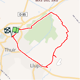
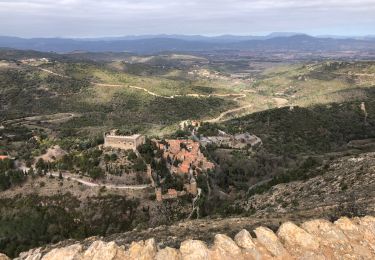
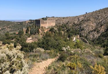
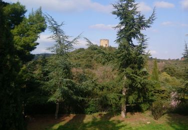
15 km | 18,2 km-effort
2h 36min
![](https://static1.geolcdn.com/siteimages/upload/files/16400158638029165_repeat_loop_refresh_sync_direction_icon.png)
Ja
![Tocht Stappen Castelnou - CASTELNOU 66 - CAMELAS - ermitage San Marti de La Roca - Photo](https://media.geolcdn.com/t/375/260/ext.jpg?maxdim=2&url=https%3A%2F%2Fservices.sitytrail.com%2FGeolivesWS%2FDownloadMedia.ashx%3FTrailID%3D429684%26Media%3D20150604190036.jpg)
![Stappen Stappen](https://static1.geolcdn.com/sitytour/trail-icons/101.png)
CASTELNOU 66 - CAMELAS - ermitage San Marti de La Roca
Stappen
Moeilijk
(1)
Castelnou,
Occitanië,
Pyrénées-Orientales,
France
![](/images/other/stat-length.png)
10,8 km | 16,7 km-effort
2h 19min
![](https://static1.geolcdn.com/siteimages/upload/files/16400158638029165_repeat_loop_refresh_sync_direction_icon.png)
Ja
![Tocht Stappen Thuir - Thuir à Castelnou - Photo](https://media.geolcdn.com/t/375/260/ext.jpg?maxdim=2&url=https%3A%2F%2Fservices.sitytrail.com%2FGeolivesWS%2FDownloadMedia.ashx%3FTrailID%3D258395%26Media%3Dfix__20140318123220.jpg)
![Stappen Stappen](https://static1.geolcdn.com/sitytour/trail-icons/101.png)
Thuir à Castelnou
Stappen
Medium
(1)
Thuir,
Occitanië,
Pyrénées-Orientales,
France
![](/images/other/stat-length.png)
14,1 km | 20 km-effort
4h 13min
![](https://static1.geolcdn.com/siteimages/upload/files/16400158638029165_repeat_loop_refresh_sync_direction_icon.png)
Ja
![Tocht Stappen Castelnou - Thuir - Photo](https://media.geolcdn.com/t/375/260/859f847a-b7fe-48a7-a491-a2880e534b4c.jpg&format=jpg&maxdim=2)
![Stappen Stappen](https://static1.geolcdn.com/sitytour/trail-icons/101.png)
Thuir
Stappen
Heel gemakkelijk
(1)
Castelnou,
Occitanië,
Pyrénées-Orientales,
France
![](/images/other/stat-length.png)
9,3 km | 12,1 km-effort
4h 4min
![](https://static1.geolcdn.com/siteimages/upload/files/16400158638029165_repeat_loop_refresh_sync_direction_icon.png)
Neen
![Tocht Stappen Castelnou - castel nous - Photo](https://media.geolcdn.com/t/375/260/735ce854-126b-4b61-b12b-e2ee30b4f64c.jpg&format=jpg&maxdim=2)
![Stappen Stappen](https://static1.geolcdn.com/sitytour/trail-icons/101.png)
castel nous
Stappen
Heel gemakkelijk
(1)
Castelnou,
Occitanië,
Pyrénées-Orientales,
France
![](/images/other/stat-length.png)
11,9 km | 16,7 km-effort
4h 0min
![](https://static1.geolcdn.com/siteimages/upload/files/16400158638029165_repeat_loop_refresh_sync_direction_icon.png)
Ja
![Tocht Stappen Sainte-Colombe-de-la-Commanderie - THUIR 66 - Castelnou - Ste Colombe de la C. - Photo](https://media.geolcdn.com/t/375/260/ext.jpg?maxdim=2&url=https%3A%2F%2Fstatic1.geolcdn.com%2Fsiteimages%2Fupload%2Ffiles%2F1553511878bg_sport_marche.png)
![Stappen Stappen](https://static1.geolcdn.com/sitytour/trail-icons/101.png)
THUIR 66 - Castelnou - Ste Colombe de la C.
Stappen
Medium
(2)
Sainte-Colombe-de-la-Commanderie,
Occitanië,
Pyrénées-Orientales,
France
![](/images/other/stat-length.png)
14,8 km | 21 km-effort
2h 56min
![](https://static1.geolcdn.com/siteimages/upload/files/16400158638029165_repeat_loop_refresh_sync_direction_icon.png)
Ja
![Tocht Stappen Sainte-Colombe-de-la-Commanderie - 20230316 Sté Colombe-Castelnou - Photo](https://media.geolcdn.com/t/375/260/6a656346-91c6-4259-b6c1-08c8da8c5ca9.jpg&format=jpg&maxdim=2)
![Stappen Stappen](https://static1.geolcdn.com/sitytour/trail-icons/101.png)
20230316 Sté Colombe-Castelnou
Stappen
Medium
Sainte-Colombe-de-la-Commanderie,
Occitanië,
Pyrénées-Orientales,
France
![](/images/other/stat-length.png)
16,3 km | 23 km-effort
3h 55min
![](https://static1.geolcdn.com/siteimages/upload/files/16400158638029165_repeat_loop_refresh_sync_direction_icon.png)
Ja
![Tocht Stappen Castelnou - 20210328 Castelnou-Camelas- boucl - Photo](https://media.geolcdn.com/t/375/260/e16529eb-fda5-4510-bd1d-e8469a334ea8.jpg&format=jpg&maxdim=2)
![Stappen Stappen](https://static1.geolcdn.com/sitytour/trail-icons/101.png)
20210328 Castelnou-Camelas- boucl
Stappen
Medium
Castelnou,
Occitanië,
Pyrénées-Orientales,
France
![](/images/other/stat-length.png)
15,4 km | 23 km-effort
4h 1min
![](https://static1.geolcdn.com/siteimages/upload/files/16400158638029165_repeat_loop_refresh_sync_direction_icon.png)
Ja
![Tocht Stappen Castelnou - Autour de Castelnou via St Marti de la Roca - Photo](https://media.geolcdn.com/t/375/260/daecf3a2-2fb8-4d19-b871-d41d1ec86642.jpg&format=jpg&maxdim=2)
![Stappen Stappen](https://static1.geolcdn.com/sitytour/trail-icons/101.png)
Autour de Castelnou via St Marti de la Roca
Stappen
Medium
Castelnou,
Occitanië,
Pyrénées-Orientales,
France
![](/images/other/stat-length.png)
13,5 km | 21 km-effort
3h 11min
![](https://static1.geolcdn.com/siteimages/upload/files/16400158638029165_repeat_loop_refresh_sync_direction_icon.png)
Ja