![](/images/other/stat-length.png)
![Tocht Mountainbike Louvemont - Espace VTT FFC Lac du Der en Champagne - Circuit n°06 - Le canal des Fabriques - Photo](https://media.geolcdn.com/t/1900/400/ext.pjpeg?maxdim=2&url=https%3A%2F%2Fservices.sitytrail.com%2FGeolivesWS%2FDownloadMedia.ashx%3FTrailID%3D102267%26Media%3D2728_1.jpg)
Espace VTT FFC Lac du Der en Champagne - Circuit n°06 - Le canal des Fabriques
tracegps
Gebruiker
![Lengte](/images/other/stat-length.png)
Lengte
8,8 km
![Max. hoogte](https://static1.geolcdn.com/siteimages/upload/files/1508320355ic_sort_altitude_max_24dp.png)
Max. hoogte
186 m
![Positief hoogteverschil](https://static1.geolcdn.com/siteimages/upload/files/1508320355ic_sort_den_pos_24dp.png)
Positief hoogteverschil
78 m
![Km-Effort](/images/other/stat-length.png)
Km-Effort
9,9 km
![Min. hoogte](https://static1.geolcdn.com/siteimages/upload/files/1508320355ic_sort_altitude_min_24dp.png)
Min. hoogte
139 m
![Negatief hoogteverschil](https://static1.geolcdn.com/siteimages/upload/files/1508320355ic_sort_den_neg_24dp.png)
Negatief hoogteverschil
79 m
![Boucle](https://static1.geolcdn.com/siteimages/upload/files/16400158638029165_repeat_loop_refresh_sync_direction_icon.png)
Boucle
Ja
Datum van aanmaak :
2014-12-10 00:00:00.0
Laatste wijziging :
2014-12-10 00:00:00.0
![Mountainbike](https://static1.geolcdn.com/sitytour/trail-icons/202.png)
40m
Moeilijkheid : Medium
![Scan deze QR-code om de tocht te openen in de SityTrail-applicatie](https://capi.geolives.com/qq0zvz2zws4bq2lad0pu/sitytour/trails/102267/qr.png?size=200)
Gratisgps-wandelapplicatie
Over ons
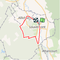
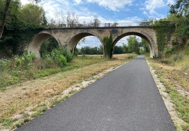
Tocht Mountainbike van 8,8 km beschikbaar op Grand Est, Haute-Marne, Louvemont. Deze tocht wordt voorgesteld door tracegps.
Beschrijving
Espace VTT - FFC Lac du Der en Champagne Circuit officiel labellisé par la Fédération Française de Cyclisme. Cette promenade vous offre un aperçu de l’aventure métallurgique de la Vallée de la Blaise.
Plaatsbepaling
Land:
France
Regio :
Grand Est
Departement/Provincie :
Haute-Marne
Gemeente :
Louvemont
Locatie:
Unknown
Vertrek:(Dec)
Vertrek:(UTM)
641165 ; 5379551 (31U) N.
Opmerkingen
Wandeltochten in de omgeving
![Tocht Mountainbike Louvemont - LAC du DER ... le canal des Fabriques. - Photo](https://media.geolcdn.com/t/375/260/b6538103-d610-48f2-ba11-16ea1b3e6267.jpg&format=jpg&maxdim=2)
![Mountainbike Mountainbike](https://static1.geolcdn.com/sitytour/trail-icons/202.png)
LAC du DER ... le canal des Fabriques.
Mountainbike
Heel gemakkelijk
Louvemont,
Grand Est,
Haute-Marne,
France
![](/images/other/stat-length.png)
9,7 km | 10,9 km-effort
1h 27min
![](https://static1.geolcdn.com/siteimages/upload/files/16400158638029165_repeat_loop_refresh_sync_direction_icon.png)
Ja
![Tocht Mountainbike Éclaron-Braucourt-Sainte-Livière - Lac du DER - CHANTECOQ ... par St-Marie- Nuisement. - Photo](https://media.geolcdn.com/t/375/260/0f27a926-3a1d-4ecb-8e04-b7fa88246190.jpg&format=jpg&maxdim=2)
![Mountainbike Mountainbike](https://static1.geolcdn.com/sitytour/trail-icons/202.png)
Lac du DER - CHANTECOQ ... par St-Marie- Nuisement.
Mountainbike
Heel gemakkelijk
Éclaron-Braucourt-Sainte-Livière,
Grand Est,
Haute-Marne,
France
![](/images/other/stat-length.png)
37 km | 40 km-effort
3h 13min
![](https://static1.geolcdn.com/siteimages/upload/files/16400158638029165_repeat_loop_refresh_sync_direction_icon.png)
Ja
![Tocht Wegfiets Louvemont - 24 08 2020 WASSY - Photo](https://media.geolcdn.com/t/375/260/792bb28f-ea85-4049-9dd3-646f5ebb5ba7.jpg&format=jpg&maxdim=2)
![Wegfiets Wegfiets](https://static1.geolcdn.com/sitytour/trail-icons/201.png)
24 08 2020 WASSY
Wegfiets
Gemakkelijk
Louvemont,
Grand Est,
Haute-Marne,
France
![](/images/other/stat-length.png)
37 km | 40 km-effort
2h 27min
![](https://static1.geolcdn.com/siteimages/upload/files/16400158638029165_repeat_loop_refresh_sync_direction_icon.png)
Neen
![Tocht Stappen Humbécourt - Humbécourt cimetière Nadine - Photo](https://media.geolcdn.com/t/375/260/ext.jpg?maxdim=2&url=https%3A%2F%2Fstatic1.geolcdn.com%2Fsiteimages%2Fupload%2Ffiles%2F1553511878bg_sport_marche.png)
![Stappen Stappen](https://static1.geolcdn.com/sitytour/trail-icons/101.png)
Humbécourt cimetière Nadine
Stappen
Humbécourt,
Grand Est,
Haute-Marne,
France
![](/images/other/stat-length.png)
8,3 km | 9,2 km-effort
2h 25min
![](https://static1.geolcdn.com/siteimages/upload/files/16400158638029165_repeat_loop_refresh_sync_direction_icon.png)
Ja
![Tocht Stappen Éclaron-Braucourt-Sainte-Livière - Sources du Lac Nadine OKOK - Photo](https://media.geolcdn.com/t/375/260/ext.jpg?maxdim=2&url=https%3A%2F%2Fstatic1.geolcdn.com%2Fsiteimages%2Fupload%2Ffiles%2F1553511878bg_sport_marche.png)
![Stappen Stappen](https://static1.geolcdn.com/sitytour/trail-icons/101.png)
Sources du Lac Nadine OKOK
Stappen
Éclaron-Braucourt-Sainte-Livière,
Grand Est,
Haute-Marne,
France
![](/images/other/stat-length.png)
8,3 km | 9,6 km-effort
2h 33min
![](https://static1.geolcdn.com/siteimages/upload/files/16400158638029165_repeat_loop_refresh_sync_direction_icon.png)
Ja
![Tocht Stappen Humbécourt - Humbécourt cimetière Nadine - Photo](https://media.geolcdn.com/t/375/260/ext.jpg?maxdim=2&url=https%3A%2F%2Fstatic1.geolcdn.com%2Fsiteimages%2Fupload%2Ffiles%2F1553511878bg_sport_marche.png)
![Stappen Stappen](https://static1.geolcdn.com/sitytour/trail-icons/101.png)
Humbécourt cimetière Nadine
Stappen
Humbécourt,
Grand Est,
Haute-Marne,
France
![](/images/other/stat-length.png)
8,6 km | 9,7 km-effort
2h 38min
![](https://static1.geolcdn.com/siteimages/upload/files/16400158638029165_repeat_loop_refresh_sync_direction_icon.png)
Ja
![Tocht Stappen Attancourt - ASLH/Attancourt/vers Wassy - Photo](https://media.geolcdn.com/t/375/260/ext.jpg?maxdim=2&url=https%3A%2F%2Fstatic1.geolcdn.com%2Fsiteimages%2Fupload%2Ffiles%2F1553511878bg_sport_marche.png)
![Stappen Stappen](https://static1.geolcdn.com/sitytour/trail-icons/101.png)
ASLH/Attancourt/vers Wassy
Stappen
Attancourt,
Grand Est,
Haute-Marne,
France
![](/images/other/stat-length.png)
10,2 km | 11 km-effort
3h 43min
![](https://static1.geolcdn.com/siteimages/upload/files/16400158638029165_repeat_loop_refresh_sync_direction_icon.png)
Ja
![Tocht Stappen Wassy - Pont Varin église - Photo](https://media.geolcdn.com/t/375/260/ext.jpg?maxdim=2&url=https%3A%2F%2Fstatic1.geolcdn.com%2Fsiteimages%2Fupload%2Ffiles%2F1553511878bg_sport_marche.png)
![Stappen Stappen](https://static1.geolcdn.com/sitytour/trail-icons/101.png)
Pont Varin église
Stappen
Wassy,
Grand Est,
Haute-Marne,
France
![](/images/other/stat-length.png)
9,8 km | 11,1 km-effort
2h 43min
![](https://static1.geolcdn.com/siteimages/upload/files/16400158638029165_repeat_loop_refresh_sync_direction_icon.png)
Neen
![Tocht Fiets Éclaron-Braucourt-Sainte-Livière - philibert Haute Marne1 - Photo](https://media.geolcdn.com/t/375/260/ext.jpg?maxdim=2&url=https%3A%2F%2Fstatic1.geolcdn.com%2Fsiteimages%2Fupload%2Ffiles%2F1524743154velo.jpg)
![Fiets Fiets](https://static1.geolcdn.com/sitytour/trail-icons/200.png)
philibert Haute Marne1
Fiets
Heel gemakkelijk
Éclaron-Braucourt-Sainte-Livière,
Grand Est,
Haute-Marne,
France
![](/images/other/stat-length.png)
41 km | 46 km-effort
7h 13min
![](https://static1.geolcdn.com/siteimages/upload/files/16400158638029165_repeat_loop_refresh_sync_direction_icon.png)
Ja