![](/images/other/stat-length.png)
![Tocht Mountainbike Saint-Anthème - Espace VTT FFC de la Vallée de l'Ance - Circuit n° 4 - Photo](https://media.geolcdn.com/t/1900/400/ext.pjpeg?maxdim=2&url=https%3A%2F%2Fservices.sitytrail.com%2FGeolivesWS%2FDownloadMedia.ashx%3FTrailID%3D101964%26Media%3D2259_1.jpg)
Espace VTT FFC de la Vallée de l'Ance - Circuit n° 4
tracegps
Gebruiker
![Lengte](/images/other/stat-length.png)
![Max. hoogte](https://static1.geolcdn.com/siteimages/upload/files/1508320355ic_sort_altitude_max_24dp.png)
![Positief hoogteverschil](https://static1.geolcdn.com/siteimages/upload/files/1508320355ic_sort_den_pos_24dp.png)
![Km-Effort](/images/other/stat-length.png)
![Min. hoogte](https://static1.geolcdn.com/siteimages/upload/files/1508320355ic_sort_altitude_min_24dp.png)
![Negatief hoogteverschil](https://static1.geolcdn.com/siteimages/upload/files/1508320355ic_sort_den_neg_24dp.png)
![Boucle](https://static1.geolcdn.com/siteimages/upload/files/16400158638029165_repeat_loop_refresh_sync_direction_icon.png)
![Mountainbike](https://static1.geolcdn.com/sitytour/trail-icons/202.png)
2h00
Moeilijkheid : Medium
![Scan deze QR-code om de tocht te openen in de SityTrail-applicatie](https://capi.geolives.com/qq0zvz2zws4bq2lad0pu/sitytour/trails/101964/qr.png?size=200)
Gratisgps-wandelapplicatie
Over ons
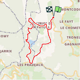
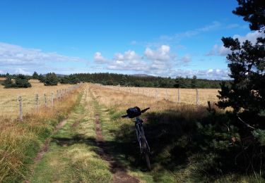
Tocht Mountainbike van 14,8 km beschikbaar op Auvergne-Rhône-Alpes, Puy-de-Dôme, Saint-Anthème. Deze tocht wordt voorgesteld door tracegps.
Beschrijving
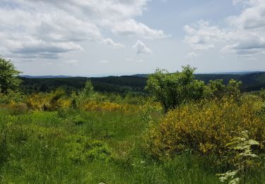
Espace VTT FFC de la Vallée de l’Ance Circuit labellisé par la Fédération Française de Cyclisme. Ce circuit assez facile dans son ensemble, vous fera découvrir le domaine des jasseries (La Fayolle, Grande Fayerie) et le barrage des Pradeaux. Il vous permettra d’admirer de magnifiques panoramas. Seule difficulté ; une montée technique sur un chemin très abîmé, peu après le col des Pradeaux.
Plaatsbepaling
Opmerkingen
Wandeltochten in de omgeving
![Tocht Stappen Valcivières - Les Jasseries des Supeyres - Valcivières - Photo](https://media.geolcdn.com/t/375/260/ext.jpg?maxdim=2&url=https%3A%2F%2Fservices.sitytrail.com%2FGeolivesWS%2FDownloadMedia.ashx%3FTrailID%3D173065%26Media%3D14595_6.jpg)
![Stappen Stappen](https://static1.geolcdn.com/sitytour/trail-icons/101.png)
Stappen
![](/images/other/stat-length.png)
![](https://static1.geolcdn.com/siteimages/upload/files/16400158638029165_repeat_loop_refresh_sync_direction_icon.png)
![Tocht Stappen Valcivières - Le colporteur des jasseries - Col des Supeyres -Valcivières - Photo](https://media.geolcdn.com/t/375/260/ext.jpg?maxdim=2&url=https%3A%2F%2Fservices.sitytrail.com%2FGeolivesWS%2FDownloadMedia.ashx%3FTrailID%3D107152%26Media%3D11995_3.jpg)
![Stappen Stappen](https://static1.geolcdn.com/sitytour/trail-icons/101.png)
Stappen
![](/images/other/stat-length.png)
![](https://static1.geolcdn.com/siteimages/upload/files/16400158638029165_repeat_loop_refresh_sync_direction_icon.png)
![Tocht Te voet Saint-Anthème - Le Colporteur des Jasseries - Photo](https://media.geolcdn.com/t/375/260/bb8cf573-2abe-46cd-9375-5ca50a964f5d.jpeg&format=jpg&maxdim=2)
![Te voet Te voet](https://static1.geolcdn.com/sitytour/trail-icons/100.png)
Te voet
![](/images/other/stat-length.png)
![](https://static1.geolcdn.com/siteimages/upload/files/16400158638029165_repeat_loop_refresh_sync_direction_icon.png)
![Tocht Te voet Valcivières - Les Hautes Chaumes - Photo](https://media.geolcdn.com/t/375/260/c021c51c-10d6-4fa3-97fc-c48a9b2a32e9.jpeg&format=jpg&maxdim=2)
![Te voet Te voet](https://static1.geolcdn.com/sitytour/trail-icons/100.png)
Te voet
![](/images/other/stat-length.png)
![](https://static1.geolcdn.com/siteimages/upload/files/16400158638029165_repeat_loop_refresh_sync_direction_icon.png)
![Tocht Te voet Saint-Anthème - Beauvoir - Photo](https://media.geolcdn.com/t/375/260/ae7f9019-dbcd-4e47-bc79-4b22438f3ce2.jpeg&format=jpg&maxdim=2)
![Te voet Te voet](https://static1.geolcdn.com/sitytour/trail-icons/100.png)
Te voet
![](/images/other/stat-length.png)
![](https://static1.geolcdn.com/siteimages/upload/files/16400158638029165_repeat_loop_refresh_sync_direction_icon.png)
![Tocht Stappen Saint-Anthème - Col des Supeyres au départ du Coq noir - Photo](https://media.geolcdn.com/t/375/260/a5f589cb-cae4-4a52-a71d-8c519e83f668.jpg&format=jpg&maxdim=2)
![Stappen Stappen](https://static1.geolcdn.com/sitytour/trail-icons/101.png)
Stappen
![](/images/other/stat-length.png)
![](https://static1.geolcdn.com/siteimages/upload/files/16400158638029165_repeat_loop_refresh_sync_direction_icon.png)
![Tocht Te voet Saint-Anthème - Les Prats-de-la-Chaux - Photo](https://media.geolcdn.com/t/375/260/ae7f9019-dbcd-4e47-bc79-4b22438f3ce2.jpeg&format=jpg&maxdim=2)
![Te voet Te voet](https://static1.geolcdn.com/sitytour/trail-icons/100.png)
Te voet
![](/images/other/stat-length.png)
![](https://static1.geolcdn.com/siteimages/upload/files/16400158638029165_repeat_loop_refresh_sync_direction_icon.png)
![Tocht Mountainbike Saint-Anthème - Descente barracuchet Montbrison - Photo](https://media.geolcdn.com/t/375/260/2544011a-6e3c-42be-8ca9-7444665c9346.jpg&format=jpg&maxdim=2)
![Mountainbike Mountainbike](https://static1.geolcdn.com/sitytour/trail-icons/202.png)
Mountainbike
![](/images/other/stat-length.png)
![](https://static1.geolcdn.com/siteimages/upload/files/16400158638029165_repeat_loop_refresh_sync_direction_icon.png)
![Tocht Stappen Saint-Anthème - boucle des Pradeaux - Photo](https://media.geolcdn.com/t/375/260/ext.jpg?maxdim=2&url=https%3A%2F%2Fservices.sitytrail.com%2FGeolivesWS%2FDownloadMedia.ashx%3FTrailID%3D983955%26Media%3Dfix__20180610133330.jpg)
![Stappen Stappen](https://static1.geolcdn.com/sitytour/trail-icons/101.png)
Stappen
![](/images/other/stat-length.png)
![](https://static1.geolcdn.com/siteimages/upload/files/16400158638029165_repeat_loop_refresh_sync_direction_icon.png)