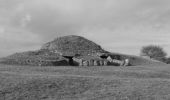

Tumulus de Dissignac

tracegps
Gebruiker

Lengte
12,5 km

Max. hoogte
46 m

Positief hoogteverschil
75 m

Km-Effort
13,5 km

Min. hoogte
22 m

Negatief hoogteverschil
75 m
Boucle
Ja
Datum van aanmaak :
2014-12-10 00:00:00.0
Laatste wijziging :
2014-12-10 00:00:00.0
45m
Moeilijkheid : Gemakkelijk

Gratisgps-wandelapplicatie
Over ons
Tocht Mountainbike van 12,5 km beschikbaar op Pays de la Loire, Loire-Atlantique, Saint-Nazaire. Deze tocht wordt voorgesteld door tracegps.
Beschrijving
Départ / Arrivée sur le parking du Tumulus. Suivant la période de l'année visite guidée possible. Le circuite passe également près d'un Cromlech. Terrain très facile : toutes petites routes, chemins aménagés. A faire en famille.
Plaatsbepaling
Land:
France
Regio :
Pays de la Loire
Departement/Provincie :
Loire-Atlantique
Gemeente :
Saint-Nazaire
Locatie:
Unknown
Vertrek:(Dec)
Vertrek:(UTM)
554615 ; 5235540 (30T) N.
Opmerkingen
Wandeltochten in de omgeving

promenade sur la plage


Stappen
Heel gemakkelijk
(1)
Pornichet,
Pays de la Loire,
Loire-Atlantique,
France

4,1 km | 4,4 km-effort
48min
Ja

Étang du Bois Joalland


Stappen
Gemakkelijk
Saint-Nazaire,
Pays de la Loire,
Loire-Atlantique,
France

3,5 km | 3,8 km-effort
1h 14min
Neen
La Loire à Vélo de St Nazaire à Cosne sur Loire


Fiets
Medium
(1)
Saint-Nazaire,
Pays de la Loire,
Loire-Atlantique,
France

560 km | 611 km-effort
40h 0min
Neen
Bellefontaine-Porcé


Stappen
Gemakkelijk
Saint-Nazaire,
Pays de la Loire,
Loire-Atlantique,
France

4,7 km | 5,5 km-effort
1h 0min
Ja
Bellefontaine-Porcé


Stappen
Gemakkelijk
Saint-Nazaire,
Pays de la Loire,
Loire-Atlantique,
France

4,7 km | 5,5 km-effort
1h 0min
Ja
Circuit du Point du Jour - Saint Nazaire


Mountainbike
Moeilijk
Saint-Nazaire,
Pays de la Loire,
Loire-Atlantique,
France

24 km | 26 km-effort
2h 30min
Ja
St-Nazaire à Pornichet(27K 380D+)


Trail
Medium
Saint-Nazaire,
Pays de la Loire,
Loire-Atlantique,
France

27 km | 32 km-effort
4h 3min
Neen
pornichet, ste Marguerite, hippodrome, port


Noords wandelen
Heel gemakkelijk
Pornichet,
Pays de la Loire,
Loire-Atlantique,
France

8,4 km | 9,3 km-effort
1h 15min
Ja
la Roche Bernard : les rosquets


Stappen
Gemakkelijk
Pornichet,
Pays de la Loire,
Loire-Atlantique,
France

32 km | 37 km-effort
5h 48min
Neen


 SityTrail


