![](/images/other/stat-length.png)
![Tocht Mountainbike Riotord - Espace VTT FFC Le Velay des 3 Rivières - N°38 Clavas - Riotord - Photo](https://media.geolcdn.com/t/1900/400/ext.pjpeg?maxdim=2&url=https%3A%2F%2Fservices.sitytrail.com%2FGeolivesWS%2FDownloadMedia.ashx%3FTrailID%3D101869%26Media%3D2157_1.jpg)
Espace VTT FFC Le Velay des 3 Rivières - N°38 Clavas - Riotord
tracegps
Gebruiker
![Lengte](/images/other/stat-length.png)
![Max. hoogte](https://static1.geolcdn.com/siteimages/upload/files/1508320355ic_sort_altitude_max_24dp.png)
![Positief hoogteverschil](https://static1.geolcdn.com/siteimages/upload/files/1508320355ic_sort_den_pos_24dp.png)
![Km-Effort](/images/other/stat-length.png)
![Min. hoogte](https://static1.geolcdn.com/siteimages/upload/files/1508320355ic_sort_altitude_min_24dp.png)
![Negatief hoogteverschil](https://static1.geolcdn.com/siteimages/upload/files/1508320355ic_sort_den_neg_24dp.png)
![Boucle](https://static1.geolcdn.com/siteimages/upload/files/16400158638029165_repeat_loop_refresh_sync_direction_icon.png)
![Mountainbike](https://static1.geolcdn.com/sitytour/trail-icons/202.png)
3h30
Moeilijkheid : Zeer moeilijk
![Scan deze QR-code om de tocht te openen in de SityTrail-applicatie](https://capi.geolives.com/qq0zvz2zws4bq2lad0pu/sitytour/trails/101869/qr.png?size=200)
Gratisgps-wandelapplicatie
Over ons
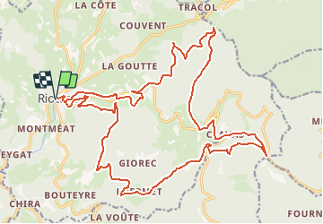
Tocht Mountainbike van 29 km beschikbaar op Auvergne-Rhône-Alpes, Haute-Loire, Riotord. Deze tocht wordt voorgesteld door tracegps.
Beschrijving
Espace VTT FFC Le Velay des 3 Rivières Circuit labellisé par la Fédération Française de Cyclisme. En grande partie en sous bois, ce parcours très physique sillonne les chemins des anciennes terres de l'abbaye de Clavas. Le topo-guide Chamina est en vente dans le réseau Chamina, dans les Offices de Tourisme du territoire et auprès du Syndicat d’Initiative.
Plaatsbepaling
Opmerkingen
Wandeltochten in de omgeving
![Tocht Wegfiets Riotord - 42 st genest malifaux passerelle lijgnon yssingeaux - Photo](https://media.geolcdn.com/t/375/260/e0041052-8929-4565-8568-929e31afc12b.jpg&format=jpg&maxdim=2)
![Wegfiets Wegfiets](https://static1.geolcdn.com/sitytour/trail-icons/201.png)
Wegfiets
![](/images/other/stat-length.png)
![](https://static1.geolcdn.com/siteimages/upload/files/16400158638029165_repeat_loop_refresh_sync_direction_icon.png)
![Tocht Mountainbike Riotord - Ru de Saint Meyras - Riotord - Photo](https://media.geolcdn.com/t/375/260/ext.jpg?maxdim=2&url=https%3A%2F%2Fservices.sitytrail.com%2FGeolivesWS%2FDownloadMedia.ashx%3FTrailID%3D172749%26Media%3D14153_6.jpg)
![Mountainbike Mountainbike](https://static1.geolcdn.com/sitytour/trail-icons/202.png)
Mountainbike
![](/images/other/stat-length.png)
![](https://static1.geolcdn.com/siteimages/upload/files/16400158638029165_repeat_loop_refresh_sync_direction_icon.png)
![Tocht Stappen Riotord - Ru de Saint Meyras - Riotord - Photo](https://media.geolcdn.com/t/375/260/ext.jpg?maxdim=2&url=https%3A%2F%2Fservices.sitytrail.com%2FGeolivesWS%2FDownloadMedia.ashx%3FTrailID%3D172748%26Media%3D14153_6.jpg)
![Stappen Stappen](https://static1.geolcdn.com/sitytour/trail-icons/101.png)
Stappen
![](/images/other/stat-length.png)
![](https://static1.geolcdn.com/siteimages/upload/files/16400158638029165_repeat_loop_refresh_sync_direction_icon.png)
![Tocht Stappen Dunières - Marlgles - Photo](https://media.geolcdn.com/t/375/260/53d9ca73-322e-40ba-a3bb-95ddc0b750a8.jpg&format=jpg&maxdim=2)
![Stappen Stappen](https://static1.geolcdn.com/sitytour/trail-icons/101.png)
Stappen
![](/images/other/stat-length.png)
![](https://static1.geolcdn.com/siteimages/upload/files/16400158638029165_repeat_loop_refresh_sync_direction_icon.png)
![Tocht Mountainbike Dunières - voie verte Duniere Tracol - Photo](https://media.geolcdn.com/t/375/260/b6cbb374-58cf-46c7-b98e-163e098670c6.jpg&format=jpg&maxdim=2)
![Mountainbike Mountainbike](https://static1.geolcdn.com/sitytour/trail-icons/202.png)
Mountainbike
![](/images/other/stat-length.png)
![](https://static1.geolcdn.com/siteimages/upload/files/16400158638029165_repeat_loop_refresh_sync_direction_icon.png)
![Tocht Paardrijden Saint-Romain-Lachalm - Rando Saint-Romain-Lachalm / Riotord - Photo](https://media.geolcdn.com/t/375/260/61cda18a-e78f-4319-b8f1-24c19e241a25.jpg&format=jpg&maxdim=2)
![Paardrijden Paardrijden](https://static1.geolcdn.com/sitytour/trail-icons/301.png)
Paardrijden
![](/images/other/stat-length.png)
![](https://static1.geolcdn.com/siteimages/upload/files/16400158638029165_repeat_loop_refresh_sync_direction_icon.png)
![Tocht Mountainbike Dunières - Espace VTT FFC Le Velay des 3 Rivières - N°20 Le Bois de Chanteroux - Dunières - Photo](https://media.geolcdn.com/t/375/260/ext.jpg?maxdim=2&url=https%3A%2F%2Fservices.sitytrail.com%2FGeolivesWS%2FDownloadMedia.ashx%3FTrailID%3D101821%26Media%3D2096_1.jpg)
![Mountainbike Mountainbike](https://static1.geolcdn.com/sitytour/trail-icons/202.png)
Mountainbike
![](/images/other/stat-length.png)
![](https://static1.geolcdn.com/siteimages/upload/files/16400158638029165_repeat_loop_refresh_sync_direction_icon.png)
![Tocht Mountainbike Riotord - Espace VTT FFC Le Velay des 3 Rivières - N°11 Ravarines Riotord - Photo](https://media.geolcdn.com/t/375/260/ext.jpg?maxdim=2&url=https%3A%2F%2Fservices.sitytrail.com%2FGeolivesWS%2FDownloadMedia.ashx%3FTrailID%3D101774%26Media%3D2047_1.jpg)
![Mountainbike Mountainbike](https://static1.geolcdn.com/sitytour/trail-icons/202.png)
Mountainbike
![](/images/other/stat-length.png)
![](https://static1.geolcdn.com/siteimages/upload/files/16400158638029165_repeat_loop_refresh_sync_direction_icon.png)
![Tocht Mountainbike Dunières - Espace VTT FFC Le Velay des 3 Rivières - N°6 Le Fouvet Dunières - Photo](https://media.geolcdn.com/t/375/260/ext.jpg?maxdim=2&url=https%3A%2F%2Fservices.sitytrail.com%2FGeolivesWS%2FDownloadMedia.ashx%3FTrailID%3D101769%26Media%3D2042_1.jpg)
![Mountainbike Mountainbike](https://static1.geolcdn.com/sitytour/trail-icons/202.png)
Mountainbike
![](/images/other/stat-length.png)
![](https://static1.geolcdn.com/siteimages/upload/files/16400158638029165_repeat_loop_refresh_sync_direction_icon.png)