![](/images/other/stat-length.png)
![Tocht Stappen Jalhay - Solwaster - La Statte - Photo](https://media.geolcdn.com/t/1900/400/ext.pjpeg?maxdim=2&url=https%3A%2F%2Fstatic1.geolcdn.com%2Fsiteimages%2Fupload%2Ffiles%2F1553511878bg_sport_marche.png)
Solwaster - La Statte
mdecruy
Gebruiker
![Lengte](/images/other/stat-length.png)
Lengte
6 km
![Max. hoogte](https://static1.geolcdn.com/siteimages/upload/files/1508320355ic_sort_altitude_max_24dp.png)
Max. hoogte
482 m
![Positief hoogteverschil](https://static1.geolcdn.com/siteimages/upload/files/1508320355ic_sort_den_pos_24dp.png)
Positief hoogteverschil
131 m
![Km-Effort](/images/other/stat-length.png)
Km-Effort
7,7 km
![Min. hoogte](https://static1.geolcdn.com/siteimages/upload/files/1508320355ic_sort_altitude_min_24dp.png)
Min. hoogte
363 m
![Negatief hoogteverschil](https://static1.geolcdn.com/siteimages/upload/files/1508320355ic_sort_den_neg_24dp.png)
Negatief hoogteverschil
126 m
![Boucle](https://static1.geolcdn.com/siteimages/upload/files/16400158638029165_repeat_loop_refresh_sync_direction_icon.png)
Boucle
Ja
Datum van aanmaak :
2019-01-15 14:05:48.695
Laatste wijziging :
2019-01-15 14:05:48.695
![Stappen](https://static1.geolcdn.com/sitytour/trail-icons/101.png)
1h39
Moeilijkheid : Gemakkelijk
![Scan deze QR-code om de tocht te openen in de SityTrail-applicatie](https://capi.geolives.com/qq0zvz2zws4bq2lad0pu/sitytour/trails/1016233/qr.png?size=200)
Gratisgps-wandelapplicatie
Over ons
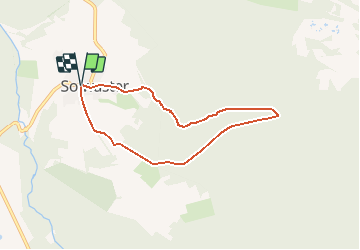
Tocht Stappen van 6 km beschikbaar op Wallonië, Luik, Jalhay. Deze tocht wordt voorgesteld door mdecruy.
Beschrijving
Sol humide, pierres glissantes, racines promptes à accrocher le pied : regardez vos pieds ! Et puis arrêtez-vous pour regarder la nature environnante : c'est très beau !
Plaatsbepaling
Land:
Belgium
Regio :
Wallonië
Departement/Provincie :
Luik
Gemeente :
Jalhay
Locatie:
Sart
Vertrek:(Dec)
Vertrek:(UTM)
710173 ; 5601101 (31U) N.
Opmerkingen
Wandeltochten in de omgeving
![Tocht Stappen Jalhay - RB-LG-06 Raccourci 2 - Photo](https://media.geolcdn.com/t/375/260/ext.jpg?maxdim=2&url=https%3A%2F%2Fservices.sitytrail.com%2FGeolivesWS%2FDownloadMedia.ashx%3FTrailID%3D209412%26Media%3Dcbaa668b-becb-4b36-acb0-64f56a1c97b3.jpg)
![Stappen Stappen](https://static1.geolcdn.com/sitytour/trail-icons/101.png)
RB-LG-06 Raccourci 2
Stappen
Moeilijk
(6)
Jalhay,
Wallonië,
Luik,
Belgium
![](/images/other/stat-length.png)
10,1 km | 13,3 km-effort
3h 1min
![](https://static1.geolcdn.com/siteimages/upload/files/16400158638029165_repeat_loop_refresh_sync_direction_icon.png)
Ja
![Tocht Stappen Jalhay - RB-LG-06 - Au pied du plateau des Hautes Fagnes La balade des ruisseaux - Photo](https://media.geolcdn.com/t/375/260/ext.jpg?maxdim=2&url=https%3A%2F%2Fservices.sitytrail.com%2FGeolivesWS%2FDownloadMedia.ashx%3FTrailID%3D179564%26Media%3Dcbaa668b-becb-4b36-acb0-64f56a1c97b3.jpg)
![Stappen Stappen](https://static1.geolcdn.com/sitytour/trail-icons/101.png)
RB-LG-06 - Au pied du plateau des Hautes Fagnes La balade des ruisseaux
Stappen
Zeer moeilijk
(7)
Jalhay,
Wallonië,
Luik,
Belgium
![](/images/other/stat-length.png)
26 km | 35 km-effort
8h 0min
![](https://static1.geolcdn.com/siteimages/upload/files/16400158638029165_repeat_loop_refresh_sync_direction_icon.png)
Ja
![Tocht Stappen Jalhay - Solwaster. Natura 2000, des sites qui valent le détour. Lg8 - Photo](https://media.geolcdn.com/t/375/260/ext.jpg?maxdim=2&url=https%3A%2F%2Fservices.sitytrail.com%2FGeolivesWS%2FDownloadMedia.ashx%3FTrailID%3D185776%26Media%3D07ec0791-d24b-4377-8f42-10c75b77cede.jpg)
![Stappen Stappen](https://static1.geolcdn.com/sitytour/trail-icons/101.png)
Solwaster. Natura 2000, des sites qui valent le détour. Lg8
Stappen
Moeilijk
(9)
Jalhay,
Wallonië,
Luik,
Belgium
![](/images/other/stat-length.png)
6,8 km | 9,1 km-effort
1h 58min
![](https://static1.geolcdn.com/siteimages/upload/files/16400158638029165_repeat_loop_refresh_sync_direction_icon.png)
Ja
![Tocht Stappen Jalhay - Pont de Belleheid à Spa par le GRP 573 - Photo](https://media.geolcdn.com/t/375/260/0d2f83e8-ec88-4180-940e-6c42b7bb9bcf.jpg&format=jpg&maxdim=2)
![Stappen Stappen](https://static1.geolcdn.com/sitytour/trail-icons/101.png)
Pont de Belleheid à Spa par le GRP 573
Stappen
Medium
(1)
Jalhay,
Wallonië,
Luik,
Belgium
![](/images/other/stat-length.png)
14 km | 17,8 km-effort
4h 2min
![](https://static1.geolcdn.com/siteimages/upload/files/16400158638029165_repeat_loop_refresh_sync_direction_icon.png)
Neen
![Stappen Stappen](https://static1.geolcdn.com/sitytour/trail-icons/101.png)
20220901 - Jehanster 5.3 Km
Stappen
Medium
(1)
Theux,
Wallonië,
Luik,
Belgium
![](/images/other/stat-length.png)
5,3 km | 6,8 km-effort
1h 32min
![](https://static1.geolcdn.com/siteimages/upload/files/16400158638029165_repeat_loop_refresh_sync_direction_icon.png)
Ja
![Stappen Stappen](https://static1.geolcdn.com/sitytour/trail-icons/101.png)
20211213 - Hockay 5.4 Km
Stappen
Medium
(3)
Stavelot,
Wallonië,
Luik,
Belgium
![](/images/other/stat-length.png)
5,1 km | 6,6 km-effort
1h 34min
![](https://static1.geolcdn.com/siteimages/upload/files/16400158638029165_repeat_loop_refresh_sync_direction_icon.png)
Ja
![Tocht Stappen Jalhay - 2021-11-16_21h27m43_Cirkwi-Balade_à_Jalhay-Royompré_-_47 - Photo](https://media.geolcdn.com/t/375/260/94c262e0-20e7-4ae2-8b45-01b4c31da73b.jpg&format=jpg&maxdim=2)
![Stappen Stappen](https://static1.geolcdn.com/sitytour/trail-icons/101.png)
2021-11-16_21h27m43_Cirkwi-Balade_à_Jalhay-Royompré_-_47
Stappen
Gemakkelijk
(2)
Jalhay,
Wallonië,
Luik,
Belgium
![](/images/other/stat-length.png)
11 km | 13,9 km-effort
3h 9min
![](https://static1.geolcdn.com/siteimages/upload/files/16400158638029165_repeat_loop_refresh_sync_direction_icon.png)
Ja
![Tocht Stappen Jalhay - 2021-11-16_21h12m11_Cirkwi-Solwaster_Sawe_-_balade_56_B (1) - Photo](https://media.geolcdn.com/t/375/260/081cadfc-4766-4923-92bf-f568c48bec7d.jpg&format=jpg&maxdim=2)
![Stappen Stappen](https://static1.geolcdn.com/sitytour/trail-icons/101.png)
2021-11-16_21h12m11_Cirkwi-Solwaster_Sawe_-_balade_56_B (1)
Stappen
Medium
(3)
Jalhay,
Wallonië,
Luik,
Belgium
![](/images/other/stat-length.png)
8,5 km | 11,4 km-effort
2h 36min
![](https://static1.geolcdn.com/siteimages/upload/files/16400158638029165_repeat_loop_refresh_sync_direction_icon.png)
Ja
![Tocht Lopen Jalhay - Jalhay-Trail-26km - Photo](https://media.geolcdn.com/t/375/260/cfb58ec0-2055-46b2-8eac-aa502bd39e7d.jpg&format=jpg&maxdim=2)
![Lopen Lopen](https://static1.geolcdn.com/sitytour/trail-icons/103.png)
Jalhay-Trail-26km
Lopen
Moeilijk
(9)
Jalhay,
Wallonië,
Luik,
Belgium
![](/images/other/stat-length.png)
26 km | 34 km-effort
3h 0min
![](https://static1.geolcdn.com/siteimages/upload/files/16400158638029165_repeat_loop_refresh_sync_direction_icon.png)
Ja