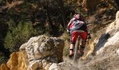

Espace VTT FFC Haute Bigorre - Circuit n° 7 - Col du Lhéris

tracegps
Gebruiker

Lengte
24 km

Max. hoogte
1343 m

Positief hoogteverschil
885 m

Km-Effort
36 km

Min. hoogte
545 m

Negatief hoogteverschil
891 m
Boucle
Ja
Datum van aanmaak :
2014-12-10 00:00:00.0
Laatste wijziging :
2014-12-10 00:00:00.0
3h30
Moeilijkheid : Zeer moeilijk

Gratisgps-wandelapplicatie
Over ons
Tocht Mountainbike van 24 km beschikbaar op Occitanië, Hautes-Pyrénées, Bagnères-de-Bigorre. Deze tocht wordt voorgesteld door tracegps.
Beschrijving
Haute Bigorre Circuit labellisé par la Fédération Française de Cyclisme. Cabane du berger du Lhéris, au pied su sommet du Casque du Lhéris (1595m), superbe vue sur les surplombs calcaires. Téléchargez le descriptif et le plan.
Plaatsbepaling
Land:
France
Regio :
Occitanië
Departement/Provincie :
Hautes-Pyrénées
Gemeente :
Bagnères-de-Bigorre
Locatie:
Unknown
Vertrek:(Dec)
Vertrek:(UTM)
268722 ; 4773072 (31T) N.
Opmerkingen
Wandeltochten in de omgeving

FEU 2015 - Etape 5


Stappen
Gemakkelijk
(1)
Bagnères-de-Bigorre,
Occitanië,
Hautes-Pyrénées,
France

18,2 km | 30 km-effort
6h 29min
Neen

FEU 2015 - Etape 4


Stappen
Gemakkelijk
(2)
Castillon,
Occitanië,
Hautes-Pyrénées,
France

11,6 km | 18,1 km-effort
3h 43min
Neen
Gerde


Stappen
Gemakkelijk
Bagnères-de-Bigorre,
Occitanië,
Hautes-Pyrénées,
France

9,7 km | 12,2 km-effort
2h 49min
Ja
Camp César Pouzac


Stappen
Medium
Pouzac,
Occitanië,
Hautes-Pyrénées,
France

6,6 km | 9,8 km-effort
1h 46min
Ja
Casque du Lheris


Stappen
Medium
Gerde,
Occitanië,
Hautes-Pyrénées,
France

16,8 km | 28 km-effort
6h 25min
Ja
Randonnée 1 mai haut de Bagneres


Mountainbike
Zeer moeilijk
Bagnères-de-Bigorre,
Occitanië,
Hautes-Pyrénées,
France

28 km | 38 km-effort
3h 18min
Ja
tour du castelmouly


Stappen
Gemakkelijk
(2)
Bagnères-de-Bigorre,
Occitanië,
Hautes-Pyrénées,
France

12,7 km | 20 km-effort
4h 3min
Ja
Casque du Lhéris - Gerde


Stappen
Medium
Gerde,
Occitanië,
Hautes-Pyrénées,
France

14,1 km | 24 km-effort
5h 0min
Ja
Bagnères de Bigorre bis VTT


Mountainbike
Moeilijk
Asté,
Occitanië,
Hautes-Pyrénées,
France

23 km | 36 km-effort
2h 30min
Ja


 SityTrail


