![](/images/other/stat-length.png)
![Tocht Stappen Formiguères - La Porteil.d Orlu au départ de Formiguères - Photo](https://media.geolcdn.com/t/1900/400/ext.pjpeg?maxdim=2&url=https%3A%2F%2Fservices.sitytrail.com%2FGeolivesWS%2FDownloadMedia.ashx%3FTrailID%3D1015795%26Media%3Dfix__20180802113925.jpg)
La Porteil.d Orlu au départ de Formiguères
MarieFrancoise
Gebruiker
![Lengte](/images/other/stat-length.png)
Lengte
17,9 km
![Max. hoogte](https://static1.geolcdn.com/siteimages/upload/files/1508320355ic_sort_altitude_max_24dp.png)
Max. hoogte
2294 m
![Positief hoogteverschil](https://static1.geolcdn.com/siteimages/upload/files/1508320355ic_sort_den_pos_24dp.png)
Positief hoogteverschil
872 m
![Km-Effort](/images/other/stat-length.png)
Km-Effort
30 km
![Min. hoogte](https://static1.geolcdn.com/siteimages/upload/files/1508320355ic_sort_altitude_min_24dp.png)
Min. hoogte
1600 m
![Negatief hoogteverschil](https://static1.geolcdn.com/siteimages/upload/files/1508320355ic_sort_den_neg_24dp.png)
Negatief hoogteverschil
882 m
![Boucle](https://static1.geolcdn.com/siteimages/upload/files/16400158638029165_repeat_loop_refresh_sync_direction_icon.png)
Boucle
Ja
Datum van aanmaak :
2019-05-27 16:39:49.55
Laatste wijziging :
2019-05-27 16:39:50.058
![Stappen](https://static1.geolcdn.com/sitytour/trail-icons/101.png)
6h36
Moeilijkheid : Medium
![Scan deze QR-code om de tocht te openen in de SityTrail-applicatie](https://capi.geolives.com/qq0zvz2zws4bq2lad0pu/sitytour/trails/1015795/qr.png?size=200)
Gratisgps-wandelapplicatie
Over ons
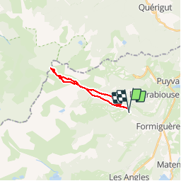
Tocht Stappen van 17,9 km beschikbaar op Occitanië, Pyrénées-Orientales, Formiguères. Deze tocht wordt voorgesteld door MarieFrancoise.
Beschrijving
Départ de la Station de Formiguères .
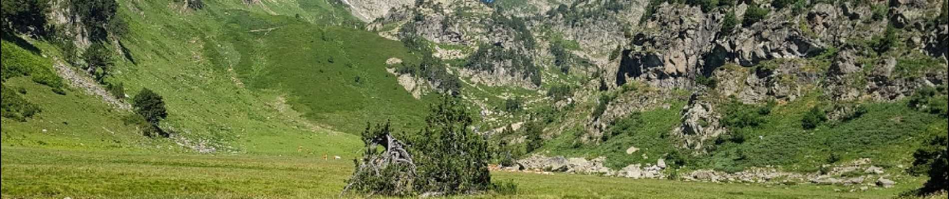
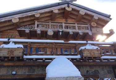
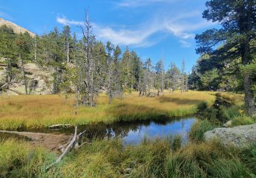
Plaatsbepaling
Land:
France
Regio :
Occitanië
Departement/Provincie :
Pyrénées-Orientales
Gemeente :
Formiguères
Locatie:
Unknown
Vertrek:(Dec)
Vertrek:(UTM)
423904 ; 4719602 (31T) N.
Opmerkingen
Wandeltochten in de omgeving
![Tocht Stappen Formiguères - Les Camporells par la Lladure - Photo](https://media.geolcdn.com/t/375/260/ext.jpg?maxdim=2&url=https%3A%2F%2Fstatic1.geolcdn.com%2Fsiteimages%2Fupload%2Ffiles%2F1553511878bg_sport_marche.png)
![Stappen Stappen](https://static1.geolcdn.com/sitytour/trail-icons/101.png)
Les Camporells par la Lladure
Stappen
Medium
(1)
Formiguères,
Occitanië,
Pyrénées-Orientales,
France
![](/images/other/stat-length.png)
15,1 km | 24 km-effort
5h 7min
![](https://static1.geolcdn.com/siteimages/upload/files/16400158638029165_repeat_loop_refresh_sync_direction_icon.png)
Ja
![Tocht sport Formiguères - 20240728 Station Formiguères - Camporeils - Photo](https://media.geolcdn.com/t/375/260/ext.jpg?maxdim=2&url=https%3A%2F%2Fmedia.geolcdn.com%2Ff%2Ff876415d-ce02-429d-b141-5520f07207a5.jpg)
20240728 Station Formiguères - Camporeils
sport
Heel gemakkelijk
Formiguères,
Occitanië,
Pyrénées-Orientales,
France
![](/images/other/stat-length.png)
16 km | 27 km-effort
Onbekend
![](https://static1.geolcdn.com/siteimages/upload/files/16400158638029165_repeat_loop_refresh_sync_direction_icon.png)
Ja
![Tocht Stappen Puyvalador - Puyvalador tour du lac - Photo](https://media.geolcdn.com/t/375/260/ext.jpg?maxdim=2&url=https%3A%2F%2Fmedia.geolcdn.com%2Ff%2F8f1726ec-7b11-4960-9385-ddf77a7154ab.jpg)
![Stappen Stappen](https://static1.geolcdn.com/sitytour/trail-icons/101.png)
Puyvalador tour du lac
Stappen
Heel gemakkelijk
Puyvalador,
Occitanië,
Pyrénées-Orientales,
France
![](/images/other/stat-length.png)
12,1 km | 15,9 km-effort
3h 39min
![](https://static1.geolcdn.com/siteimages/upload/files/16400158638029165_repeat_loop_refresh_sync_direction_icon.png)
Ja
![Tocht Stappen Formiguères - 20210819 Porteille d’Orlu, étang du diable - Photo](https://media.geolcdn.com/t/375/260/ext.jpg?maxdim=2&url=https%3A%2F%2Fmedia.geolcdn.com%2Ff%2Fdda65196-4e65-40c0-ab96-37c7b8dfe61a.jpg)
![Stappen Stappen](https://static1.geolcdn.com/sitytour/trail-icons/101.png)
20210819 Porteille d’Orlu, étang du diable
Stappen
Moeilijk
Formiguères,
Occitanië,
Pyrénées-Orientales,
France
![](/images/other/stat-length.png)
16,4 km | 29 km-effort
5h 3min
![](https://static1.geolcdn.com/siteimages/upload/files/16400158638029165_repeat_loop_refresh_sync_direction_icon.png)
Ja
![Tocht Stappen Formiguères - 20210710 pla del bosc - Foumigueres - Photo](https://media.geolcdn.com/t/375/260/ext.jpg?maxdim=2&url=https%3A%2F%2Fmedia.geolcdn.com%2Ff%2F1179261a-6605-4660-a8d9-78a9473ad380.jpg)
![Stappen Stappen](https://static1.geolcdn.com/sitytour/trail-icons/101.png)
20210710 pla del bosc - Foumigueres
Stappen
Gemakkelijk
Formiguères,
Occitanië,
Pyrénées-Orientales,
France
![](/images/other/stat-length.png)
12,5 km | 18,3 km-effort
2h 47min
![](https://static1.geolcdn.com/siteimages/upload/files/16400158638029165_repeat_loop_refresh_sync_direction_icon.png)
Ja
![Tocht Sneeuwschoenen Les Angles - 2021-02-11 Sortie CAF - Les Angles - vers les Camporells - Photo](https://media.geolcdn.com/t/375/260/ext.jpg?maxdim=2&url=https%3A%2F%2Fmedia.geolcdn.com%2Ff%2F397ddafb-ba3f-41cb-9f7e-51811b5e826b.JPG)
![Sneeuwschoenen Sneeuwschoenen](https://static1.geolcdn.com/sitytour/trail-icons/504.png)
2021-02-11 Sortie CAF - Les Angles - vers les Camporells
Sneeuwschoenen
Medium
Les Angles,
Occitanië,
Pyrénées-Orientales,
France
![](/images/other/stat-length.png)
16,8 km | 24 km-effort
7h 0min
![](https://static1.geolcdn.com/siteimages/upload/files/16400158638029165_repeat_loop_refresh_sync_direction_icon.png)
Ja
![Tocht Sneeuwschoenen Formiguères - Formigueres el collet - Photo](https://media.geolcdn.com/t/375/260/ext.jpg?maxdim=2&url=https%3A%2F%2Fmedia.geolcdn.com%2Ff%2Ffd8d553e-fbbc-4eac-9bcd-8fe4718e94f2.jpg)
![Sneeuwschoenen Sneeuwschoenen](https://static1.geolcdn.com/sitytour/trail-icons/504.png)
Formigueres el collet
Sneeuwschoenen
Heel gemakkelijk
Formiguères,
Occitanië,
Pyrénées-Orientales,
France
![](/images/other/stat-length.png)
6,4 km | 8,7 km-effort
2h 47min
![](https://static1.geolcdn.com/siteimages/upload/files/16400158638029165_repeat_loop_refresh_sync_direction_icon.png)
Ja
![Tocht Sneeuwschoenen Matemale - Tour lac mattemale neige - Photo](https://media.geolcdn.com/t/375/260/ext.jpg?maxdim=2&url=https%3A%2F%2Fmedia.geolcdn.com%2Ff%2F46aed13f-af74-4409-96af-d8ee48a8d1a0.jpg)
![Sneeuwschoenen Sneeuwschoenen](https://static1.geolcdn.com/sitytour/trail-icons/504.png)
Tour lac mattemale neige
Sneeuwschoenen
Heel gemakkelijk
Matemale,
Occitanië,
Pyrénées-Orientales,
France
![](/images/other/stat-length.png)
9,1 km | 10,4 km-effort
3h 5min
![](https://static1.geolcdn.com/siteimages/upload/files/16400158638029165_repeat_loop_refresh_sync_direction_icon.png)
Ja
![Tocht Stappen Les Angles - Boucle depuis lac de Balcere vers Estany de l'Esparver - Photo](https://media.geolcdn.com/t/375/260/ext.jpg?maxdim=2&url=https%3A%2F%2Fmedia.geolcdn.com%2Ff%2F65251a6e-5cd5-4693-a93d-58132b74be2c.jpg)
![Stappen Stappen](https://static1.geolcdn.com/sitytour/trail-icons/101.png)
Boucle depuis lac de Balcere vers Estany de l'Esparver
Stappen
Medium
Les Angles,
Occitanië,
Pyrénées-Orientales,
France
![](/images/other/stat-length.png)
13,4 km | 21 km-effort
4h 22min
![](https://static1.geolcdn.com/siteimages/upload/files/16400158638029165_repeat_loop_refresh_sync_direction_icon.png)
Ja