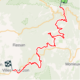
![](/images/other/stat-length.png)
![Tocht Mountainbike Aurel - Ventoux Sud - Villes sur Auzon - Photo](https://media.geolcdn.com/t/1900/400/ext.pjpeg?maxdim=2&url=https%3A%2F%2Fstatic1.geolcdn.com%2Fsiteimages%2Fupload%2Ffiles%2F1524743154velo.jpg)
Ventoux Sud - Villes sur Auzon
tracegps
Gebruiker
![Lengte](/images/other/stat-length.png)
![Max. hoogte](https://static1.geolcdn.com/siteimages/upload/files/1508320355ic_sort_altitude_max_24dp.png)
![Positief hoogteverschil](https://static1.geolcdn.com/siteimages/upload/files/1508320355ic_sort_den_pos_24dp.png)
![Km-Effort](/images/other/stat-length.png)
![Min. hoogte](https://static1.geolcdn.com/siteimages/upload/files/1508320355ic_sort_altitude_min_24dp.png)
![Negatief hoogteverschil](https://static1.geolcdn.com/siteimages/upload/files/1508320355ic_sort_den_neg_24dp.png)
![Boucle](https://static1.geolcdn.com/siteimages/upload/files/16400158638029165_repeat_loop_refresh_sync_direction_icon.png)
![Mountainbike](https://static1.geolcdn.com/sitytour/trail-icons/202.png)
4h00
Moeilijkheid : Medium
![Scan deze QR-code om de tocht te openen in de SityTrail-applicatie](https://capi.geolives.com/qq0zvz2zws4bq2lad0pu/sitytour/trails/101563/qr.png?size=200)
Gratisgps-wandelapplicatie
Over ons
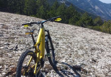
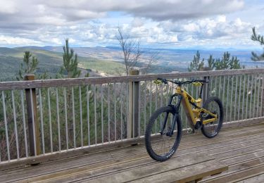
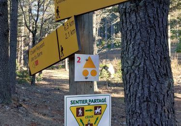
Tocht Mountainbike van 36 km beschikbaar op Provence-Alpes-Côte d'Azur, Vaucluse, Aurel. Deze tocht wordt voorgesteld door tracegps.
Beschrijving
Du fait que cette balade est un aller simple en descente (nécessité de laisser un véhicule à chaque extrémité), elle est facile physiquement et ne comporte pas de grandes difficulté techniques. Bref un must pour se faire le Ventoux en famille !
Plaatsbepaling
Opmerkingen
Wandeltochten in de omgeving
![Tocht Stappen Beaumont-du-Ventoux - Le Ventoux - Corniche Nord - Photo](https://media.geolcdn.com/t/375/260/ext.jpg?maxdim=2&url=https%3A%2F%2Fservices.sitytrail.com%2FGeolivesWS%2FDownloadMedia.ashx%3FTrailID%3D105329%26Media%3D9023_2.jpg)
![Stappen Stappen](https://static1.geolcdn.com/sitytour/trail-icons/101.png)
Stappen
![](/images/other/stat-length.png)
![](https://static1.geolcdn.com/siteimages/upload/files/16400158638029165_repeat_loop_refresh_sync_direction_icon.png)
![Tocht Stappen Aurel - Couleurs d'automne au Ventouret - Photo](https://media.geolcdn.com/t/375/260/f50ad772-5dc0-43d8-abdd-ff56e03658d4.jpg&format=jpg&maxdim=2)
![Stappen Stappen](https://static1.geolcdn.com/sitytour/trail-icons/101.png)
Stappen
![](/images/other/stat-length.png)
![](https://static1.geolcdn.com/siteimages/upload/files/16400158638029165_repeat_loop_refresh_sync_direction_icon.png)
![Tocht Stappen Aurel - Font de Margot / Jas Forest - Photo](https://media.geolcdn.com/t/375/260/51d381e6-a154-4b24-b0ab-373d50da5f32.jpg&format=jpg&maxdim=2)
![Stappen Stappen](https://static1.geolcdn.com/sitytour/trail-icons/101.png)
Stappen
![](/images/other/stat-length.png)
![](https://static1.geolcdn.com/siteimages/upload/files/16400158638029165_repeat_loop_refresh_sync_direction_icon.png)
![Tocht Stappen Bédoin - Sur les traces du reboisement du Ventoux 1860 - Photo](https://media.geolcdn.com/t/375/260/fa234f56-c4fe-4d00-97d6-2ca9e6744a73.jpg&format=jpg&maxdim=2)
![Stappen Stappen](https://static1.geolcdn.com/sitytour/trail-icons/101.png)
Stappen
![](/images/other/stat-length.png)
![](https://static1.geolcdn.com/siteimages/upload/files/16400158638029165_repeat_loop_refresh_sync_direction_icon.png)
![Tocht Mountainbike Bédoin - Frache, crête de la Tune et Ventouret - Photo](https://media.geolcdn.com/t/375/260/effad160-5fe6-4dec-8989-b60dc094dbb1.jpg&format=jpg&maxdim=2)
![Mountainbike Mountainbike](https://static1.geolcdn.com/sitytour/trail-icons/202.png)
Mountainbike
![](/images/other/stat-length.png)
![](https://static1.geolcdn.com/siteimages/upload/files/16400158638029165_repeat_loop_refresh_sync_direction_icon.png)
![Tocht Mountainbike Bédoin - Randuro sous les sapins blancs - Photo](https://media.geolcdn.com/t/375/260/b0bac01d-ef10-47db-928b-ff65b8d41793.jpg&format=jpg&maxdim=2)
![Mountainbike Mountainbike](https://static1.geolcdn.com/sitytour/trail-icons/202.png)
Mountainbike
![](/images/other/stat-length.png)
![](https://static1.geolcdn.com/siteimages/upload/files/16400158638029165_repeat_loop_refresh_sync_direction_icon.png)
![Tocht Stappen Bédoin - Sur les Traces du Père Noël 🎅 - Photo](https://media.geolcdn.com/t/375/260/09583966-25c5-4863-b43d-4db2ee326b10.jpg&format=jpg&maxdim=2)
![Stappen Stappen](https://static1.geolcdn.com/sitytour/trail-icons/101.png)
Stappen
![](/images/other/stat-length.png)
![](https://static1.geolcdn.com/siteimages/upload/files/16400158638029165_repeat_loop_refresh_sync_direction_icon.png)
![Tocht Mountainbike Bédoin - Enduro Lilou Collet de Robin - Photo](https://media.geolcdn.com/t/375/260/5b277d16-82be-4683-8302-c0071eeba31c.jpg&format=jpg&maxdim=2)
![Mountainbike Mountainbike](https://static1.geolcdn.com/sitytour/trail-icons/202.png)
Mountainbike
![](/images/other/stat-length.png)
![](https://static1.geolcdn.com/siteimages/upload/files/16400158638029165_repeat_loop_refresh_sync_direction_icon.png)
![Tocht Mountainbike Bédoin - Enduro les Pins Noirs - Photo](https://media.geolcdn.com/t/375/260/2664f93b-d28f-4f7e-87bb-83b490384099.jpg&format=jpg&maxdim=2)
![Mountainbike Mountainbike](https://static1.geolcdn.com/sitytour/trail-icons/202.png)
Mountainbike
![](/images/other/stat-length.png)
![](https://static1.geolcdn.com/siteimages/upload/files/16400158638029165_repeat_loop_refresh_sync_direction_icon.png)