![](/images/other/stat-length.png)
![Tocht Mountainbike Aix-en-Provence - Le Meilleur du Montaiguet - Photo](https://media.geolcdn.com/t/1900/400/ext.pjpeg?maxdim=2&url=https%3A%2F%2Fservices.sitytrail.com%2FGeolivesWS%2FDownloadMedia.ashx%3FTrailID%3D101371%26Media%3D1118_1.jpg)
Le Meilleur du Montaiguet
tracegps
Gebruiker
![Lengte](/images/other/stat-length.png)
Lengte
25 km
![Max. hoogte](https://static1.geolcdn.com/siteimages/upload/files/1508320355ic_sort_altitude_max_24dp.png)
Max. hoogte
326 m
![Positief hoogteverschil](https://static1.geolcdn.com/siteimages/upload/files/1508320355ic_sort_den_pos_24dp.png)
Positief hoogteverschil
673 m
![Km-Effort](/images/other/stat-length.png)
Km-Effort
34 km
![Min. hoogte](https://static1.geolcdn.com/siteimages/upload/files/1508320355ic_sort_altitude_min_24dp.png)
Min. hoogte
131 m
![Negatief hoogteverschil](https://static1.geolcdn.com/siteimages/upload/files/1508320355ic_sort_den_neg_24dp.png)
Negatief hoogteverschil
673 m
![Boucle](https://static1.geolcdn.com/siteimages/upload/files/16400158638029165_repeat_loop_refresh_sync_direction_icon.png)
Boucle
Ja
Datum van aanmaak :
2014-12-10 00:00:00.0
Laatste wijziging :
2014-12-10 00:00:00.0
![Mountainbike](https://static1.geolcdn.com/sitytour/trail-icons/202.png)
1h45
Moeilijkheid : Moeilijk
![Scan deze QR-code om de tocht te openen in de SityTrail-applicatie](https://capi.geolives.com/qq0zvz2zws4bq2lad0pu/sitytour/trails/101371/qr.png?size=200)
Gratisgps-wandelapplicatie
Over ons
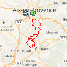
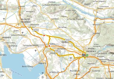
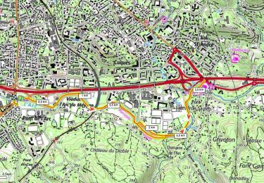
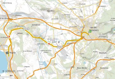
Tocht Mountainbike van 25 km beschikbaar op Provence-Alpes-Côte d'Azur, Bouches-du-Rhône, Aix-en-Provence. Deze tocht wordt voorgesteld door tracegps.
Beschrijving
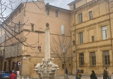
Au départ de Pont de l'Arc, une boucle VTT de 25 km qui emprunte les meilleurs sentiers du Montaiguet et des collines de Bouc. Retour par les bords de l'Arc.
Plaatsbepaling
Land:
France
Regio :
Provence-Alpes-Côte d'Azur
Departement/Provincie :
Bouches-du-Rhône
Gemeente :
Aix-en-Provence
Locatie:
Unknown
Vertrek:(Dec)
Vertrek:(UTM)
696818 ; 4820564 (31T) N.
Opmerkingen
Wandeltochten in de omgeving
![Tocht Stappen Aix-en-Provence - Aix - Tour César 8/11/2020 - Photo](https://media.geolcdn.com/t/375/260/ext.jpg?maxdim=2&url=https%3A%2F%2Fstatic1.geolcdn.com%2Fsiteimages%2Fupload%2Ffiles%2F1553511878bg_sport_marche.png)
![Stappen Stappen](https://static1.geolcdn.com/sitytour/trail-icons/101.png)
Aix - Tour César 8/11/2020
Stappen
Gemakkelijk
(1)
Aix-en-Provence,
Provence-Alpes-Côte d'Azur,
Bouches-du-Rhône,
France
![](/images/other/stat-length.png)
15,6 km | 19,6 km-effort
3h 26min
![](https://static1.geolcdn.com/siteimages/upload/files/16400158638029165_repeat_loop_refresh_sync_direction_icon.png)
Ja
![Tocht Stappen Aix-en-Provence - Aix En Provence - St Beaume - Photo](https://media.geolcdn.com/t/375/260/ext.jpg?maxdim=2&url=https%3A%2F%2Fstatic1.geolcdn.com%2Fsiteimages%2Fupload%2Ffiles%2F1553511878bg_sport_marche.png)
![Stappen Stappen](https://static1.geolcdn.com/sitytour/trail-icons/101.png)
Aix En Provence - St Beaume
Stappen
Moeilijk
(1)
Aix-en-Provence,
Provence-Alpes-Côte d'Azur,
Bouches-du-Rhône,
France
![](/images/other/stat-length.png)
65 km | 94 km-effort
19h 29min
![](https://static1.geolcdn.com/siteimages/upload/files/16400158638029165_repeat_loop_refresh_sync_direction_icon.png)
Neen
![Tocht sport Aix-en-Provence - 20240915 petit tour à Aix-en-Provence - Photo](https://media.geolcdn.com/t/375/260/a715f7cb-d380-4af1-8823-9e0c07f9878d.jpg&format=jpg&maxdim=2)
20240915 petit tour à Aix-en-Provence
sport
Heel gemakkelijk
Aix-en-Provence,
Provence-Alpes-Côte d'Azur,
Bouches-du-Rhône,
France
![](/images/other/stat-length.png)
7,8 km | 8,7 km-effort
Onbekend
![](https://static1.geolcdn.com/siteimages/upload/files/16400158638029165_repeat_loop_refresh_sync_direction_icon.png)
Ja
![Tocht Mountainbike Le Tholonet - Plateau de Bibémus - Aix-en-Provence - Photo](https://media.geolcdn.com/t/375/260/ext.jpg?maxdim=2&url=https%3A%2F%2Fservices.sitytrail.com%2FGeolivesWS%2FDownloadMedia.ashx%3FTrailID%3D104022%26Media%3D6984_6.jpg)
![Mountainbike Mountainbike](https://static1.geolcdn.com/sitytour/trail-icons/202.png)
Plateau de Bibémus - Aix-en-Provence
Mountainbike
Medium
Le Tholonet,
Provence-Alpes-Côte d'Azur,
Bouches-du-Rhône,
France
![](/images/other/stat-length.png)
10,6 km | 14 km-effort
1h 0min
![](https://static1.geolcdn.com/siteimages/upload/files/16400158638029165_repeat_loop_refresh_sync_direction_icon.png)
Ja
![Tocht Stappen Aix-en-Provence - Pont Arc-Montaiguet-Pont Arc - Photo](https://media.geolcdn.com/t/375/260/ext.jpg?maxdim=2&url=https%3A%2F%2Fstatic1.geolcdn.com%2Fsiteimages%2Fupload%2Ffiles%2F1553511878bg_sport_marche.png)
![Stappen Stappen](https://static1.geolcdn.com/sitytour/trail-icons/101.png)
Pont Arc-Montaiguet-Pont Arc
Stappen
Gemakkelijk
(1)
Aix-en-Provence,
Provence-Alpes-Côte d'Azur,
Bouches-du-Rhône,
France
![](/images/other/stat-length.png)
5,5 km | 7,7 km-effort
1h 17min
![](https://static1.geolcdn.com/siteimages/upload/files/16400158638029165_repeat_loop_refresh_sync_direction_icon.png)
Ja
![Tocht Stappen Aix-en-Provence - Aix-en-Provence Quartier Mazarine - Photo](https://media.geolcdn.com/t/375/260/289ee896-e0b6-4d50-bed2-aa1ea5e01c33.jpg&format=jpg&maxdim=2)
![Stappen Stappen](https://static1.geolcdn.com/sitytour/trail-icons/101.png)
Aix-en-Provence Quartier Mazarine
Stappen
Gemakkelijk
Aix-en-Provence,
Provence-Alpes-Côte d'Azur,
Bouches-du-Rhône,
France
![](/images/other/stat-length.png)
3,6 km | 4,1 km-effort
55min
![](https://static1.geolcdn.com/siteimages/upload/files/16400158638029165_repeat_loop_refresh_sync_direction_icon.png)
Ja
![Wegfiets Wegfiets](https://static1.geolcdn.com/sitytour/trail-icons/201.png)
Aix Pelissanne 700m+
Wegfiets
Zeer moeilijk
Aix-en-Provence,
Provence-Alpes-Côte d'Azur,
Bouches-du-Rhône,
France
![](/images/other/stat-length.png)
66 km | 75 km-effort
4h 33min
![](https://static1.geolcdn.com/siteimages/upload/files/16400158638029165_repeat_loop_refresh_sync_direction_icon.png)
Ja
![Stappen Stappen](https://static1.geolcdn.com/sitytour/trail-icons/101.png)
Bord de l'Arc, Pont de L'Arc au Pont des 3 Sautets
Stappen
Medium
Aix-en-Provence,
Provence-Alpes-Côte d'Azur,
Bouches-du-Rhône,
France
![](/images/other/stat-length.png)
6,9 km | 7,6 km-effort
1h 43min
![](https://static1.geolcdn.com/siteimages/upload/files/16400158638029165_repeat_loop_refresh_sync_direction_icon.png)
Ja
![Andere activiteiten Andere activiteiten](https://static1.geolcdn.com/sitytour/trail-icons/900.png)
Voie SNCF Aix Rognac
Andere activiteiten
Heel gemakkelijk
Aix-en-Provence,
Provence-Alpes-Côte d'Azur,
Bouches-du-Rhône,
France
![](/images/other/stat-length.png)
26 km | 29 km-effort
Onbekend
![](https://static1.geolcdn.com/siteimages/upload/files/16400158638029165_repeat_loop_refresh_sync_direction_icon.png)
Neen