![](/images/other/stat-length.png)
![Tocht Stappen Gourbit - Etangs d'Artax - Photo](https://media.geolcdn.com/t/1900/400/ext.pjpeg?maxdim=2&url=https%3A%2F%2Fservices.sitytrail.com%2FGeolivesWS%2FDownloadMedia.ashx%3FTrailID%3D101253%26Media%3D743_1.jpg)
Etangs d'Artax
tracegps
Gebruiker
![Lengte](/images/other/stat-length.png)
Lengte
3,8 km
![Max. hoogte](https://static1.geolcdn.com/siteimages/upload/files/1508320355ic_sort_altitude_max_24dp.png)
Max. hoogte
1707 m
![Positief hoogteverschil](https://static1.geolcdn.com/siteimages/upload/files/1508320355ic_sort_den_pos_24dp.png)
Positief hoogteverschil
788 m
![Km-Effort](/images/other/stat-length.png)
Km-Effort
11,7 km
![Min. hoogte](https://static1.geolcdn.com/siteimages/upload/files/1508320355ic_sort_altitude_min_24dp.png)
Min. hoogte
913 m
![Negatief hoogteverschil](https://static1.geolcdn.com/siteimages/upload/files/1508320355ic_sort_den_neg_24dp.png)
Negatief hoogteverschil
6 m
![Boucle](https://static1.geolcdn.com/siteimages/upload/files/16400158638029165_repeat_loop_refresh_sync_direction_icon.png)
Boucle
Neen
Datum van aanmaak :
2014-12-10 00:00:00.0
Laatste wijziging :
2014-12-10 00:00:00.0
![Stappen](https://static1.geolcdn.com/sitytour/trail-icons/101.png)
4h00
Moeilijkheid : Moeilijk
![Scan deze QR-code om de tocht te openen in de SityTrail-applicatie](https://capi.geolives.com/qq0zvz2zws4bq2lad0pu/sitytour/trails/101253/qr.png?size=200)
Gratisgps-wandelapplicatie
Over ons
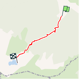
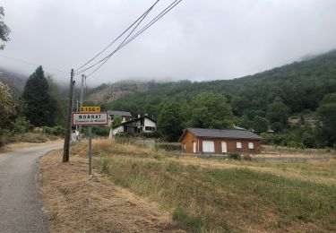
Tocht Stappen van 3,8 km beschikbaar op Occitanië, Ariège, Gourbit. Deze tocht wordt voorgesteld door tracegps.
Beschrijving
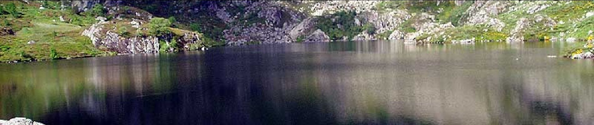
Belle randonnée, dans un cadre agréable et loin de la foule avec un lac sympa et accessible à la clef. En plus, on part d'un village merveilleux, Gourbit, le nombril de l'Ariège ! On trouve toutes les explications sur Montagne Cool
Plaatsbepaling
Land:
France
Regio :
Occitanië
Departement/Provincie :
Ariège
Gemeente :
Gourbit
Locatie:
Unknown
Vertrek:(Dec)
Vertrek:(UTM)
380108 ; 4743489 (31T) N.
Opmerkingen
Wandeltochten in de omgeving
![Tocht Stappen Rabat-les-Trois-Seigneurs - Pyrénées-120910 - EtangBleu - Photo](https://media.geolcdn.com/t/375/260/ext.jpg?maxdim=2&url=https%3A%2F%2Fservices.sitytrail.com%2FGeolivesWS%2FDownloadMedia.ashx%3FTrailID%3D154212%26Media%3D20120910120731.jpeg)
![Stappen Stappen](https://static1.geolcdn.com/sitytour/trail-icons/101.png)
Pyrénées-120910 - EtangBleu
Stappen
Medium
(1)
Rabat-les-Trois-Seigneurs,
Occitanië,
Ariège,
France
![](/images/other/stat-length.png)
11,9 km | 23 km-effort
7h 45min
![](https://static1.geolcdn.com/siteimages/upload/files/16400158638029165_repeat_loop_refresh_sync_direction_icon.png)
Ja
![Tocht Stappen Gourbit - 04/06/2014 Rando Etang d'Artax - Photo](https://media.geolcdn.com/t/375/260/ext.jpg?maxdim=2&url=https%3A%2F%2Fservices.sitytrail.com%2FGeolivesWS%2FDownloadMedia.ashx%3FTrailID%3D308062%26Media%3D20140601132627.jpg)
![Stappen Stappen](https://static1.geolcdn.com/sitytour/trail-icons/101.png)
04/06/2014 Rando Etang d'Artax
Stappen
Moeilijk
(1)
Gourbit,
Occitanië,
Ariège,
France
![](/images/other/stat-length.png)
10,8 km | 24 km-effort
2h 53min
![](https://static1.geolcdn.com/siteimages/upload/files/16400158638029165_repeat_loop_refresh_sync_direction_icon.png)
Ja
![Tocht Stappen Rabat-les-Trois-Seigneurs - Cirque D'Embans - Photo](https://media.geolcdn.com/t/375/260/ext.jpg?maxdim=2&url=https%3A%2F%2Fstatic1.geolcdn.com%2Fsiteimages%2Fupload%2Ffiles%2F1553511878bg_sport_marche.png)
![Stappen Stappen](https://static1.geolcdn.com/sitytour/trail-icons/101.png)
Cirque D'Embans
Stappen
Medium
(2)
Rabat-les-Trois-Seigneurs,
Occitanië,
Ariège,
France
![](/images/other/stat-length.png)
8,8 km | 18,4 km-effort
3h 52min
![](https://static1.geolcdn.com/siteimages/upload/files/16400158638029165_repeat_loop_refresh_sync_direction_icon.png)
Ja
![Tocht Stappen Surba - Tour du roc de Sédour - Photo](https://media.geolcdn.com/t/375/260/0a6f46ec-50b3-4cd7-935e-a334e1ae38c6.jpg&format=jpg&maxdim=2)
![Stappen Stappen](https://static1.geolcdn.com/sitytour/trail-icons/101.png)
Tour du roc de Sédour
Stappen
Gemakkelijk
Surba,
Occitanië,
Ariège,
France
![](/images/other/stat-length.png)
13,1 km | 19,5 km-effort
4h 10min
![](https://static1.geolcdn.com/siteimages/upload/files/16400158638029165_repeat_loop_refresh_sync_direction_icon.png)
Ja
![Tocht Elektrische fiets Niaux - Niaux - Photo](https://media.geolcdn.com/t/375/260/2925b5db-f18d-4157-bbef-94a57335fc75.jpg&format=jpg&maxdim=2)
![Elektrische fiets Elektrische fiets](https://static1.geolcdn.com/sitytour/trail-icons/205.png)
Niaux
Elektrische fiets
Heel gemakkelijk
Niaux,
Occitanië,
Ariège,
France
![](/images/other/stat-length.png)
13,8 km | 21 km-effort
51min
![](https://static1.geolcdn.com/siteimages/upload/files/16400158638029165_repeat_loop_refresh_sync_direction_icon.png)
Ja
![Tocht Elektrische fiets Niaux - Château Miglos - Photo](https://media.geolcdn.com/t/375/260/8bba2701-86a9-409d-bc1b-998f1da97a1d.jpg&format=jpg&maxdim=2)
![Elektrische fiets Elektrische fiets](https://static1.geolcdn.com/sitytour/trail-icons/205.png)
Château Miglos
Elektrische fiets
Heel gemakkelijk
Niaux,
Occitanië,
Ariège,
France
![](/images/other/stat-length.png)
8,1 km | 11 km-effort
45min
![](https://static1.geolcdn.com/siteimages/upload/files/16400158638029165_repeat_loop_refresh_sync_direction_icon.png)
Neen
![Tocht Te voet Lapège - Lapège et Pladetis - Photo](https://media.geolcdn.com/t/375/260/acf32a31-72a6-4e31-a909-32a8fa5a01b2.jpeg&format=jpg&maxdim=2)
![Te voet Te voet](https://static1.geolcdn.com/sitytour/trail-icons/100.png)
Lapège et Pladetis
Te voet
Gemakkelijk
Lapège,
Occitanië,
Ariège,
France
![](/images/other/stat-length.png)
10,1 km | 18,8 km-effort
4h 16min
![](https://static1.geolcdn.com/siteimages/upload/files/16400158638029165_repeat_loop_refresh_sync_direction_icon.png)
Neen
![Tocht Te voet Gourbit - Étang d'Artax - Photo](https://media.geolcdn.com/t/375/260/b2f84de2-fa0a-4b97-b201-829b16672ace.jpeg&format=jpg&maxdim=2)
![Te voet Te voet](https://static1.geolcdn.com/sitytour/trail-icons/100.png)
Étang d'Artax
Te voet
Gemakkelijk
Gourbit,
Occitanië,
Ariège,
France
![](/images/other/stat-length.png)
4,3 km | 12,3 km-effort
2h 47min
![](https://static1.geolcdn.com/siteimages/upload/files/16400158638029165_repeat_loop_refresh_sync_direction_icon.png)
Neen
![Tocht Stappen Rabat-les-Trois-Seigneurs - pic du Pioulou en boucle - Photo](https://media.geolcdn.com/t/375/260/e8bfc997-31ac-4ff2-b0d1-e43d1083f5c2.jpg&format=jpg&maxdim=2)
![Stappen Stappen](https://static1.geolcdn.com/sitytour/trail-icons/101.png)
pic du Pioulou en boucle
Stappen
Moeilijk
Rabat-les-Trois-Seigneurs,
Occitanië,
Ariège,
France
![](/images/other/stat-length.png)
15,7 km | 32 km-effort
6h 45min
![](https://static1.geolcdn.com/siteimages/upload/files/16400158638029165_repeat_loop_refresh_sync_direction_icon.png)
Neen