Tocht Mountainbike Le Bonhomme - Les Bagenelles - Photo
 tracegps
tracegps

Gebruiker

© OpenStreetMap contributors
Lengte
Lengte
13 km
Max. hoogte
Max. hoogte
987 m
Positief hoogteverschil
418 m
Km-Effort
Km-Effort  
18,6 km
Min. hoogte
Min. hoogte
664 m
Negatief hoogteverschil
421 m
Boucle
Boucle
Ja
Datum van aanmaak :
2014-12-10 00:00:00.0
Laatste wijziging :
2014-12-10 00:00:00.0

(0 Bericht)

Mountainbike
Mountainbike
1h19
Moeilijkheid : Medium

Scan deze QR-code om de tocht te openen in de SityTrail-applicatie

Gratisgps-wandelapplicatie

Logo SityTrail SityTrail

IGN / Geografische instituten

SityTrail uit de App Store downloaden SityTrail uit Google Play downloaden

Logo SityTrail SityTrail World

De wereld gaat voor u open

SityTrail uit de App Store downloaden SityTrail uit Google Play downloaden SityTrail op Huawei AppGallery downloaden

Over ons

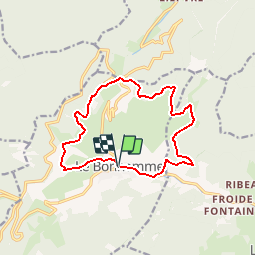
Tocht Mountainbike van 13 km beschikbaar op Grand Est, Haut-Rhin, Le Bonhomme. Deze tocht wordt voorgesteld door tracegps.

Beschrijving

Le départ de ce circuit se situe à l'intersection de la N415 et de la D48. Les premières balises sont un peu délavés par le soleil. Le circuit démarre par une longue montée sur macadam jusqu'à un carrefour marqué par une croix. On rejoint alors le circuit W1. Petites montées et descentes jusqu'au col des Bagenelles. De là une montée raide étagée en 3 parties, puis une longue descente la plupart du temps sur macadam aussi. Pas de difficultés techniques à signaler. D'autres infos ICI

Hoogteprofiel

Foto's

Plaatsbepaling

Land:
France
Regio :
Grand Est
Departement/Provincie :
Haut-Rhin
Gemeente :
Le Bonhomme
Locatie:
Unknown
Vertrek:(Dec)
Vertrek:(UTM)
359754 ; 5337171 (32U) N.

Wandeltochten in de omgeving

Tocht Stappen Le Bonhomme - Tête des faux . - Photo
Stappen
heurtinpatrick

Stappen

Medium
(1)
Le Bonhomme, Grand Est, Haut-Rhin, France
11,9 km | 16,6 km-effort
3h 46min
Ja
Tocht Stappen Lapoutroie - 2012-06-16 Marche aux Alisiers Orbey - Photo
Stappen
GUIDE
holtzv

Stappen

Gemakkelijk
(2)
Lapoutroie, Grand Est, Haut-Rhin, France
11,1 km | 16,6 km-effort
2h 49min
Ja
Tocht Mountainbike Orbey - Lac Blanc  - Têtes des Faux - Photo
Mountainbike
tracegps

Mountainbike

Medium
(1)
Orbey, Grand Est, Haut-Rhin, France
15,3 km | 21 km-effort
1h 0min
Ja
Tocht Stappen Le Bonhomme - Le Bonhomme - Circuit du village - Photo
Stappen
GUIDE
Desrumaux

Stappen

Gemakkelijk
(1)
Le Bonhomme, Grand Est, Haut-Rhin, France
3 km | 5,3 km-effort
1h 30min
Ja
Tocht Stappen Sainte-Marie-aux-Mines - 2021-02-14 Marche Bagenelles Brezouard Fuste de Etoile - Photo
Stappen
GUIDE
holtzv

Stappen

Zeer moeilijk
Sainte-Marie-aux-Mines, Grand Est, Haut-Rhin, France
17,1 km | 27 km-effort
6h 6min
Ja
Tocht Stappen Lapoutroie - 2020-07-19 Marche Étang du Devin Col Calvaire Tête des Faux - Photo
Stappen
GUIDE
holtzv

Stappen

Heel gemakkelijk
Lapoutroie, Grand Est, Haut-Rhin, France
14,2 km | 22 km-effort
3h 27min
Ja
Tocht Mountainbike Orbey - Welche E Bike Tour 2024 - Photo
Mountainbike
duchaine.nicolas

Mountainbike

Medium
Orbey, Grand Est, Haut-Rhin, France
35 km | 51 km-effort
2h 17min
Ja
Tocht Stappen Orbey - Col du Calvaire ➡️ Lac Blanc  - Photo
Stappen
nana1643

Stappen

Medium
Orbey, Grand Est, Haut-Rhin, France
8,6 km | 12,8 km-effort
3h 9min
Ja
Tocht Elektrische fiets Le Bonhomme - Lac blanc col de la schlucht Six fours lac noir - Photo
Elektrische fiets
apa

Elektrische fiets

Medium
Le Bonhomme, Grand Est, Haut-Rhin, France
39 km | 49 km-effort
2h 57min
Ja


Sluiten
Mijn abonnementen