Tocht Stappen Nassogne - NASSOGNE (St-Monon) - Photo

NASSOGNE (St-Monon)

 GerardBouche
GerardBouche

Gebruiker

© OpenStreetMap contributors
Lengte
Lengte
9,5 km
Max. hoogte
Max. hoogte
410 m
Positief hoogteverschil
279 m
Km-Effort
Km-Effort  
13,2 km
Min. hoogte
Min. hoogte
233 m
Negatief hoogteverschil
282 m
Boucle
Boucle
Ja
Datum van aanmaak :
2018-08-19 07:27:05.78
Laatste wijziging :
2018-08-19 07:27:05.78

(0 Bericht)

Stappen
Stappen
2h47
Moeilijkheid : Gemakkelijk

Scan deze QR-code om de tocht te openen in de SityTrail-applicatie

Gratisgps-wandelapplicatie

Logo SityTrail SityTrail

IGN / Geografische instituten

SityTrail uit de App Store downloaden SityTrail uit Google Play downloaden

Logo SityTrail SityTrail World

De wereld gaat voor u open

SityTrail uit de App Store downloaden SityTrail uit Google Play downloaden SityTrail op Huawei AppGallery downloaden

Over ons

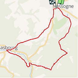
Tocht Stappen van 9,5 km beschikbaar op Wallonië, Luxemburg, Nassogne. Deze tocht wordt voorgesteld door GerardBouche.

Beschrijving

Très belle balade forestière au départ de la maison communale vers le village de Masbourg ... le retour par la rive gauche de la Masblette, un passage à gué et le Tier des Gattes.

Hoogteprofiel

Foto's

Plaatsbepaling

Land:
Belgium
Regio :
Wallonië
Departement/Provincie :
Luxemburg
Gemeente :
Nassogne
Locatie:
Nassogne
Vertrek:(Dec)
Vertrek:(UTM)
667373 ; 5555551 (31U) N.

Wandeltochten in de omgeving

Tocht Stappen Tellin - GG-Lu-13_Grupont - Poix-Saint-Hubert - Photo
Stappen
PRO

Stappen

Zeer moeilijk
(2)
Tellin, Wallonië, Luxemburg, Belgium
26 km | 34 km-effort
7h 23min
Neen
Tocht Stappen Tellin - Balade à Grupont - Photo
Stappen
GUIDE
Desrumaux

Stappen

Gemakkelijk
(1)
Tellin, Wallonië, Luxemburg, Belgium
8,4 km | 11,9 km-effort
2h 33min
Ja
Tocht Stappen Tellin - Grupont - Promenade du Bois du Machi - Photo
Stappen
GUIDE+

Stappen

Medium
(1)
Tellin, Wallonië, Luxemburg, Belgium
8,6 km | 12,6 km-effort
2h 37min
Ja
Tocht Mountainbike Nassogne - Nassogne - Circuit VTT rouge 4 - Photo
Mountainbike
GUIDE+

Mountainbike

Moeilijk
(1)
Nassogne, Wallonië, Luxemburg, Belgium
26 km | 36 km-effort
2h 16min
Ja
Tocht Stappen Nassogne - Grune - Promenade du Chevenys (NG 11) - Photo
Stappen
GUIDE+

Stappen

Medium
(3)
Nassogne, Wallonië, Luxemburg, Belgium
8,4 km | 11,6 km-effort
2h 27min
Ja
Tocht Stappen Nassogne - Grune - Promenade des Prés (NG 10) - Photo
Stappen
GUIDE+

Stappen

Gemakkelijk
(1)
Nassogne, Wallonië, Luxemburg, Belgium
4,4 km | 5,3 km-effort
1h 10min
Ja
Tocht Stappen Nassogne - Forrières/Lesterny - Promenade Saint-Martin (NG 08) - Photo
Stappen
GUIDE+

Stappen

Medium
(4)
Nassogne, Wallonië, Luxemburg, Belgium
7,3 km | 9 km-effort
1h 57min
Ja
Tocht Stappen Nassogne - Forrières - Promenade de Cocher (NG 07) - Photo
Stappen
GUIDE+

Stappen

Medium
(3)
Nassogne, Wallonië, Luxemburg, Belgium
5,4 km | 6,7 km-effort
1h 28min
Ja
Tocht Stappen Nassogne - Ambly - Promenade de Javingue (NG 02) - Photo
Stappen
GUIDE+

Stappen

Medium
(7)
Nassogne, Wallonië, Luxemburg, Belgium
9 km | 11,6 km-effort
2h 28min
Ja


Sluiten
Mijn abonnementen