Home
World
NEW
Premium
Winkel
tochten
Artikels
Help - ondersteuning
Français
English
Nederlands
Español
Italiano
Deutsch
Aansluiting
Home
World
Premium
Winkel
tochten
Artikels
Help - ondersteuning
SityTrail
>
POI's
>
GCJKK3
SityTrail
>
POI's
>
GCJKK3
GCJKK3
Beschrijving
Col Du Mont Cenis by waynerpra
Foto's
Ontdek GCJKK3 met de volgende tochten...
tracegps
Le Fort de la Batterie
Stappen
Medium
Marthod, Auvergne-Rhône-Alpes, Savoie, France
6,5 km | 13,3 km-effort
2h 30min
Ja
tracegps
Gebruiker
©
OpenStreetMap
contributors
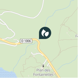
Plaatsbepaling
Land:
France
Regio :
Auvergne-Rhône-Alpes
Departement/Provincie :
Savoie
Gemeente :
Val-Cenis
Locatie:
Lanslebourg-Mont-Cenis
Plaatsbepaling
45.24345 / 6.94925
Datum van aanmaak :
2018-04-09 12:16:14.987
Laatste wijziging
2018-04-09 12:16:14.987
(0 Bericht)
Opmerkingen
Gelieve in te loggen om een commentaar of een beoordeling achter te laten
POI's in de buurt
tracegps
GCJKK3
VAL-CENIS
tracegps
GCJKK3
VAL-CENIS
tracegps
GCJKK3
VAL-CENIS
tracegps
GCJKK3
VAL-CENIS
tracegps
GCJKK3
VAL-CENIS
tracegps
GCJKK3
VAL-CENIS
tracegps
GCJKK3
VAL-CENIS
tracegps
GCJKK3
VAL-CENIS
Sluiten
Mijn abonnementen