Home
World
NEW
Premium
Winkel
tochten
Artikels
Help - ondersteuning
Français
English
Nederlands
Español
Italiano
Deutsch
Aansluiting
Home
World
Premium
Winkel
tochten
Artikels
Help - ondersteuning
SityTrail
>
POI's
>
GCYY9H
SityTrail
>
POI's
>
GCYY9H
GCYY9H
Beschrijving
Aqueduc romain du Gier N2 by
Foto's
Ontdek GCYY9H met de volgende tochten...
tracegps
Col du Souffre et Lacs Mont-Coua
Stappen
Moeilijk
(1)
Les Allues, Auvergne-Rhône-Alpes, Savoie, France
25 km | 41 km-effort
7h 0min
Ja
tracegps
Gebruiker
©
OpenStreetMap
contributors
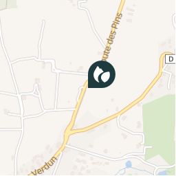
Plaatsbepaling
Land:
France
Regio :
Auvergne-Rhône-Alpes
Departement/Provincie :
Rhône
Gemeente :
Chaponost
Locatie:
Unknown
Plaatsbepaling
45.722800009 / 4.760999959000001
Datum van aanmaak :
2018-04-09 12:22:58.279
Laatste wijziging
2018-04-09 12:22:58.279
(0 Bericht)
Opmerkingen
Gelieve in te loggen om een commentaar of een beoordeling achter te laten
POI's in de buurt
tracegps
GCYY9H
CHAPONOST
tracegps
GCYY9H
CHAPONOST
tracegps
GCYY9H
CHAPONOST
tracegps
GCYY9H
CHAPONOST
tracegps
GCYY9H
CHAPONOST
tracegps
GCYY9H
CHAPONOST
tracegps
GCYY9H
CHAPONOST
tracegps
GCYY9H
CHAPONOST
Sluiten
Mijn abonnementen