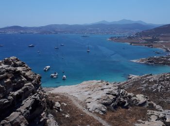
![](/images/other/stat-length.png)
Egeïsche Eilanden, Greece: Top van de beste wandelroutes, trajecten, tochten en wandelingen
Egeïsche Eilanden: Ontdek de beste tochten: 245 te voet en 12 te paard. Al deze tochten, trajecten, routes en outdoor activiteiten zijn beschikbaar in onze SityTrail-apps voor smartphones en tablets.
De beste trajecten (295)
![Tocht Te voet - Andros Routes 15 - Photo](https://media.geolcdn.com/t/350/260/320a3f32-d856-42a1-9cd6-c3bd3a456cce.jpeg&format=jpg&maxdim=2)
![Te voet Te voet](https://static1.geolcdn.com/sitytour/trail-icons/100.png)
Km
Te voet
![](/images/other/stat-length.png)
![](https://static1.geolcdn.com/siteimages/upload/files/1508320355ic_sort_den_pos_24dp.png)
![](https://static1.geolcdn.com/siteimages/upload/files/1508320355ic_sort_den_neg_24dp.png)
![](https://static1.geolcdn.com/siteimages/upload/files/16400158638029165_repeat_loop_refresh_sync_direction_icon.png)
• Trail created by Andros Routes. Symbol: red_rectangle Website: https://www.androsroutes.gr/
![Tocht Te voet - Andros Routes 15a - Photo](https://media.geolcdn.com/t/350/260/a14d5702-efda-4809-955d-545c0483c57e.jpeg&format=jpg&maxdim=2)
![Te voet Te voet](https://static1.geolcdn.com/sitytour/trail-icons/100.png)
Km
Te voet
![](/images/other/stat-length.png)
![](https://static1.geolcdn.com/siteimages/upload/files/1508320355ic_sort_den_pos_24dp.png)
![](https://static1.geolcdn.com/siteimages/upload/files/1508320355ic_sort_den_neg_24dp.png)
![](https://static1.geolcdn.com/siteimages/upload/files/16400158638029165_repeat_loop_refresh_sync_direction_icon.png)
• Trail created by Andros Routes. Symbol: red_rectangle Website: https://www.androsroutes.gr/
![Tocht Te voet - Andros Routes 17 - Photo](https://media.geolcdn.com/t/350/260/3ea9cf68-964d-42cd-bcce-620627ae00e4.jpeg&format=jpg&maxdim=2)
![Te voet Te voet](https://static1.geolcdn.com/sitytour/trail-icons/100.png)
Km
Te voet
![](/images/other/stat-length.png)
![](https://static1.geolcdn.com/siteimages/upload/files/1508320355ic_sort_den_pos_24dp.png)
![](https://static1.geolcdn.com/siteimages/upload/files/1508320355ic_sort_den_neg_24dp.png)
![](https://static1.geolcdn.com/siteimages/upload/files/16400158638029165_repeat_loop_refresh_sync_direction_icon.png)
• Trail created by Andros Routes. Symbol: red_rectangle Website: https://www.androsroutes.gr/
![Tocht Te voet - Andros Routes 10 - Photo](https://media.geolcdn.com/t/350/260/8babceff-8d5c-426f-9e4c-4a955b7453a2.jpeg&format=jpg&maxdim=2)
![Te voet Te voet](https://static1.geolcdn.com/sitytour/trail-icons/100.png)
Km
Te voet
![](/images/other/stat-length.png)
![](https://static1.geolcdn.com/siteimages/upload/files/1508320355ic_sort_den_pos_24dp.png)
![](https://static1.geolcdn.com/siteimages/upload/files/1508320355ic_sort_den_neg_24dp.png)
![](https://static1.geolcdn.com/siteimages/upload/files/16400158638029165_repeat_loop_refresh_sync_direction_icon.png)
• Trail created by Andros Routes. Symbol: red_rectangle Website: https://www.androsroutes.gr/
![Tocht Te voet - Andros Routes 5 - Photo](https://media.geolcdn.com/t/350/260/3ea9cf68-964d-42cd-bcce-620627ae00e4.jpeg&format=jpg&maxdim=2)
![Te voet Te voet](https://static1.geolcdn.com/sitytour/trail-icons/100.png)
Km
Te voet
![](/images/other/stat-length.png)
![](https://static1.geolcdn.com/siteimages/upload/files/1508320355ic_sort_den_pos_24dp.png)
![](https://static1.geolcdn.com/siteimages/upload/files/1508320355ic_sort_den_neg_24dp.png)
![](https://static1.geolcdn.com/siteimages/upload/files/16400158638029165_repeat_loop_refresh_sync_direction_icon.png)
• Trail created by Andros Routes. Symbol: red_rectangle Website: https://www.androsroutes.gr/
![Tocht Te voet - Andros Routes 18 - Photo](https://media.geolcdn.com/t/350/260/70a7c804-9701-41c4-be94-83e75bfd7b66.jpeg&format=jpg&maxdim=2)
![Te voet Te voet](https://static1.geolcdn.com/sitytour/trail-icons/100.png)
Km
Te voet
![](/images/other/stat-length.png)
![](https://static1.geolcdn.com/siteimages/upload/files/1508320355ic_sort_den_pos_24dp.png)
![](https://static1.geolcdn.com/siteimages/upload/files/1508320355ic_sort_den_neg_24dp.png)
![](https://static1.geolcdn.com/siteimages/upload/files/16400158638029165_repeat_loop_refresh_sync_direction_icon.png)
• Trail created by Andros Routes. Symbol: red_rectangle Website: https://www.androsroutes.gr/
![Tocht Te voet - Andros Routes 1 - Photo](https://media.geolcdn.com/t/350/260/70a7c804-9701-41c4-be94-83e75bfd7b66.jpeg&format=jpg&maxdim=2)
![Te voet Te voet](https://static1.geolcdn.com/sitytour/trail-icons/100.png)
Km
Te voet
![](/images/other/stat-length.png)
![](https://static1.geolcdn.com/siteimages/upload/files/1508320355ic_sort_den_pos_24dp.png)
![](https://static1.geolcdn.com/siteimages/upload/files/1508320355ic_sort_den_neg_24dp.png)
![](https://static1.geolcdn.com/siteimages/upload/files/16400158638029165_repeat_loop_refresh_sync_direction_icon.png)
• Trail created by Andros Routes. Symbol: red_rectangle Website: https://www.androsroutes.gr/
![Tocht Te voet - Andros Routes 11 - Photo](https://media.geolcdn.com/t/350/260/6909892e-51ec-4943-a3a7-329549f59973.jpeg&format=jpg&maxdim=2)
![Te voet Te voet](https://static1.geolcdn.com/sitytour/trail-icons/100.png)
Km
Te voet
![](/images/other/stat-length.png)
![](https://static1.geolcdn.com/siteimages/upload/files/1508320355ic_sort_den_pos_24dp.png)
![](https://static1.geolcdn.com/siteimages/upload/files/1508320355ic_sort_den_neg_24dp.png)
![](https://static1.geolcdn.com/siteimages/upload/files/16400158638029165_repeat_loop_refresh_sync_direction_icon.png)
• Trail created by Andros Routes. Symbol: red_rectangle Website: https://www.androsroutes.gr/
![Tocht Te voet - Andros Routes 16 - Photo](https://media.geolcdn.com/t/350/260/38a81b7b-5f15-48d9-88ff-562f4c47b63f.jpeg&format=jpg&maxdim=2)
![Te voet Te voet](https://static1.geolcdn.com/sitytour/trail-icons/100.png)
Km
Te voet
![](/images/other/stat-length.png)
![](https://static1.geolcdn.com/siteimages/upload/files/1508320355ic_sort_den_pos_24dp.png)
![](https://static1.geolcdn.com/siteimages/upload/files/1508320355ic_sort_den_neg_24dp.png)
![](https://static1.geolcdn.com/siteimages/upload/files/16400158638029165_repeat_loop_refresh_sync_direction_icon.png)
• Trail created by Andros Routes. Symbol: red_rectangle Website: https://www.androsroutes.gr/
![Tocht Te voet - Andros Routes 14 - Photo](https://media.geolcdn.com/t/350/260/fbc799c1-eea5-49a7-a7f5-f23f098bcc56.jpeg&format=jpg&maxdim=2)
![Te voet Te voet](https://static1.geolcdn.com/sitytour/trail-icons/100.png)
Km
Te voet
![](/images/other/stat-length.png)
![](https://static1.geolcdn.com/siteimages/upload/files/1508320355ic_sort_den_pos_24dp.png)
![](https://static1.geolcdn.com/siteimages/upload/files/1508320355ic_sort_den_neg_24dp.png)
![](https://static1.geolcdn.com/siteimages/upload/files/16400158638029165_repeat_loop_refresh_sync_direction_icon.png)
• Trail created by Andros Routes. Symbol: red_rectangle Website: https://www.androsroutes.gr/
![Tocht Te voet - Andros Routes 4 - Photo](https://media.geolcdn.com/t/350/260/1d4f6d94-82f0-4904-9335-aa62fec7d026.jpeg&format=jpg&maxdim=2)
![Te voet Te voet](https://static1.geolcdn.com/sitytour/trail-icons/100.png)
Km
Te voet
![](/images/other/stat-length.png)
![](https://static1.geolcdn.com/siteimages/upload/files/1508320355ic_sort_den_pos_24dp.png)
![](https://static1.geolcdn.com/siteimages/upload/files/1508320355ic_sort_den_neg_24dp.png)
![](https://static1.geolcdn.com/siteimages/upload/files/16400158638029165_repeat_loop_refresh_sync_direction_icon.png)
• Trail created by Andros Routes. Symbol: red_rectangle Website: https://www.androsroutes.gr/
![Tocht Te voet - Andros Routes 3 - Photo](https://media.geolcdn.com/t/350/260/91ada0e4-3f6e-4426-8b80-971c602833f2.jpeg&format=jpg&maxdim=2)
![Te voet Te voet](https://static1.geolcdn.com/sitytour/trail-icons/100.png)
Km
Te voet
![](/images/other/stat-length.png)
![](https://static1.geolcdn.com/siteimages/upload/files/1508320355ic_sort_den_pos_24dp.png)
![](https://static1.geolcdn.com/siteimages/upload/files/1508320355ic_sort_den_neg_24dp.png)
![](https://static1.geolcdn.com/siteimages/upload/files/16400158638029165_repeat_loop_refresh_sync_direction_icon.png)
• Trail created by Andros Routes. Symbol: red_rectangle Website: https://www.androsroutes.gr/
![Tocht Te voet - Andros Routes 2 - Photo](https://media.geolcdn.com/t/350/260/8babceff-8d5c-426f-9e4c-4a955b7453a2.jpeg&format=jpg&maxdim=2)
![Te voet Te voet](https://static1.geolcdn.com/sitytour/trail-icons/100.png)
Km
Te voet
![](/images/other/stat-length.png)
![](https://static1.geolcdn.com/siteimages/upload/files/1508320355ic_sort_den_pos_24dp.png)
![](https://static1.geolcdn.com/siteimages/upload/files/1508320355ic_sort_den_neg_24dp.png)
![](https://static1.geolcdn.com/siteimages/upload/files/16400158638029165_repeat_loop_refresh_sync_direction_icon.png)
• Trail created by Andros Routes. Symbol: red_rectangle Website: https://www.androsroutes.gr/
![Tocht Te voet - Andros Routes 8 - Photo](https://media.geolcdn.com/t/350/260/8babceff-8d5c-426f-9e4c-4a955b7453a2.jpeg&format=jpg&maxdim=2)
![Te voet Te voet](https://static1.geolcdn.com/sitytour/trail-icons/100.png)
Km
Te voet
![](/images/other/stat-length.png)
![](https://static1.geolcdn.com/siteimages/upload/files/1508320355ic_sort_den_pos_24dp.png)
![](https://static1.geolcdn.com/siteimages/upload/files/1508320355ic_sort_den_neg_24dp.png)
![](https://static1.geolcdn.com/siteimages/upload/files/16400158638029165_repeat_loop_refresh_sync_direction_icon.png)
• Trail created by Andros Routes. Symbol: red_rectangle Website: https://www.androsroutes.gr/
![Tocht Te voet - Ίος Χώρα-Agios Prokopios (via Profiti Ilias Rachi) (Μονοπάτι) - Photo](https://media.geolcdn.com/t/350/260/07a280e8-5a16-4e5d-b8a8-083862382127.jpeg&format=jpg&maxdim=2)
![Te voet Te voet](https://static1.geolcdn.com/sitytour/trail-icons/100.png)
Km
Te voet
![](/images/other/stat-length.png)
![](https://static1.geolcdn.com/siteimages/upload/files/1508320355ic_sort_den_pos_24dp.png)
![](https://static1.geolcdn.com/siteimages/upload/files/1508320355ic_sort_den_neg_24dp.png)
![](https://static1.geolcdn.com/siteimages/upload/files/16400158638029165_repeat_loop_refresh_sync_direction_icon.png)
• Symbol: 3
![Tocht Stappen Δημοτική Ενότητα Θήρας - SANTORIN - Pyrgos - Perissa - GRECE - Photo](https://media.geolcdn.com/t/350/260/9acf2e51-5ef2-4d08-a0e9-ba4ddcb18bd8.jpg&format=jpg&maxdim=2)
![Stappen Stappen](https://static1.geolcdn.com/sitytour/trail-icons/101.png)
Km
Stappen
![](/images/other/stat-length.png)
![](https://static1.geolcdn.com/siteimages/upload/files/1508320355ic_sort_den_pos_24dp.png)
![](https://static1.geolcdn.com/siteimages/upload/files/1508320355ic_sort_den_neg_24dp.png)
![](https://static1.geolcdn.com/siteimages/upload/files/16400158638029165_repeat_loop_refresh_sync_direction_icon.png)
![Tocht Stappen Δημοτική Ενότητα Θήρας - Santorin - Fira - Oia - GRECE - Photo](https://media.geolcdn.com/t/350/260/265a4e14-44f8-4a97-b693-7bd5f41e3eab.jpg&format=jpg&maxdim=2)
![Stappen Stappen](https://static1.geolcdn.com/sitytour/trail-icons/101.png)
Km
Stappen
![](/images/other/stat-length.png)
![](https://static1.geolcdn.com/siteimages/upload/files/1508320355ic_sort_den_pos_24dp.png)
![](https://static1.geolcdn.com/siteimages/upload/files/1508320355ic_sort_den_neg_24dp.png)
![](https://static1.geolcdn.com/siteimages/upload/files/16400158638029165_repeat_loop_refresh_sync_direction_icon.png)
![Tocht Stappen Δημοτική Ενότητα Οίας - Finikia-Imerovigli-Finikia - Photo](https://media.geolcdn.com/t/350/260/528a81f6-3e8b-4dab-bd62-47c0bdf8c508.jpg&format=jpg&maxdim=2)
![Stappen Stappen](https://static1.geolcdn.com/sitytour/trail-icons/101.png)
Km
Stappen
![](/images/other/stat-length.png)
![](https://static1.geolcdn.com/siteimages/upload/files/1508320355ic_sort_den_pos_24dp.png)
![](https://static1.geolcdn.com/siteimages/upload/files/1508320355ic_sort_den_neg_24dp.png)
![](https://static1.geolcdn.com/siteimages/upload/files/16400158638029165_repeat_loop_refresh_sync_direction_icon.png)
![Tocht Stappen - Chora>>monastère >> chora>>katapola - Photo](https://media.geolcdn.com/t/350/260/e5bb279e-9a59-491f-b4af-37ced39e52ef.jpg&format=jpg&maxdim=2)
![Stappen Stappen](https://static1.geolcdn.com/sitytour/trail-icons/101.png)
Km
Stappen
![](/images/other/stat-length.png)
![](https://static1.geolcdn.com/siteimages/upload/files/1508320355ic_sort_den_pos_24dp.png)
![](https://static1.geolcdn.com/siteimages/upload/files/1508320355ic_sort_den_neg_24dp.png)
![](https://static1.geolcdn.com/siteimages/upload/files/16400158638029165_repeat_loop_refresh_sync_direction_icon.png)
![Tocht Stappen - Monastiri and lighthouse in Paeos - Photo](https://media.geolcdn.com/t/350/260/f04dc56c-b587-4c02-863f-bd598b6bab77.jpg&format=jpg&maxdim=2)
![Stappen Stappen](https://static1.geolcdn.com/sitytour/trail-icons/101.png)
Km
Stappen
![](/images/other/stat-length.png)
![](https://static1.geolcdn.com/siteimages/upload/files/1508320355ic_sort_den_pos_24dp.png)
![](https://static1.geolcdn.com/siteimages/upload/files/1508320355ic_sort_den_neg_24dp.png)
![](https://static1.geolcdn.com/siteimages/upload/files/16400158638029165_repeat_loop_refresh_sync_direction_icon.png)
20 tochten weergegeven op 295
Gratisgps-wandelapplicatie
Activiteiten
Nabije regio's
- Rhodos
- Περιφερειακή Ενότητα Άνδρου
- Περιφερειακή Ενότητα Θήρας
- Περιφερειακή Ενότητα Ικαρίας
- Περιφερειακή Ενότητα Καλύμνου
- Περιφερειακή Ενότητα Καρπάθου
- Περιφερειακή Ενότητα Κέας - Κύθνου
- Περιφερειακή Ενότητα Κω
- Περιφερειακή Ενότητα Λέσβου
- Περιφερειακή Ενότητα Μήλου
- Περιφερειακή Ενότητα Μυκόνου
- Περιφερειακή Ενότητα Νάξου
- Περιφερειακή Ενότητα Πάρου
- Περιφερειακή Ενότητα Σάμου
- Περιφερειακή Ενότητα Τήνου