


11,5 km | 13,5 km-effort
Annesse-et-Beaulieu: Ontdek de beste tochten: 9 te voet. Al deze tochten, trajecten, routes en outdoor activiteiten zijn beschikbaar in onze SityTrail-apps voor smartphones en tablets.
Stappen


Stappen

Stappen

Stappen
Stappen
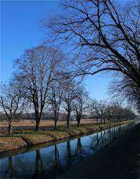
• Un peu trop de route, mais la fin de la rando sur les bords du canal est tres agréable.
Stappen
• Un peu trop de route, mais la fin de la rando sur les bords du canal est tres agréable.
Stappen
• Rando cool sans de véritable difficultés.
Stappen
Stappen
9 tochten weergegeven op 9
Gratisgps-wandelapplicatie
 SityTrail
IGN / Geografische instituten
SityTrail World
De wereld gaat voor u open