


8,4 km | 9,9 km-effort
Évreux: Ontdek de beste tochten: 42 te voet en 27 met de fiets of mountainbike. Al deze tochten, trajecten, routes en outdoor activiteiten zijn beschikbaar in onze SityTrail-apps voor smartphones en tablets.
Stappen


Stappen
Fiets
• Parcours essentiellement routier.
Fiets
• Dans la fraîcheur des sous-bois

Andere activiteiten
•
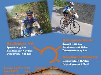
Mountainbike
Stappen

Stappen
Stappen
Stappen
Stappen

Te voet
Stappen
Stappen
Stappen
• marche

Fiets
• A VTT ou VTC, 30% de chemins non bitumés
Fiets
• 90% routes 10% chemins. Départ du carrefour Saint-Léger.
Fiets
• Au départ de la cathédrale d'Evreux, on grimpe la côte Henri Monduit vers St Michel. A travers bois et champs, on rej...
Fiets
• 3/4 sur des chemins forestiers er champêtres.
Fiets
20 tochten weergegeven op 77
Gratisgps-wandelapplicatie
 SityTrail
IGN / Geografische instituten
SityTrail World
De wereld gaat voor u open