![](/images/other/stat-length.png)
- Tochten
- Outdoor
- France
- Hauts-de-France
- Somme
- Montdidier
Montdidier, Somme: Top van de beste wandelroutes, trajecten, tochten en wandelingen
Montdidier: Ontdek de beste tochten: 6 te voet en 4 met de fiets of mountainbike. Al deze tochten, trajecten, routes en outdoor activiteiten zijn beschikbaar in onze SityTrail-apps voor smartphones en tablets.
De beste trajecten (11)
![Tocht Stappen Montdidier - Circuit des Grands Champs - Montdidier - Photo](https://media.geolcdn.com/t/350/260/ext.jpg?maxdim=2&url=https%3A%2F%2Fservices.sitytrail.com%2FGeolivesWS%2FDownloadMedia.ashx%3FTrailID%3D172419%26Media%3D13764_6.jpg)
![Stappen Stappen](https://static1.geolcdn.com/sitytour/trail-icons/101.png)
Km
Stappen
![](/images/other/stat-length.png)
![](https://static1.geolcdn.com/siteimages/upload/files/1508320355ic_sort_den_pos_24dp.png)
![](https://static1.geolcdn.com/siteimages/upload/files/1508320355ic_sort_den_neg_24dp.png)
![](https://static1.geolcdn.com/siteimages/upload/files/16400158638029165_repeat_loop_refresh_sync_direction_icon.png)
![Tocht Stappen Montdidier - Cité Nord Mondidier - Photo](https://media.geolcdn.com/t/350/260/f6c8b144-41ff-4984-a598-0f5a7140bfc3.jpg&format=jpg&maxdim=2)
![Stappen Stappen](https://static1.geolcdn.com/sitytour/trail-icons/101.png)
Km
Stappen
![](/images/other/stat-length.png)
![](https://static1.geolcdn.com/siteimages/upload/files/1508320355ic_sort_den_pos_24dp.png)
![](https://static1.geolcdn.com/siteimages/upload/files/1508320355ic_sort_den_neg_24dp.png)
![](https://static1.geolcdn.com/siteimages/upload/files/16400158638029165_repeat_loop_refresh_sync_direction_icon.png)
![Tocht Stappen Montdidier - Mondidier - Photo](https://media.geolcdn.com/t/350/260/503824a7-f9d5-48aa-9ba2-cc6ed2d41146.jpg&format=jpg&maxdim=2)
![Stappen Stappen](https://static1.geolcdn.com/sitytour/trail-icons/101.png)
Km
Stappen
![](/images/other/stat-length.png)
![](https://static1.geolcdn.com/siteimages/upload/files/1508320355ic_sort_den_pos_24dp.png)
![](https://static1.geolcdn.com/siteimages/upload/files/1508320355ic_sort_den_neg_24dp.png)
![](https://static1.geolcdn.com/siteimages/upload/files/16400158638029165_repeat_loop_refresh_sync_direction_icon.png)
![Tocht Stappen Montdidier - Circuit de Saint Martin - Montdidier - Photo](https://media.geolcdn.com/t/350/260/ext.jpg?maxdim=2&url=https%3A%2F%2Fservices.sitytrail.com%2FGeolivesWS%2FDownloadMedia.ashx%3FTrailID%3D172572%26Media%3D13938_6.jpg)
![Stappen Stappen](https://static1.geolcdn.com/sitytour/trail-icons/101.png)
Km
Stappen
![](/images/other/stat-length.png)
![](https://static1.geolcdn.com/siteimages/upload/files/1508320355ic_sort_den_pos_24dp.png)
![](https://static1.geolcdn.com/siteimages/upload/files/1508320355ic_sort_den_neg_24dp.png)
![](https://static1.geolcdn.com/siteimages/upload/files/16400158638029165_repeat_loop_refresh_sync_direction_icon.png)
![Tocht Fiets Montdidier - Les Trois Doms - Le Grand Tour - Photo](https://media.geolcdn.com/t/350/260/ext.jpg?maxdim=2&url=https%3A%2F%2Fservices.sitytrail.com%2FGeolivesWS%2FDownloadMedia.ashx%3FTrailID%3D109983%26Media%3D5065_1.jpg)
![Fiets Fiets](https://static1.geolcdn.com/sitytour/trail-icons/200.png)
Km
Fiets
![](/images/other/stat-length.png)
![](https://static1.geolcdn.com/siteimages/upload/files/1508320355ic_sort_den_pos_24dp.png)
![](https://static1.geolcdn.com/siteimages/upload/files/1508320355ic_sort_den_neg_24dp.png)
![](https://static1.geolcdn.com/siteimages/upload/files/16400158638029165_repeat_loop_refresh_sync_direction_icon.png)
![Tocht Fiets Montdidier - Les Trois Doms - Montdidier -Coullemelle - Photo](https://media.geolcdn.com/t/350/260/ext.jpg?maxdim=2&url=https%3A%2F%2Fservices.sitytrail.com%2FGeolivesWS%2FDownloadMedia.ashx%3FTrailID%3D109982%26Media%3D5064_1.jpg)
![Fiets Fiets](https://static1.geolcdn.com/sitytour/trail-icons/200.png)
Km
Fiets
![](/images/other/stat-length.png)
![](https://static1.geolcdn.com/siteimages/upload/files/1508320355ic_sort_den_pos_24dp.png)
![](https://static1.geolcdn.com/siteimages/upload/files/1508320355ic_sort_den_neg_24dp.png)
![](https://static1.geolcdn.com/siteimages/upload/files/16400158638029165_repeat_loop_refresh_sync_direction_icon.png)
![Tocht Fiets Montdidier - Les Trois Doms - Montdidier - Hangest - Photo](https://media.geolcdn.com/t/350/260/ext.jpg?maxdim=2&url=https%3A%2F%2Fservices.sitytrail.com%2FGeolivesWS%2FDownloadMedia.ashx%3FTrailID%3D109981%26Media%3D5063_1.jpg)
![Fiets Fiets](https://static1.geolcdn.com/sitytour/trail-icons/200.png)
Km
Fiets
![](/images/other/stat-length.png)
![](https://static1.geolcdn.com/siteimages/upload/files/1508320355ic_sort_den_pos_24dp.png)
![](https://static1.geolcdn.com/siteimages/upload/files/1508320355ic_sort_den_neg_24dp.png)
![](https://static1.geolcdn.com/siteimages/upload/files/16400158638029165_repeat_loop_refresh_sync_direction_icon.png)
![Tocht Stappen Montdidier - Les 3 Doms - Photo](https://media.geolcdn.com/t/350/260/ext.jpg?maxdim=2&url=https%3A%2F%2Fstatic1.geolcdn.com%2Fsiteimages%2Fupload%2Ffiles%2F1553511878bg_sport_marche.png)
![Stappen Stappen](https://static1.geolcdn.com/sitytour/trail-icons/101.png)
Km
Stappen
![](/images/other/stat-length.png)
![](https://static1.geolcdn.com/siteimages/upload/files/1508320355ic_sort_den_pos_24dp.png)
![](https://static1.geolcdn.com/siteimages/upload/files/1508320355ic_sort_den_neg_24dp.png)
![](https://static1.geolcdn.com/siteimages/upload/files/16400158638029165_repeat_loop_refresh_sync_direction_icon.png)
![Tocht Andere activiteiten Montdidier - Montdidier - Chemin du souvenir - Photo](https://media.geolcdn.com/t/350/260/ext.jpg?maxdim=2&url=https%3A%2F%2Fservices.sitytrail.com%2FGeolivesWS%2FDownloadMedia.ashx%3FTrailID%3D665071%26Media%3D20161127162958.jpg)
![Andere activiteiten Andere activiteiten](https://static1.geolcdn.com/sitytour/trail-icons/900.png)
Km
Andere activiteiten
![](/images/other/stat-length.png)
![](https://static1.geolcdn.com/siteimages/upload/files/1508320355ic_sort_den_pos_24dp.png)
![](https://static1.geolcdn.com/siteimages/upload/files/1508320355ic_sort_den_neg_24dp.png)
![](https://static1.geolcdn.com/siteimages/upload/files/16400158638029165_repeat_loop_refresh_sync_direction_icon.png)
![Tocht Mountainbike Montdidier - F.MontdidierMenesqueville37D113.869.VTT0 - Photo](https://media.geolcdn.com/t/350/260/ext.jpg?maxdim=2&url=https%3A%2F%2Fstatic1.geolcdn.com%2Fsiteimages%2Fupload%2Ffiles%2F1524743154velo.jpg)
![Mountainbike Mountainbike](https://static1.geolcdn.com/sitytour/trail-icons/202.png)
Km
Mountainbike
![](/images/other/stat-length.png)
![](https://static1.geolcdn.com/siteimages/upload/files/1508320355ic_sort_den_pos_24dp.png)
![](https://static1.geolcdn.com/siteimages/upload/files/1508320355ic_sort_den_neg_24dp.png)
![](https://static1.geolcdn.com/siteimages/upload/files/16400158638029165_repeat_loop_refresh_sync_direction_icon.png)
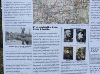
• Jour 4/9 d'une randonnée Verviers - Bretagne. Aussi souvent que possible sur petites routes et chemins. Certains pass...
![Tocht Te voet Montdidier - montdidier, la cascade court - Photo](https://media.geolcdn.com/t/350/260/ext.jpg?maxdim=2&url=https%3A%2F%2Fstatic1.geolcdn.com%2Fsiteimages%2Fupload%2Ffiles%2F1545311037marcheuse_200dpi.jpg)
![Te voet Te voet](https://static1.geolcdn.com/sitytour/trail-icons/100.png)
Km
Te voet
![](/images/other/stat-length.png)
![](https://static1.geolcdn.com/siteimages/upload/files/1508320355ic_sort_den_pos_24dp.png)
![](https://static1.geolcdn.com/siteimages/upload/files/1508320355ic_sort_den_neg_24dp.png)
![](https://static1.geolcdn.com/siteimages/upload/files/16400158638029165_repeat_loop_refresh_sync_direction_icon.png)
11 tochten weergegeven op 11
Gratisgps-wandelapplicatie