![](/images/other/stat-length.png)
Harburg, Onbekend: Top van de beste wandelroutes, trajecten, tochten en wandelingen
Harburg: Ontdek de beste tochten: 16 te voet. Al deze tochten, trajecten, routes en outdoor activiteiten zijn beschikbaar in onze SityTrail-apps voor smartphones en tablets.
De beste trajecten (16)
![Tocht Te voet Onbekend - Nordic Walking N3 Schwere Tour Heide - Photo](https://media.geolcdn.com/t/350/260/cab5b3e3-297e-4e09-9a19-234a5673b2da.jpeg&format=jpg&maxdim=2)
![Te voet Te voet](https://static1.geolcdn.com/sitytour/trail-icons/100.png)
Km
Te voet
![](/images/other/stat-length.png)
![](https://static1.geolcdn.com/siteimages/upload/files/1508320355ic_sort_den_pos_24dp.png)
![](https://static1.geolcdn.com/siteimages/upload/files/1508320355ic_sort_den_neg_24dp.png)
![](https://static1.geolcdn.com/siteimages/upload/files/16400158638029165_repeat_loop_refresh_sync_direction_icon.png)
• Ausflugsziele, Freizeit und Übernachten in der Nordheide, dem nördlichen Teil der Lüneburger Heide, verkehrsgünstig i...
![Tocht Te voet Onbekend - Nordic Walking N1 Leichte Tour Heide - Photo](https://media.geolcdn.com/t/350/260/11b8aeee-9967-427e-9069-f53f193612d3.jpeg&format=jpg&maxdim=2)
![Te voet Te voet](https://static1.geolcdn.com/sitytour/trail-icons/100.png)
Km
Te voet
![](/images/other/stat-length.png)
![](https://static1.geolcdn.com/siteimages/upload/files/1508320355ic_sort_den_pos_24dp.png)
![](https://static1.geolcdn.com/siteimages/upload/files/1508320355ic_sort_den_neg_24dp.png)
![](https://static1.geolcdn.com/siteimages/upload/files/16400158638029165_repeat_loop_refresh_sync_direction_icon.png)
• Ausflugsziele, Freizeit und Übernachten in der Nordheide, dem nördlichen Teil der Lüneburger Heide, verkehrsgünstig i...
![Tocht Te voet Onbekend - Wanderweg Nr. 26 (Finkenwerder - Neuenfelde) - Photo](https://media.geolcdn.com/t/350/260/b7c99b40-9232-4684-9c09-8f824d597f94.jpeg&format=jpg&maxdim=2)
![Te voet Te voet](https://static1.geolcdn.com/sitytour/trail-icons/100.png)
Km
Te voet
![](/images/other/stat-length.png)
![](https://static1.geolcdn.com/siteimages/upload/files/1508320355ic_sort_den_pos_24dp.png)
![](https://static1.geolcdn.com/siteimages/upload/files/1508320355ic_sort_den_neg_24dp.png)
![](https://static1.geolcdn.com/siteimages/upload/files/16400158638029165_repeat_loop_refresh_sync_direction_icon.png)
• Trail created by Wanderfreunde Hamburg e.V..
![Tocht Te voet Onbekend - Wanderweg Verbindungsweg HF-H - Photo](https://media.geolcdn.com/t/350/260/456ffa5a-8bbe-4077-905c-65704ac5cb42.jpeg&format=jpg&maxdim=2)
![Te voet Te voet](https://static1.geolcdn.com/sitytour/trail-icons/100.png)
Km
Te voet
![](/images/other/stat-length.png)
![](https://static1.geolcdn.com/siteimages/upload/files/1508320355ic_sort_den_pos_24dp.png)
![](https://static1.geolcdn.com/siteimages/upload/files/1508320355ic_sort_den_neg_24dp.png)
![](https://static1.geolcdn.com/siteimages/upload/files/16400158638029165_repeat_loop_refresh_sync_direction_icon.png)
• Trail created by Wanderverband Norddeutschland e.V.. logisch gesehen müsste es diesen Weg geben um die Verbindung zw...
![Tocht Te voet Onbekend - Wander-Tour Harburger Berge - Photo](https://media.geolcdn.com/t/350/260/69152109-3ce8-403e-943f-dd0414299b48.jpeg&format=jpg&maxdim=2)
![Te voet Te voet](https://static1.geolcdn.com/sitytour/trail-icons/100.png)
Km
Te voet
![](/images/other/stat-length.png)
![](https://static1.geolcdn.com/siteimages/upload/files/1508320355ic_sort_den_pos_24dp.png)
![](https://static1.geolcdn.com/siteimages/upload/files/1508320355ic_sort_den_neg_24dp.png)
![](https://static1.geolcdn.com/siteimages/upload/files/16400158638029165_repeat_loop_refresh_sync_direction_icon.png)
• Ausflugsziele, Freizeit und Übernachten in der Nordheide, dem nördlichen Teil der Lüneburger Heide, verkehrsgünstig i...
![Tocht Te voet Onbekend - Wanderweg KI-A - Photo](https://media.geolcdn.com/t/350/260/f4a1f4e9-fd23-4f77-a0e3-1b351d02f82e.jpeg&format=jpg&maxdim=2)
![Te voet Te voet](https://static1.geolcdn.com/sitytour/trail-icons/100.png)
Km
Te voet
![](/images/other/stat-length.png)
![](https://static1.geolcdn.com/siteimages/upload/files/1508320355ic_sort_den_pos_24dp.png)
![](https://static1.geolcdn.com/siteimages/upload/files/1508320355ic_sort_den_neg_24dp.png)
![](https://static1.geolcdn.com/siteimages/upload/files/16400158638029165_repeat_loop_refresh_sync_direction_icon.png)
• Trail created by Wanderverband Norddeutschland e.V.. Symbol: gelber Pfeil auf weissem Grund Website: http://www.wa...
![Tocht Te voet Onbekend - Wanderweg KI-N - Photo](https://media.geolcdn.com/t/350/260/dd462940-7610-414a-bb3d-dcf69eca947a.jpeg&format=jpg&maxdim=2)
![Te voet Te voet](https://static1.geolcdn.com/sitytour/trail-icons/100.png)
Km
Te voet
![](/images/other/stat-length.png)
![](https://static1.geolcdn.com/siteimages/upload/files/1508320355ic_sort_den_pos_24dp.png)
![](https://static1.geolcdn.com/siteimages/upload/files/1508320355ic_sort_den_neg_24dp.png)
![](https://static1.geolcdn.com/siteimages/upload/files/16400158638029165_repeat_loop_refresh_sync_direction_icon.png)
• Trail created by Wanderverband Norddeutschland e.V.. Symbol: gelber Pfeil auf weissem Grund Website: http://www.wa...
![Tocht Te voet Onbekend - Wanderweg KA-A - Photo](https://media.geolcdn.com/t/350/260/6754b8db-6acb-4b11-b2da-87c0475c0759.jpeg&format=jpg&maxdim=2)
![Te voet Te voet](https://static1.geolcdn.com/sitytour/trail-icons/100.png)
Km
Te voet
![](/images/other/stat-length.png)
![](https://static1.geolcdn.com/siteimages/upload/files/1508320355ic_sort_den_pos_24dp.png)
![](https://static1.geolcdn.com/siteimages/upload/files/1508320355ic_sort_den_neg_24dp.png)
![](https://static1.geolcdn.com/siteimages/upload/files/16400158638029165_repeat_loop_refresh_sync_direction_icon.png)
• Trail created by Wanderverband Norddeutschland e.V.. Symbol: gelber Pfeil auf weissem Grund Website: http://www.wa...
![Tocht Te voet Onbekend - Wanderweg HF-WFR - Photo](https://media.geolcdn.com/t/350/260/03744dda-f212-4e90-978c-ba8799e67dad.jpeg&format=jpg&maxdim=2)
![Te voet Te voet](https://static1.geolcdn.com/sitytour/trail-icons/100.png)
Km
Te voet
![](/images/other/stat-length.png)
![](https://static1.geolcdn.com/siteimages/upload/files/1508320355ic_sort_den_pos_24dp.png)
![](https://static1.geolcdn.com/siteimages/upload/files/1508320355ic_sort_den_neg_24dp.png)
![](https://static1.geolcdn.com/siteimages/upload/files/16400158638029165_repeat_loop_refresh_sync_direction_icon.png)
• Trail created by Wanderverband Norddeutschland e.V.. Symbol: gelber Pfeil auf weissem Grund Website: http://www.wa...
![Tocht Te voet Onbekend - Wanderweg HB-KI - Photo](https://media.geolcdn.com/t/350/260/96ac6397-ab6b-4cd9-9e89-9e20cfd72775.jpeg&format=jpg&maxdim=2)
![Te voet Te voet](https://static1.geolcdn.com/sitytour/trail-icons/100.png)
Km
Te voet
![](/images/other/stat-length.png)
![](https://static1.geolcdn.com/siteimages/upload/files/1508320355ic_sort_den_pos_24dp.png)
![](https://static1.geolcdn.com/siteimages/upload/files/1508320355ic_sort_den_neg_24dp.png)
![](https://static1.geolcdn.com/siteimages/upload/files/16400158638029165_repeat_loop_refresh_sync_direction_icon.png)
• Trail created by Wanderverband Norddeutschland e.V.. Symbol: gelber Pfeil auf weissem Grund Website: http://www.wa...
![Tocht Te voet Onbekend - Wanderweg 21 - Photo](https://media.geolcdn.com/t/350/260/dd462940-7610-414a-bb3d-dcf69eca947a.jpeg&format=jpg&maxdim=2)
![Te voet Te voet](https://static1.geolcdn.com/sitytour/trail-icons/100.png)
Km
Te voet
![](/images/other/stat-length.png)
![](https://static1.geolcdn.com/siteimages/upload/files/1508320355ic_sort_den_pos_24dp.png)
![](https://static1.geolcdn.com/siteimages/upload/files/1508320355ic_sort_den_neg_24dp.png)
![](https://static1.geolcdn.com/siteimages/upload/files/16400158638029165_repeat_loop_refresh_sync_direction_icon.png)
• Trail created by Wanderverband Norddeutschland e.V.. Symbol: gelber Pfeil auf weissem Grund Website: http://www.wa...
![Tocht Te voet Onbekend - Wanderweg A-H - Photo](https://media.geolcdn.com/t/350/260/f4a1f4e9-fd23-4f77-a0e3-1b351d02f82e.jpeg&format=jpg&maxdim=2)
![Te voet Te voet](https://static1.geolcdn.com/sitytour/trail-icons/100.png)
Km
Te voet
![](/images/other/stat-length.png)
![](https://static1.geolcdn.com/siteimages/upload/files/1508320355ic_sort_den_pos_24dp.png)
![](https://static1.geolcdn.com/siteimages/upload/files/1508320355ic_sort_den_neg_24dp.png)
![](https://static1.geolcdn.com/siteimages/upload/files/16400158638029165_repeat_loop_refresh_sync_direction_icon.png)
• Trail created by Wanderverband Norddeutschland e.V.. Symbol: gelber Pfeil auf weissem Grund Website: http://www.wa...
![Tocht Te voet Onbekend - Wanderweg 24 - Photo](https://media.geolcdn.com/t/350/260/03744dda-f212-4e90-978c-ba8799e67dad.jpeg&format=jpg&maxdim=2)
![Te voet Te voet](https://static1.geolcdn.com/sitytour/trail-icons/100.png)
Km
Te voet
![](/images/other/stat-length.png)
![](https://static1.geolcdn.com/siteimages/upload/files/1508320355ic_sort_den_pos_24dp.png)
![](https://static1.geolcdn.com/siteimages/upload/files/1508320355ic_sort_den_neg_24dp.png)
![](https://static1.geolcdn.com/siteimages/upload/files/16400158638029165_repeat_loop_refresh_sync_direction_icon.png)
• Trail created by Wanderverband Norddeutschland e.V.. Symbol: gelber Pfeil auf weissem Grund Website: http://www.wa...
![Tocht Te voet Onbekend - Wander-Tour Fischbeker Heide - Photo](https://media.geolcdn.com/t/350/260/11b8aeee-9967-427e-9069-f53f193612d3.jpeg&format=jpg&maxdim=2)
![Te voet Te voet](https://static1.geolcdn.com/sitytour/trail-icons/100.png)
Km
Te voet
![](/images/other/stat-length.png)
![](https://static1.geolcdn.com/siteimages/upload/files/1508320355ic_sort_den_pos_24dp.png)
![](https://static1.geolcdn.com/siteimages/upload/files/1508320355ic_sort_den_neg_24dp.png)
![](https://static1.geolcdn.com/siteimages/upload/files/16400158638029165_repeat_loop_refresh_sync_direction_icon.png)
• Ausflugsziele, Freizeit und Übernachten in der Nordheide, dem nördlichen Teil der Lüneburger Heide, verkehrsgünstig i...
![Tocht Te voet Onbekend - Wanderweg 23 - Photo](https://media.geolcdn.com/t/350/260/03744dda-f212-4e90-978c-ba8799e67dad.jpeg&format=jpg&maxdim=2)
![Te voet Te voet](https://static1.geolcdn.com/sitytour/trail-icons/100.png)
Km
Te voet
![](/images/other/stat-length.png)
![](https://static1.geolcdn.com/siteimages/upload/files/1508320355ic_sort_den_pos_24dp.png)
![](https://static1.geolcdn.com/siteimages/upload/files/1508320355ic_sort_den_neg_24dp.png)
![](https://static1.geolcdn.com/siteimages/upload/files/16400158638029165_repeat_loop_refresh_sync_direction_icon.png)
• Trail created by Wanderverband Norddeutschland e.V.. Symbol: gelber Pfeil auf weissem Grund Website: http://www.wa...
![Tocht Te voet Onbekend - Stadtscheide - Photo](https://media.geolcdn.com/t/350/260/f0e265c3-8db3-4fd9-aa11-4f9215289a1f.jpeg&format=jpg&maxdim=2)
![Te voet Te voet](https://static1.geolcdn.com/sitytour/trail-icons/100.png)
Km
Te voet
![](/images/other/stat-length.png)
![](https://static1.geolcdn.com/siteimages/upload/files/1508320355ic_sort_den_pos_24dp.png)
![](https://static1.geolcdn.com/siteimages/upload/files/1508320355ic_sort_den_neg_24dp.png)
![](https://static1.geolcdn.com/siteimages/upload/files/16400158638029165_repeat_loop_refresh_sync_direction_icon.png)
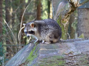
• Symbol: blaues Eichhörnchen
16 tochten weergegeven op 16
Gratisgps-wandelapplicatie