![](/images/other/stat-length.png)
Pappenheim, Landkreis Weißenburg-Gunzenhausen: Top van de beste wandelroutes, trajecten, tochten en wandelingen
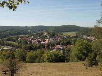
Pappenheim: Ontdek de beste tochten: 13 te voet. Al deze tochten, trajecten, routes en outdoor activiteiten zijn beschikbaar in onze SityTrail-apps voor smartphones en tablets.
De beste trajecten (13)
![Tocht Te voet Pappenheim - Ortswanderweg Pappenheim 16 - Photo](https://media.geolcdn.com/t/350/260/5e860a41-dcd4-4042-8c57-552521e854cd.jpeg&format=jpg&maxdim=2)
![Te voet Te voet](https://static1.geolcdn.com/sitytour/trail-icons/100.png)
Km
Te voet
![](/images/other/stat-length.png)
![](https://static1.geolcdn.com/siteimages/upload/files/1508320355ic_sort_den_pos_24dp.png)
![](https://static1.geolcdn.com/siteimages/upload/files/1508320355ic_sort_den_neg_24dp.png)
![](https://static1.geolcdn.com/siteimages/upload/files/16400158638029165_repeat_loop_refresh_sync_direction_icon.png)
• Trail created by Stadt Pappenheim. abgeschlossen (Juli 2014, by cycling_zno) Symbol: Grüne 16 auf gelbem Grund
![Tocht Te voet Pappenheim - Ortswanderweg Pappenheim - Photo](https://media.geolcdn.com/t/350/260/5e860a41-dcd4-4042-8c57-552521e854cd.jpeg&format=jpg&maxdim=2)
![Te voet Te voet](https://static1.geolcdn.com/sitytour/trail-icons/100.png)
Km
Te voet
![](/images/other/stat-length.png)
![](https://static1.geolcdn.com/siteimages/upload/files/1508320355ic_sort_den_pos_24dp.png)
![](https://static1.geolcdn.com/siteimages/upload/files/1508320355ic_sort_den_neg_24dp.png)
![](https://static1.geolcdn.com/siteimages/upload/files/16400158638029165_repeat_loop_refresh_sync_direction_icon.png)
• Trail created by Stadt Pappenheim. abgeschlossen (Juli 2014, by cycling_zno) Symbol: Grüne 13 auf gelbem Grund
![Tocht Te voet Pappenheim - Ortswanderweg Pappenheim 15 - Photo](https://media.geolcdn.com/t/350/260/2d5fb61c-f467-4c4a-9c97-3f43c03b5d18.jpeg&format=jpg&maxdim=2)
![Te voet Te voet](https://static1.geolcdn.com/sitytour/trail-icons/100.png)
Km
Te voet
![](/images/other/stat-length.png)
![](https://static1.geolcdn.com/siteimages/upload/files/1508320355ic_sort_den_pos_24dp.png)
![](https://static1.geolcdn.com/siteimages/upload/files/1508320355ic_sort_den_neg_24dp.png)
![](https://static1.geolcdn.com/siteimages/upload/files/16400158638029165_repeat_loop_refresh_sync_direction_icon.png)
• Trail created by Stadt Pappenheim. abgeschlossen (Mai 2014, by cycling_zno) Symbol: Grüne 15 auf gelbem Grund
![Tocht Te voet Pappenheim - Ortswanderweg Pappenheim 5 - Photo](https://media.geolcdn.com/t/350/260/5a7f43fc-96a6-46fa-b081-2d4e20939863.jpeg&format=jpg&maxdim=2)
![Te voet Te voet](https://static1.geolcdn.com/sitytour/trail-icons/100.png)
Km
Te voet
![](/images/other/stat-length.png)
![](https://static1.geolcdn.com/siteimages/upload/files/1508320355ic_sort_den_pos_24dp.png)
![](https://static1.geolcdn.com/siteimages/upload/files/1508320355ic_sort_den_neg_24dp.png)
![](https://static1.geolcdn.com/siteimages/upload/files/16400158638029165_repeat_loop_refresh_sync_direction_icon.png)
• Trail created by Stadt Pappenheim. abgeschlossen (Mai 2014, by cycling_zno) Symbol: Grüne 5 auf gelbem Grund
![Tocht Te voet Pappenheim - Ortswanderweg Pappenheim 14 - Photo](https://media.geolcdn.com/t/350/260/2d5fb61c-f467-4c4a-9c97-3f43c03b5d18.jpeg&format=jpg&maxdim=2)
![Te voet Te voet](https://static1.geolcdn.com/sitytour/trail-icons/100.png)
Km
Te voet
![](/images/other/stat-length.png)
![](https://static1.geolcdn.com/siteimages/upload/files/1508320355ic_sort_den_pos_24dp.png)
![](https://static1.geolcdn.com/siteimages/upload/files/1508320355ic_sort_den_neg_24dp.png)
![](https://static1.geolcdn.com/siteimages/upload/files/16400158638029165_repeat_loop_refresh_sync_direction_icon.png)
• Trail created by Stadt Pappenheim. abgeschlossen (Mai 2014, by cycling_zno) Symbol: Grüne 14 auf gelbem Grund
![Tocht Te voet Pappenheim - Ortswanderweg Pappenheim - Photo](https://media.geolcdn.com/t/350/260/10c3f73e-1583-4e21-96a1-b84f7b5d3f13.jpeg&format=jpg&maxdim=2)
![Te voet Te voet](https://static1.geolcdn.com/sitytour/trail-icons/100.png)
Km
Te voet
![](/images/other/stat-length.png)
![](https://static1.geolcdn.com/siteimages/upload/files/1508320355ic_sort_den_pos_24dp.png)
![](https://static1.geolcdn.com/siteimages/upload/files/1508320355ic_sort_den_neg_24dp.png)
![](https://static1.geolcdn.com/siteimages/upload/files/16400158638029165_repeat_loop_refresh_sync_direction_icon.png)
• Trail created by Stadt Pappenheim. abgeschlossen (Mai 2014, by cycling_zno) Symbol: Grüne 9 auf gelbem Grund
![Tocht Te voet Pappenheim - Ortswanderweg Pappenheim 7 - Photo](https://media.geolcdn.com/t/350/260/c9591fd3-01a2-4d8c-98bd-1445ab7a67d1.jpeg&format=jpg&maxdim=2)
![Te voet Te voet](https://static1.geolcdn.com/sitytour/trail-icons/100.png)
Km
Te voet
![](/images/other/stat-length.png)
![](https://static1.geolcdn.com/siteimages/upload/files/1508320355ic_sort_den_pos_24dp.png)
![](https://static1.geolcdn.com/siteimages/upload/files/1508320355ic_sort_den_neg_24dp.png)
![](https://static1.geolcdn.com/siteimages/upload/files/16400158638029165_repeat_loop_refresh_sync_direction_icon.png)
• Trail created by Stadt Pappenheim. abgeschlossen (Mai 2014, by cycling_zno) Symbol: Grüne 7 auf gelbem Grund
![Tocht Te voet Pappenheim - Ortswanderweg Pappenheim 2 - Photo](https://media.geolcdn.com/t/350/260/5a7f43fc-96a6-46fa-b081-2d4e20939863.jpeg&format=jpg&maxdim=2)
![Te voet Te voet](https://static1.geolcdn.com/sitytour/trail-icons/100.png)
Km
Te voet
![](/images/other/stat-length.png)
![](https://static1.geolcdn.com/siteimages/upload/files/1508320355ic_sort_den_pos_24dp.png)
![](https://static1.geolcdn.com/siteimages/upload/files/1508320355ic_sort_den_neg_24dp.png)
![](https://static1.geolcdn.com/siteimages/upload/files/16400158638029165_repeat_loop_refresh_sync_direction_icon.png)
• Trail created by Stadt Pappenheim. abgeschlossen (Mai 2014, by cycling_zno) Symbol: Grüne 2 auf gelbem Grund
![Tocht Te voet Pappenheim - Altmühltal-Rundweg - Photo](https://media.geolcdn.com/t/350/260/a87e3cb3-7153-4f66-9552-634127247d20.jpeg&format=jpg&maxdim=2)
![Te voet Te voet](https://static1.geolcdn.com/sitytour/trail-icons/100.png)
Km
Te voet
![](/images/other/stat-length.png)
![](https://static1.geolcdn.com/siteimages/upload/files/1508320355ic_sort_den_pos_24dp.png)
![](https://static1.geolcdn.com/siteimages/upload/files/1508320355ic_sort_den_neg_24dp.png)
![](https://static1.geolcdn.com/siteimages/upload/files/16400158638029165_repeat_loop_refresh_sync_direction_icon.png)
• Trail created by Gemeinde Solnhofen. abgeschlossen (Mai 2014, by cycling_zno) Symbol: Schwarze 2 auf gelbem Grund
![Tocht Te voet Pappenheim - Ortswanderweg Pappenheim 12 - Photo](https://media.geolcdn.com/t/350/260/13bf7827-2b9c-4475-bf8e-27fd4b1f7cdb.jpeg&format=jpg&maxdim=2)
![Te voet Te voet](https://static1.geolcdn.com/sitytour/trail-icons/100.png)
Km
Te voet
![](/images/other/stat-length.png)
![](https://static1.geolcdn.com/siteimages/upload/files/1508320355ic_sort_den_pos_24dp.png)
![](https://static1.geolcdn.com/siteimages/upload/files/1508320355ic_sort_den_neg_24dp.png)
![](https://static1.geolcdn.com/siteimages/upload/files/16400158638029165_repeat_loop_refresh_sync_direction_icon.png)
• Trail created by Stadt Pappenheim. abgeschlossen (Mai 2014, by cycling_zno) Symbol: Grüne 12 auf gelbem Grund
![Tocht Te voet Pappenheim - Ortswanderweg Pappenheim 18 - Photo](https://media.geolcdn.com/t/350/260/ext.jpg?maxdim=2&url=https%3A%2F%2Fstatic1.geolcdn.com%2Fsiteimages%2Fupload%2Ffiles%2F1545311037marcheuse_200dpi.jpg)
![Te voet Te voet](https://static1.geolcdn.com/sitytour/trail-icons/100.png)
Km
Te voet
![](/images/other/stat-length.png)
![](https://static1.geolcdn.com/siteimages/upload/files/1508320355ic_sort_den_pos_24dp.png)
![](https://static1.geolcdn.com/siteimages/upload/files/1508320355ic_sort_den_neg_24dp.png)
![](https://static1.geolcdn.com/siteimages/upload/files/16400158638029165_repeat_loop_refresh_sync_direction_icon.png)
• Trail created by Stadt Pappenheim. abgeschlossen (Juli 2014, by cycling_zno) Symbol: Grüne 18 auf gelbem Grund
![Tocht Te voet Pappenheim - Ortswanderweg Pappenheim 17 - Photo](https://media.geolcdn.com/t/350/260/ext.jpg?maxdim=2&url=https%3A%2F%2Fstatic1.geolcdn.com%2Fsiteimages%2Fupload%2Ffiles%2F1545311037marcheuse_200dpi.jpg)
![Te voet Te voet](https://static1.geolcdn.com/sitytour/trail-icons/100.png)
Km
Te voet
![](/images/other/stat-length.png)
![](https://static1.geolcdn.com/siteimages/upload/files/1508320355ic_sort_den_pos_24dp.png)
![](https://static1.geolcdn.com/siteimages/upload/files/1508320355ic_sort_den_neg_24dp.png)
![](https://static1.geolcdn.com/siteimages/upload/files/16400158638029165_repeat_loop_refresh_sync_direction_icon.png)
• Trail created by Stadt Pappenheim. abgeschlossen (Mai 2014, by cycling_zno) Symbol: Grüne 17 auf gelbem Grund
![Tocht Te voet Pappenheim - Ortswanderweg Pappenheim 6 - Photo](https://media.geolcdn.com/t/350/260/ext.jpg?maxdim=2&url=https%3A%2F%2Fstatic1.geolcdn.com%2Fsiteimages%2Fupload%2Ffiles%2F1545311037marcheuse_200dpi.jpg)
![Te voet Te voet](https://static1.geolcdn.com/sitytour/trail-icons/100.png)
Km
Te voet
![](/images/other/stat-length.png)
![](https://static1.geolcdn.com/siteimages/upload/files/1508320355ic_sort_den_pos_24dp.png)
![](https://static1.geolcdn.com/siteimages/upload/files/1508320355ic_sort_den_neg_24dp.png)
![](https://static1.geolcdn.com/siteimages/upload/files/16400158638029165_repeat_loop_refresh_sync_direction_icon.png)
• Trail created by Stadt Pappenheim. abgeschlossen (März 2014, by cycling_zno) Symbol: Grüne 6 auf gelbem Grund
13 tochten weergegeven op 13
Gratisgps-wandelapplicatie