![](/images/other/stat-length.png)
- Tochten
- Outdoor
- Germany
- Beieren
- Landkreis Coburg
- Seßlach
Seßlach, Landkreis Coburg: Top van de beste wandelroutes, trajecten, tochten en wandelingen
Seßlach: Ontdek de beste tochten: 5 te voet. Al deze tochten, trajecten, routes en outdoor activiteiten zijn beschikbaar in onze SityTrail-apps voor smartphones en tablets.
De beste trajecten (5)
![Tocht Te voet Seßlach - Wanderweg Gelber Balken - Photo](https://media.geolcdn.com/t/350/260/e3890aa9-56e0-4408-9489-66a2c93ad9c8.jpeg&format=jpg&maxdim=2)
![Te voet Te voet](https://static1.geolcdn.com/sitytour/trail-icons/100.png)
Km
Te voet
![](/images/other/stat-length.png)
![](https://static1.geolcdn.com/siteimages/upload/files/1508320355ic_sort_den_pos_24dp.png)
![](https://static1.geolcdn.com/siteimages/upload/files/1508320355ic_sort_den_neg_24dp.png)
![](https://static1.geolcdn.com/siteimages/upload/files/16400158638029165_repeat_loop_refresh_sync_direction_icon.png)
• Symbol: Gelber Balken auf weißem Hintergrund
![Tocht Te voet Seßlach - Rund um den Christenstein - Photo](https://media.geolcdn.com/t/350/260/6b8bf001-3dc5-405f-9d7a-c07018ca8184.jpeg&format=jpg&maxdim=2)
![Te voet Te voet](https://static1.geolcdn.com/sitytour/trail-icons/100.png)
Km
Te voet
![](/images/other/stat-length.png)
![](https://static1.geolcdn.com/siteimages/upload/files/1508320355ic_sort_den_pos_24dp.png)
![](https://static1.geolcdn.com/siteimages/upload/files/1508320355ic_sort_den_neg_24dp.png)
![](https://static1.geolcdn.com/siteimages/upload/files/16400158638029165_repeat_loop_refresh_sync_direction_icon.png)
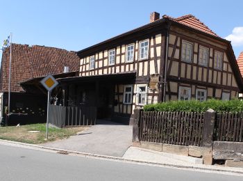
• Trail created by Stadt Seßlach. Symbol: Stilisierter gelber Torturm auf weißem Hintergrund
![Tocht Te voet Seßlach - Grenzlandweg - Photo](https://media.geolcdn.com/t/350/260/ffc2e6ac-4eec-407e-b1ba-9d1f729d5c13.jpeg&format=jpg&maxdim=2)
![Te voet Te voet](https://static1.geolcdn.com/sitytour/trail-icons/100.png)
Km
Te voet
![](/images/other/stat-length.png)
![](https://static1.geolcdn.com/siteimages/upload/files/1508320355ic_sort_den_pos_24dp.png)
![](https://static1.geolcdn.com/siteimages/upload/files/1508320355ic_sort_den_neg_24dp.png)
![](https://static1.geolcdn.com/siteimages/upload/files/16400158638029165_repeat_loop_refresh_sync_direction_icon.png)
• Trail created by Stadt Seßlach. Symbol: Stilisierter roter Torturm auf weißem Hintergrund
![Tocht Te voet Seßlach - Wanderweg Unterelldorf - Photo](https://media.geolcdn.com/t/350/260/eea554be-6d5b-4fbf-bbe0-e409c525a425.jpeg&format=jpg&maxdim=2)
![Te voet Te voet](https://static1.geolcdn.com/sitytour/trail-icons/100.png)
Km
Te voet
![](/images/other/stat-length.png)
![](https://static1.geolcdn.com/siteimages/upload/files/1508320355ic_sort_den_pos_24dp.png)
![](https://static1.geolcdn.com/siteimages/upload/files/1508320355ic_sort_den_neg_24dp.png)
![](https://static1.geolcdn.com/siteimages/upload/files/16400158638029165_repeat_loop_refresh_sync_direction_icon.png)
• unzureichende Markierung Symbol: Blaues Andreaskreuz auf weißem Hintergrund
![Tocht Te voet Seßlach - Bürgerwaldrundweg - Photo](https://media.geolcdn.com/t/350/260/0506056c-3a31-42b2-be38-c29339af82b5.jpeg&format=jpg&maxdim=2)
![Te voet Te voet](https://static1.geolcdn.com/sitytour/trail-icons/100.png)
Km
Te voet
![](/images/other/stat-length.png)
![](https://static1.geolcdn.com/siteimages/upload/files/1508320355ic_sort_den_pos_24dp.png)
![](https://static1.geolcdn.com/siteimages/upload/files/1508320355ic_sort_den_neg_24dp.png)
![](https://static1.geolcdn.com/siteimages/upload/files/16400158638029165_repeat_loop_refresh_sync_direction_icon.png)
• Trail created by Stadt Seßlach. Symbol: Stilisierter brauner Torturm auf weißem Hintergrund
5 tochten weergegeven op 5
Gratisgps-wandelapplicatie