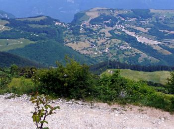
![](/images/other/stat-length.png)
Brenzone sul Garda, Verona, Te voet: Top van de beste wandelroutes, trajecten, tochten en wandelingen
Brenzone sul Garda: Ontdek de beste tochten: 7 te voet. Al deze tochten, trajecten, routes en outdoor activiteiten zijn beschikbaar in onze SityTrail-apps voor smartphones en tablets.
De beste trajecten (7)
![Tocht Te voet Brenzone sul Garda - Castelletto di Brenzone - Prada - Bocchetta di Naole - Photo](https://media.geolcdn.com/t/350/260/8b431f74-dbc1-4936-94f1-3f7a58c41920.jpeg&format=jpg&maxdim=2)
![Te voet Te voet](https://static1.geolcdn.com/sitytour/trail-icons/100.png)
Km
Te voet
![](/images/other/stat-length.png)
![](https://static1.geolcdn.com/siteimages/upload/files/1508320355ic_sort_den_pos_24dp.png)
![](https://static1.geolcdn.com/siteimages/upload/files/1508320355ic_sort_den_neg_24dp.png)
![](https://static1.geolcdn.com/siteimages/upload/files/16400158638029165_repeat_loop_refresh_sync_direction_icon.png)
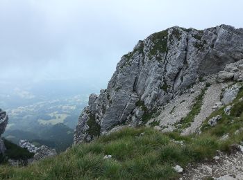
• Trail created by Club Alpino Italiano. Symbol: 655 on white red flag
![Tocht Te voet Brenzone sul Garda - Castelletto di Brenzone - Prada - Photo](https://media.geolcdn.com/t/350/260/f2f604a5-834c-4ba2-88b8-da60121650ff.jpeg&format=jpg&maxdim=2)
![Te voet Te voet](https://static1.geolcdn.com/sitytour/trail-icons/100.png)
Km
Te voet
![](/images/other/stat-length.png)
![](https://static1.geolcdn.com/siteimages/upload/files/1508320355ic_sort_den_pos_24dp.png)
![](https://static1.geolcdn.com/siteimages/upload/files/1508320355ic_sort_den_neg_24dp.png)
![](https://static1.geolcdn.com/siteimages/upload/files/16400158638029165_repeat_loop_refresh_sync_direction_icon.png)
• Trail created by Club Alpino Italiano Sezione Cesare Battisti di Verona. Symbol: 655 on white red flag
![Tocht Te voet Brenzone sul Garda - Percorsi tra il bosco e gli ulivi - Photo](https://media.geolcdn.com/t/350/260/5b4d10a5-709f-4da0-99d7-13f49baaf5e2.jpeg&format=jpg&maxdim=2)
![Te voet Te voet](https://static1.geolcdn.com/sitytour/trail-icons/100.png)
Km
Te voet
![](/images/other/stat-length.png)
![](https://static1.geolcdn.com/siteimages/upload/files/1508320355ic_sort_den_pos_24dp.png)
![](https://static1.geolcdn.com/siteimages/upload/files/1508320355ic_sort_den_neg_24dp.png)
![](https://static1.geolcdn.com/siteimages/upload/files/16400158638029165_repeat_loop_refresh_sync_direction_icon.png)
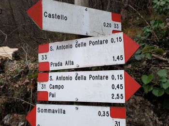
• Scopri gli itinerari del Nordic Walking Park, Le Vie dei Monti e Sentiero Natura di Sommavilla. Regalatevi una indime...
![Tocht Te voet Brenzone sul Garda - Assenza - Rifugio Telegrafo - Photo](https://media.geolcdn.com/t/350/260/7182009a-9f8e-49c3-b9e9-e7b41654bdcb.jpeg&format=jpg&maxdim=2)
![Te voet Te voet](https://static1.geolcdn.com/sitytour/trail-icons/100.png)
Km
Te voet
![](/images/other/stat-length.png)
![](https://static1.geolcdn.com/siteimages/upload/files/1508320355ic_sort_den_pos_24dp.png)
![](https://static1.geolcdn.com/siteimages/upload/files/1508320355ic_sort_den_neg_24dp.png)
![](https://static1.geolcdn.com/siteimages/upload/files/16400158638029165_repeat_loop_refresh_sync_direction_icon.png)
• Trail created by Club Alpino Italiano Sezione Cesare Battisti di Verona. Symbol: 654 on white red flag
![Tocht Te voet Brenzone sul Garda - Bocchetta di Naole - Rifugio Gaetano Barana al Telegrafo - Photo](https://media.geolcdn.com/t/350/260/c620b252-07c8-4a30-81a6-ac01b8f00d63.jpeg&format=jpg&maxdim=2)
![Te voet Te voet](https://static1.geolcdn.com/sitytour/trail-icons/100.png)
Km
Te voet
![](/images/other/stat-length.png)
![](https://static1.geolcdn.com/siteimages/upload/files/1508320355ic_sort_den_pos_24dp.png)
![](https://static1.geolcdn.com/siteimages/upload/files/1508320355ic_sort_den_neg_24dp.png)
![](https://static1.geolcdn.com/siteimages/upload/files/16400158638029165_repeat_loop_refresh_sync_direction_icon.png)
• Trail created by Club Alpino Italiano Sezione di Verona. Symbol: 658 on white red flag
![Tocht Te voet Brenzone sul Garda - Marniga - Prada Alta - Photo](https://media.geolcdn.com/t/350/260/82eb7f9a-8c22-44d6-bd47-84c77b73c9db.jpeg&format=jpg&maxdim=2)
![Te voet Te voet](https://static1.geolcdn.com/sitytour/trail-icons/100.png)
Km
Te voet
![](/images/other/stat-length.png)
![](https://static1.geolcdn.com/siteimages/upload/files/1508320355ic_sort_den_pos_24dp.png)
![](https://static1.geolcdn.com/siteimages/upload/files/1508320355ic_sort_den_neg_24dp.png)
![](https://static1.geolcdn.com/siteimages/upload/files/16400158638029165_repeat_loop_refresh_sync_direction_icon.png)
• Trail created by Club Alpino Italiano Sezione Cesare Battisti di Verona. relation mantained by Club Alpino Italiano ...
![Tocht Te voet Brenzone sul Garda - Castello di Brenzone - Prada Alta - Photo](https://media.geolcdn.com/t/350/260/460ee216-ecf6-459a-af8a-aa25c95a0718.jpeg&format=jpg&maxdim=2)
![Te voet Te voet](https://static1.geolcdn.com/sitytour/trail-icons/100.png)
Km
Te voet
![](/images/other/stat-length.png)
![](https://static1.geolcdn.com/siteimages/upload/files/1508320355ic_sort_den_pos_24dp.png)
![](https://static1.geolcdn.com/siteimages/upload/files/1508320355ic_sort_den_neg_24dp.png)
![](https://static1.geolcdn.com/siteimages/upload/files/16400158638029165_repeat_loop_refresh_sync_direction_icon.png)
• Trail created by Club Alpino Italiano Sezione Cesare Battisti di Verona. relation mantained by Club Alpino Italiano ...
7 tochten weergegeven op 7
Gratisgps-wandelapplicatie