


12,6 km | 21 km-effort
Corniglio: Ontdek de beste tochten: 12 te voet en 1 stappen. Al deze tochten, trajecten, routes en outdoor activiteiten zijn beschikbaar in onze SityTrail-apps voor smartphones en tablets.
Te voet


• relation maintained by Capataz (CAI Parma) Symbol: 743 on white red flags
Te voet
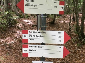
• Trail created by Club Alpino Italiano - sezione di Parma. relation maintained by Capataz (CAI Parma) Symbol: 711 on...
Te voet
• Sentiero Italia CAI 2019
Te voet
• Trail created by CAI Filattiera.
Te voet
• relation maintained by Capataz (CAI Parma) Symbol: 741 on white red flags
Te voet
• Trail created by CAI Filattiera.
Te voet
• Trail created by Club Alpino Italiano - sezione di Parma. relation maintained by Capataz (CAI Parma) Symbol: 719 on...
Te voet
• Trail created by Club Alpino Italiano - sezione di Parma. relation maintained by Capataz (CAI Parma) Symbol: 721 on...
Te voet
• Trail created by Club Alpino Italiano - sezione di Parma. relation maintained by Capataz (CAI Parma) Symbol: 725 on...
Te voet
• Trail created by Club Alpino Italiano - sezione di Parma. relation maintained by Capataz (CAI Parma) Symbol: 723 on...

Te voet
• Trail created by Parchi del Ducato. relation maintained by Capataz (CAI Parma) Symbol: 737A on white red flags
Te voet
• Trail created by Club Alpino Italiano - sezione di Parma. relation maintained by Capataz (CAI Parma) Symbol: 739 on...

Stappen
13 tochten weergegeven op 13
Gratisgps-wandelapplicatie
 SityTrail
IGN / Geografische instituten
SityTrail World
De wereld gaat voor u open