![](/images/other/stat-length.png)
Landkreis Hersfeld-Rotenburg, Hessen, Te voet: Top van de beste wandelroutes, trajecten, tochten en wandelingen
Landkreis Hersfeld-Rotenburg: Ontdek de beste tochten: 72 te voet. Al deze tochten, trajecten, routes en outdoor activiteiten zijn beschikbaar in onze SityTrail-apps voor smartphones en tablets.
De beste trajecten (72)
![Tocht Te voet Haunetal - Turmweg - Kurzvariante - Photo](https://media.geolcdn.com/t/350/260/570c5804-2c02-4f4f-b6e0-2405b75b7cad.jpeg&format=jpg&maxdim=2)
![Te voet Te voet](https://static1.geolcdn.com/sitytour/trail-icons/100.png)
Km
Te voet
![](/images/other/stat-length.png)
![](https://static1.geolcdn.com/siteimages/upload/files/1508320355ic_sort_den_pos_24dp.png)
![](https://static1.geolcdn.com/siteimages/upload/files/1508320355ic_sort_den_neg_24dp.png)
![](https://static1.geolcdn.com/siteimages/upload/files/16400158638029165_repeat_loop_refresh_sync_direction_icon.png)
• Trail created by Heimat- und Verkehrsverein Haunetal. Symbol: weißes Schild mit Text "Turmweg" Website: https://ww...
![Tocht Te voet Rotenburg an der Fulda - Heienbach-Tour - Photo](https://media.geolcdn.com/t/350/260/68477b14-fe23-47de-9435-6f88bc7fbc30.jpeg&format=jpg&maxdim=2)
![Te voet Te voet](https://static1.geolcdn.com/sitytour/trail-icons/100.png)
Km
Te voet
![](/images/other/stat-length.png)
![](https://static1.geolcdn.com/siteimages/upload/files/1508320355ic_sort_den_pos_24dp.png)
![](https://static1.geolcdn.com/siteimages/upload/files/1508320355ic_sort_den_neg_24dp.png)
![](https://static1.geolcdn.com/siteimages/upload/files/16400158638029165_repeat_loop_refresh_sync_direction_icon.png)
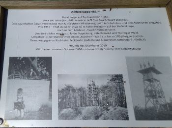
• Trail created by Rotenburg. Symbol: blaues W und schwarze 5 auf gelbem Grund
![Tocht Te voet Rotenburg an der Fulda - Rotenburg Wanderweg R3 - Photo](https://media.geolcdn.com/t/350/260/bf2c482b-fc47-4c45-b5dc-933ad3a0d025.jpeg&format=jpg&maxdim=2)
![Te voet Te voet](https://static1.geolcdn.com/sitytour/trail-icons/100.png)
Km
Te voet
![](/images/other/stat-length.png)
![](https://static1.geolcdn.com/siteimages/upload/files/1508320355ic_sort_den_pos_24dp.png)
![](https://static1.geolcdn.com/siteimages/upload/files/1508320355ic_sort_den_neg_24dp.png)
![](https://static1.geolcdn.com/siteimages/upload/files/16400158638029165_repeat_loop_refresh_sync_direction_icon.png)
• Trail created by Rotenburg a.d. Fulda. Symbol: schwarzer Text R3 auf gelbem Grund
![Tocht Te voet Rotenburg an der Fulda - Rotenburg Wanderweg R2 - Photo](https://media.geolcdn.com/t/350/260/ed5ee080-03e4-406d-b675-6e7dafc277ac.jpeg&format=jpg&maxdim=2)
![Te voet Te voet](https://static1.geolcdn.com/sitytour/trail-icons/100.png)
Km
Te voet
![](/images/other/stat-length.png)
![](https://static1.geolcdn.com/siteimages/upload/files/1508320355ic_sort_den_pos_24dp.png)
![](https://static1.geolcdn.com/siteimages/upload/files/1508320355ic_sort_den_neg_24dp.png)
![](https://static1.geolcdn.com/siteimages/upload/files/16400158638029165_repeat_loop_refresh_sync_direction_icon.png)
• Trail created by Rotenburg an der Fulda. Symbol: schwarzer Text R2 auf gelbem Grund
![Tocht Te voet Rotenburg an der Fulda - Rotenburg Wanderweg R1 - Photo](https://media.geolcdn.com/t/350/260/1b095363-56d5-4f85-a348-d07d4ce97920.jpeg&format=jpg&maxdim=2)
![Te voet Te voet](https://static1.geolcdn.com/sitytour/trail-icons/100.png)
Km
Te voet
![](/images/other/stat-length.png)
![](https://static1.geolcdn.com/siteimages/upload/files/1508320355ic_sort_den_pos_24dp.png)
![](https://static1.geolcdn.com/siteimages/upload/files/1508320355ic_sort_den_neg_24dp.png)
![](https://static1.geolcdn.com/siteimages/upload/files/16400158638029165_repeat_loop_refresh_sync_direction_icon.png)
• Trail created by Rotenburg an der Fulda. Symbol: schwarzer Text R1 auf gelbem Grund
![Tocht Te voet Alheim - Niedergude Rundweg N5 - Photo](https://media.geolcdn.com/t/350/260/76bc2c08-a47e-439f-ba1c-f03ce7c5abbb.jpeg&format=jpg&maxdim=2)
![Te voet Te voet](https://static1.geolcdn.com/sitytour/trail-icons/100.png)
Km
Te voet
![](/images/other/stat-length.png)
![](https://static1.geolcdn.com/siteimages/upload/files/1508320355ic_sort_den_pos_24dp.png)
![](https://static1.geolcdn.com/siteimages/upload/files/1508320355ic_sort_den_neg_24dp.png)
![](https://static1.geolcdn.com/siteimages/upload/files/16400158638029165_repeat_loop_refresh_sync_direction_icon.png)
• Symbol: gelber Text N5 auf grünem Grund
![Tocht Te voet Breitenbach am Herzberg - B4 - Photo](https://media.geolcdn.com/t/350/260/f7a56115-464e-4405-9789-c7734cd33733.jpeg&format=jpg&maxdim=2)
![Te voet Te voet](https://static1.geolcdn.com/sitytour/trail-icons/100.png)
Km
Te voet
![](/images/other/stat-length.png)
![](https://static1.geolcdn.com/siteimages/upload/files/1508320355ic_sort_den_pos_24dp.png)
![](https://static1.geolcdn.com/siteimages/upload/files/1508320355ic_sort_den_neg_24dp.png)
![](https://static1.geolcdn.com/siteimages/upload/files/16400158638029165_repeat_loop_refresh_sync_direction_icon.png)
• Trail created by Knüllgebirgsverein. incomplete
![Tocht Te voet Nentershausen - Premiumweg P18 Tannenburg - Photo](https://media.geolcdn.com/t/350/260/d6e4be31-f4af-4bc1-86e9-43283d2db162.jpeg&format=jpg&maxdim=2)
![Te voet Te voet](https://static1.geolcdn.com/sitytour/trail-icons/100.png)
Km
Te voet
![](/images/other/stat-length.png)
![](https://static1.geolcdn.com/siteimages/upload/files/1508320355ic_sort_den_pos_24dp.png)
![](https://static1.geolcdn.com/siteimages/upload/files/1508320355ic_sort_den_neg_24dp.png)
![](https://static1.geolcdn.com/siteimages/upload/files/16400158638029165_repeat_loop_refresh_sync_direction_icon.png)
• Trail created by Naturpark Meißner. Symbol: gelber Text P18 in gelbem Kreis
![Tocht Te voet Neuenstein - Wanderweg Neuenstein (N1) - Photo](https://media.geolcdn.com/t/350/260/b1e7534e-2cb2-4c2f-8428-d94f4328b0d0.jpeg&format=jpg&maxdim=2)
![Te voet Te voet](https://static1.geolcdn.com/sitytour/trail-icons/100.png)
Km
Te voet
![](/images/other/stat-length.png)
![](https://static1.geolcdn.com/siteimages/upload/files/1508320355ic_sort_den_pos_24dp.png)
![](https://static1.geolcdn.com/siteimages/upload/files/1508320355ic_sort_den_neg_24dp.png)
![](https://static1.geolcdn.com/siteimages/upload/files/16400158638029165_repeat_loop_refresh_sync_direction_icon.png)
• Symbol: N1 yellow on green
![Tocht Te voet Neuenstein - Obergeiser Rundweg 4 - Photo](https://media.geolcdn.com/t/350/260/9700b78a-f42d-45de-bfbd-980db133d340.jpeg&format=jpg&maxdim=2)
![Te voet Te voet](https://static1.geolcdn.com/sitytour/trail-icons/100.png)
Km
Te voet
![](/images/other/stat-length.png)
![](https://static1.geolcdn.com/siteimages/upload/files/1508320355ic_sort_den_pos_24dp.png)
![](https://static1.geolcdn.com/siteimages/upload/files/1508320355ic_sort_den_neg_24dp.png)
![](https://static1.geolcdn.com/siteimages/upload/files/16400158638029165_repeat_loop_refresh_sync_direction_icon.png)
• Symbol: O4 yellow on black
![Tocht Te voet Neuenstein - Eisenberg-Siegelweg - Photo](https://media.geolcdn.com/t/350/260/2cf05c04-ea53-419d-a197-6d647fe4e63f.jpeg&format=jpg&maxdim=2)
![Te voet Te voet](https://static1.geolcdn.com/sitytour/trail-icons/100.png)
Km
Te voet
![](/images/other/stat-length.png)
![](https://static1.geolcdn.com/siteimages/upload/files/1508320355ic_sort_den_pos_24dp.png)
![](https://static1.geolcdn.com/siteimages/upload/files/1508320355ic_sort_den_neg_24dp.png)
![](https://static1.geolcdn.com/siteimages/upload/files/16400158638029165_repeat_loop_refresh_sync_direction_icon.png)
• complete Symbol: ES yellow on green
![Tocht Te voet Kirchheim - Eisenbergweg (+42) - Photo](https://media.geolcdn.com/t/350/260/cd95029a-a763-42dd-b746-cfc0d7ccc62b.jpeg&format=jpg&maxdim=2)
![Te voet Te voet](https://static1.geolcdn.com/sitytour/trail-icons/100.png)
Km
Te voet
![](/images/other/stat-length.png)
![](https://static1.geolcdn.com/siteimages/upload/files/1508320355ic_sort_den_pos_24dp.png)
![](https://static1.geolcdn.com/siteimages/upload/files/1508320355ic_sort_den_neg_24dp.png)
![](https://static1.geolcdn.com/siteimages/upload/files/16400158638029165_repeat_loop_refresh_sync_direction_icon.png)
• Trail created by Knüllgebirgsverein. Symbol: +42 white on black
![Tocht Te voet Niederaula - Herzberg Höhenweg - Photo](https://media.geolcdn.com/t/350/260/778bf8af-3a9a-4e9b-bb67-a82d9010de7d.jpeg&format=jpg&maxdim=2)
![Te voet Te voet](https://static1.geolcdn.com/sitytour/trail-icons/100.png)
Km
Te voet
![](/images/other/stat-length.png)
![](https://static1.geolcdn.com/siteimages/upload/files/1508320355ic_sort_den_pos_24dp.png)
![](https://static1.geolcdn.com/siteimages/upload/files/1508320355ic_sort_den_neg_24dp.png)
![](https://static1.geolcdn.com/siteimages/upload/files/16400158638029165_repeat_loop_refresh_sync_direction_icon.png)
• Trail created by Knüllgebirgsverein. incomplete Symbol: white _less than_ with 45 on black
![Tocht Te voet Rotenburg an der Fulda - Braach Rundweg B5 - Photo](https://media.geolcdn.com/t/350/260/90a01be5-a2e5-4513-a094-183054857e81.jpeg&format=jpg&maxdim=2)
![Te voet Te voet](https://static1.geolcdn.com/sitytour/trail-icons/100.png)
Km
Te voet
![](/images/other/stat-length.png)
![](https://static1.geolcdn.com/siteimages/upload/files/1508320355ic_sort_den_pos_24dp.png)
![](https://static1.geolcdn.com/siteimages/upload/files/1508320355ic_sort_den_neg_24dp.png)
![](https://static1.geolcdn.com/siteimages/upload/files/16400158638029165_repeat_loop_refresh_sync_direction_icon.png)
• Symbol: schwarzer Text B5 auf gelbem Grund
![Tocht Te voet Rotenburg an der Fulda - Braach Rundweg B1 - Photo](https://media.geolcdn.com/t/350/260/90a01be5-a2e5-4513-a094-183054857e81.jpeg&format=jpg&maxdim=2)
![Te voet Te voet](https://static1.geolcdn.com/sitytour/trail-icons/100.png)
Km
Te voet
![](/images/other/stat-length.png)
![](https://static1.geolcdn.com/siteimages/upload/files/1508320355ic_sort_den_pos_24dp.png)
![](https://static1.geolcdn.com/siteimages/upload/files/1508320355ic_sort_den_neg_24dp.png)
![](https://static1.geolcdn.com/siteimages/upload/files/16400158638029165_repeat_loop_refresh_sync_direction_icon.png)
• Symbol: schwarzer Text B1 auf gelbem Grund
![Tocht Te voet Rotenburg an der Fulda - Rotenburg-Cornberg - Photo](https://media.geolcdn.com/t/350/260/f84ca8f5-c4d9-4125-8f34-bd1fd1873f6d.jpeg&format=jpg&maxdim=2)
![Te voet Te voet](https://static1.geolcdn.com/sitytour/trail-icons/100.png)
Km
Te voet
![](/images/other/stat-length.png)
![](https://static1.geolcdn.com/siteimages/upload/files/1508320355ic_sort_den_pos_24dp.png)
![](https://static1.geolcdn.com/siteimages/upload/files/1508320355ic_sort_den_neg_24dp.png)
![](https://static1.geolcdn.com/siteimages/upload/files/16400158638029165_repeat_loop_refresh_sync_direction_icon.png)
• Trail created by Hessisch-Waldeckischer Gebirgs- und Heimatverein. Symbol: weißes Dach
![Tocht Te voet Bad Hersfeld - Stellerskuppenweg - Photo](https://media.geolcdn.com/t/350/260/a3be0fa8-5cee-4210-b664-87b0a5ea5ec5.jpeg&format=jpg&maxdim=2)
![Te voet Te voet](https://static1.geolcdn.com/sitytour/trail-icons/100.png)
Km
Te voet
![](/images/other/stat-length.png)
![](https://static1.geolcdn.com/siteimages/upload/files/1508320355ic_sort_den_pos_24dp.png)
![](https://static1.geolcdn.com/siteimages/upload/files/1508320355ic_sort_den_neg_24dp.png)
![](https://static1.geolcdn.com/siteimages/upload/files/16400158638029165_repeat_loop_refresh_sync_direction_icon.png)
• Trail created by Knüllgebirgsverein. incomplete Symbol: white _less than_ with 18 on black
![Tocht Te voet Wildeck - Rhäden-Rundweg - Photo](https://media.geolcdn.com/t/350/260/918e8bb8-e00f-457f-a945-b861948ac60a.jpeg&format=jpg&maxdim=2)
![Te voet Te voet](https://static1.geolcdn.com/sitytour/trail-icons/100.png)
Km
Te voet
![](/images/other/stat-length.png)
![](https://static1.geolcdn.com/siteimages/upload/files/1508320355ic_sort_den_pos_24dp.png)
![](https://static1.geolcdn.com/siteimages/upload/files/1508320355ic_sort_den_neg_24dp.png)
![](https://static1.geolcdn.com/siteimages/upload/files/16400158638029165_repeat_loop_refresh_sync_direction_icon.png)
![Tocht Te voet Bad Hersfeld - Lange Heide 3 - Photo](https://media.geolcdn.com/t/350/260/540ab7b2-956b-4d06-9d59-2bf75bb9376e.jpeg&format=jpg&maxdim=2)
![Te voet Te voet](https://static1.geolcdn.com/sitytour/trail-icons/100.png)
Km
Te voet
![](/images/other/stat-length.png)
![](https://static1.geolcdn.com/siteimages/upload/files/1508320355ic_sort_den_pos_24dp.png)
![](https://static1.geolcdn.com/siteimages/upload/files/1508320355ic_sort_den_neg_24dp.png)
![](https://static1.geolcdn.com/siteimages/upload/files/16400158638029165_repeat_loop_refresh_sync_direction_icon.png)
• Symbol: grüne 3 in grünem Kreis auf schwarzem Grund
![Tocht Te voet Alheim - Braach Rundweg B2 - Photo](https://media.geolcdn.com/t/350/260/90a01be5-a2e5-4513-a094-183054857e81.jpeg&format=jpg&maxdim=2)
![Te voet Te voet](https://static1.geolcdn.com/sitytour/trail-icons/100.png)
Km
Te voet
![](/images/other/stat-length.png)
![](https://static1.geolcdn.com/siteimages/upload/files/1508320355ic_sort_den_pos_24dp.png)
![](https://static1.geolcdn.com/siteimages/upload/files/1508320355ic_sort_den_neg_24dp.png)
![](https://static1.geolcdn.com/siteimages/upload/files/16400158638029165_repeat_loop_refresh_sync_direction_icon.png)
• Symbol: schwarzer Text B2 auf gelbem Grund
20 tochten weergegeven op 72
Gratisgps-wandelapplicatie