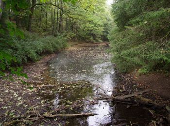
![](/images/other/stat-length.png)
- Tochten
- Te voet
- Germany
- Noordrijn-Westfalen
- Kreis Gütersloh
- Schloß Holte-Stukenbrock
Schloß Holte-Stukenbrock, Kreis Gütersloh, Te voet: Top van de beste wandelroutes, trajecten, tochten en wandelingen
Schloß Holte-Stukenbrock: Ontdek de beste tochten: 6 te voet. Al deze tochten, trajecten, routes en outdoor activiteiten zijn beschikbaar in onze SityTrail-apps voor smartphones en tablets.
De beste trajecten (6)
![Tocht Te voet Schloß Holte-Stukenbrock - Romantisches Furlbachtal - Photo](https://media.geolcdn.com/t/350/260/3b4c90b3-ac39-47a8-a47a-b37ecca07826.jpeg&format=jpg&maxdim=2)
![Te voet Te voet](https://static1.geolcdn.com/sitytour/trail-icons/100.png)
Km
Te voet
![](/images/other/stat-length.png)
![](https://static1.geolcdn.com/siteimages/upload/files/1508320355ic_sort_den_pos_24dp.png)
![](https://static1.geolcdn.com/siteimages/upload/files/1508320355ic_sort_den_neg_24dp.png)
![](https://static1.geolcdn.com/siteimages/upload/files/16400158638029165_repeat_loop_refresh_sync_direction_icon.png)
• Trail created by Stadt Schloß Holte-Stukenbrock. Symbol: Weißer Eisvogel auf blauem Grund
![Tocht Te voet Schloß Holte-Stukenbrock - Rundwanderweg A9 - Photo](https://media.geolcdn.com/t/350/260/578e171c-e1ff-4b2e-be2f-4ce980f02eb0.jpeg&format=jpg&maxdim=2)
![Te voet Te voet](https://static1.geolcdn.com/sitytour/trail-icons/100.png)
Km
Te voet
![](/images/other/stat-length.png)
![](https://static1.geolcdn.com/siteimages/upload/files/1508320355ic_sort_den_pos_24dp.png)
![](https://static1.geolcdn.com/siteimages/upload/files/1508320355ic_sort_den_neg_24dp.png)
![](https://static1.geolcdn.com/siteimages/upload/files/16400158638029165_repeat_loop_refresh_sync_direction_icon.png)
• Trail created by Heimat- und Verkehrsverein Schloß Holte-Stukenbrock. Symbol: Weißer Text 'A9' auf schwarzem Grund
![Tocht Te voet Schloß Holte-Stukenbrock - Rundwanderweg A8 - Photo](https://media.geolcdn.com/t/350/260/578e171c-e1ff-4b2e-be2f-4ce980f02eb0.jpeg&format=jpg&maxdim=2)
![Te voet Te voet](https://static1.geolcdn.com/sitytour/trail-icons/100.png)
Km
Te voet
![](/images/other/stat-length.png)
![](https://static1.geolcdn.com/siteimages/upload/files/1508320355ic_sort_den_pos_24dp.png)
![](https://static1.geolcdn.com/siteimages/upload/files/1508320355ic_sort_den_neg_24dp.png)
![](https://static1.geolcdn.com/siteimages/upload/files/16400158638029165_repeat_loop_refresh_sync_direction_icon.png)
• Trail created by Heimat- und Verkehrsverein Schloß Holte-Stukenbrock. Symbol: Weißer Text 'A8' auf schwarzem Grund
![Tocht Te voet Schloß Holte-Stukenbrock - Rundwanderweg A7 - Photo](https://media.geolcdn.com/t/350/260/578e171c-e1ff-4b2e-be2f-4ce980f02eb0.jpeg&format=jpg&maxdim=2)
![Te voet Te voet](https://static1.geolcdn.com/sitytour/trail-icons/100.png)
Km
Te voet
![](/images/other/stat-length.png)
![](https://static1.geolcdn.com/siteimages/upload/files/1508320355ic_sort_den_pos_24dp.png)
![](https://static1.geolcdn.com/siteimages/upload/files/1508320355ic_sort_den_neg_24dp.png)
![](https://static1.geolcdn.com/siteimages/upload/files/16400158638029165_repeat_loop_refresh_sync_direction_icon.png)
• Trail created by Heimat- und Verkehrsverein Schloß Holte-Stukenbrock. Symbol: Weißer Text 'A7' auf schwarzem Grund
![Tocht Te voet Schloß Holte-Stukenbrock - Rundwanderweg A6 - Photo](https://media.geolcdn.com/t/350/260/578e171c-e1ff-4b2e-be2f-4ce980f02eb0.jpeg&format=jpg&maxdim=2)
![Te voet Te voet](https://static1.geolcdn.com/sitytour/trail-icons/100.png)
Km
Te voet
![](/images/other/stat-length.png)
![](https://static1.geolcdn.com/siteimages/upload/files/1508320355ic_sort_den_pos_24dp.png)
![](https://static1.geolcdn.com/siteimages/upload/files/1508320355ic_sort_den_neg_24dp.png)
![](https://static1.geolcdn.com/siteimages/upload/files/16400158638029165_repeat_loop_refresh_sync_direction_icon.png)
• Trail created by Heimat- und Verkehrsverein Schloß Holte-Stukenbrock. Symbol: Weißer Text 'A6' auf schwarzem Grund
![Tocht Te voet Schloß Holte-Stukenbrock - Sennebahn-Wanderweg - Photo](https://media.geolcdn.com/t/350/260/93194629-04fc-4922-a21d-074c55308d36.jpeg&format=jpg&maxdim=2)
![Te voet Te voet](https://static1.geolcdn.com/sitytour/trail-icons/100.png)
Km
Te voet
![](/images/other/stat-length.png)
![](https://static1.geolcdn.com/siteimages/upload/files/1508320355ic_sort_den_pos_24dp.png)
![](https://static1.geolcdn.com/siteimages/upload/files/1508320355ic_sort_den_neg_24dp.png)
![](https://static1.geolcdn.com/siteimages/upload/files/16400158638029165_repeat_loop_refresh_sync_direction_icon.png)
• Trail created by Eggegebirgsverein. Symbol: small coloured 3D locomotive
6 tochten weergegeven op 6
Gratisgps-wandelapplicatie