![](/images/other/stat-length.png)
- Tochten
- Te voet
- Switzerland
- Luzern
- Onbekend
- Beromünster
Beromünster, Onbekend, Te voet: Top van de beste wandelroutes, trajecten, tochten en wandelingen
Beromünster: Ontdek de beste tochten: 7 te voet. Al deze tochten, trajecten, routes en outdoor activiteiten zijn beschikbaar in onze SityTrail-apps voor smartphones en tablets.
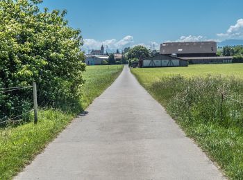
De beste trajecten (7)
![Tocht Te voet Beromünster - Neudorf - Unter Blosenberg - Photo](https://media.geolcdn.com/t/350/260/a9e8306d-f111-4dfc-9c67-cc4e4df5163f.jpeg&format=jpg&maxdim=2)
![Te voet Te voet](https://static1.geolcdn.com/sitytour/trail-icons/100.png)
Km
Te voet
![](/images/other/stat-length.png)
![](https://static1.geolcdn.com/siteimages/upload/files/1508320355ic_sort_den_pos_24dp.png)
![](https://static1.geolcdn.com/siteimages/upload/files/1508320355ic_sort_den_neg_24dp.png)
![](https://static1.geolcdn.com/siteimages/upload/files/16400158638029165_repeat_loop_refresh_sync_direction_icon.png)
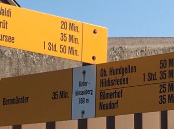
• Trail created by Luzerner Wanderwege. Symbol: gelber Rhombus
![Tocht Te voet Beromünster - Schwarzenbach - Beromünster - Photo](https://media.geolcdn.com/t/350/260/e88d537e-aca9-4ebf-bce9-a8c4e3ef5056.jpeg&format=jpg&maxdim=2)
![Te voet Te voet](https://static1.geolcdn.com/sitytour/trail-icons/100.png)
Km
Te voet
![](/images/other/stat-length.png)
![](https://static1.geolcdn.com/siteimages/upload/files/1508320355ic_sort_den_pos_24dp.png)
![](https://static1.geolcdn.com/siteimages/upload/files/1508320355ic_sort_den_neg_24dp.png)
![](https://static1.geolcdn.com/siteimages/upload/files/16400158638029165_repeat_loop_refresh_sync_direction_icon.png)
• Schwarzenbach - Beromünster Symbol: gelber Diamant
![Tocht Te voet Beromünster - Morentaler Wald - Blosenberg - Photo](https://media.geolcdn.com/t/350/260/a9e8306d-f111-4dfc-9c67-cc4e4df5163f.jpeg&format=jpg&maxdim=2)
![Te voet Te voet](https://static1.geolcdn.com/sitytour/trail-icons/100.png)
Km
Te voet
![](/images/other/stat-length.png)
![](https://static1.geolcdn.com/siteimages/upload/files/1508320355ic_sort_den_pos_24dp.png)
![](https://static1.geolcdn.com/siteimages/upload/files/1508320355ic_sort_den_neg_24dp.png)
![](https://static1.geolcdn.com/siteimages/upload/files/16400158638029165_repeat_loop_refresh_sync_direction_icon.png)
• Trail created by Luzerner Wanderwege. Morentaler Wald - Blosenberg Symbol: gelber Rhombus
![Tocht Te voet Beromünster - Waldhaus - Älmeringen -Gormund - Photo](https://media.geolcdn.com/t/350/260/c9cebd51-7d26-4f59-8a42-112d0a21e44a.jpeg&format=jpg&maxdim=2)
![Te voet Te voet](https://static1.geolcdn.com/sitytour/trail-icons/100.png)
Km
Te voet
![](/images/other/stat-length.png)
![](https://static1.geolcdn.com/siteimages/upload/files/1508320355ic_sort_den_pos_24dp.png)
![](https://static1.geolcdn.com/siteimages/upload/files/1508320355ic_sort_den_neg_24dp.png)
![](https://static1.geolcdn.com/siteimages/upload/files/16400158638029165_repeat_loop_refresh_sync_direction_icon.png)
• Waldhaus - Älmeringen -Gormund Symbol: gelber Diamant
![Tocht Te voet Beromünster - Neudorf - Beromünster - Photo](https://media.geolcdn.com/t/350/260/024eed18-2ccb-46fe-8771-53f1d14110fe.jpeg&format=jpg&maxdim=2)
![Te voet Te voet](https://static1.geolcdn.com/sitytour/trail-icons/100.png)
Km
Te voet
![](/images/other/stat-length.png)
![](https://static1.geolcdn.com/siteimages/upload/files/1508320355ic_sort_den_pos_24dp.png)
![](https://static1.geolcdn.com/siteimages/upload/files/1508320355ic_sort_den_neg_24dp.png)
![](https://static1.geolcdn.com/siteimages/upload/files/16400158638029165_repeat_loop_refresh_sync_direction_icon.png)
• Neudorf - Beromünster Symbol: gelber Diamant
![Tocht Te voet Beromünster - Gormund - Weier - Neudorf - Photo](https://media.geolcdn.com/t/350/260/64cddaf3-4725-4650-8396-9fd8f3e8b745.jpeg&format=jpg&maxdim=2)
![Te voet Te voet](https://static1.geolcdn.com/sitytour/trail-icons/100.png)
Km
Te voet
![](/images/other/stat-length.png)
![](https://static1.geolcdn.com/siteimages/upload/files/1508320355ic_sort_den_pos_24dp.png)
![](https://static1.geolcdn.com/siteimages/upload/files/1508320355ic_sort_den_neg_24dp.png)
![](https://static1.geolcdn.com/siteimages/upload/files/16400158638029165_repeat_loop_refresh_sync_direction_icon.png)
• Gormund - Weier - Neudorf Symbol: gelber Diamant
![Tocht Te voet Beromünster - Buholz - Buttenberg - Photo](https://media.geolcdn.com/t/350/260/ext.jpg?maxdim=2&url=https%3A%2F%2Fstatic1.geolcdn.com%2Fsiteimages%2Fupload%2Ffiles%2F1545311037marcheuse_200dpi.jpg)
![Te voet Te voet](https://static1.geolcdn.com/sitytour/trail-icons/100.png)
Km
Te voet
![](/images/other/stat-length.png)
![](https://static1.geolcdn.com/siteimages/upload/files/1508320355ic_sort_den_pos_24dp.png)
![](https://static1.geolcdn.com/siteimages/upload/files/1508320355ic_sort_den_neg_24dp.png)
![](https://static1.geolcdn.com/siteimages/upload/files/16400158638029165_repeat_loop_refresh_sync_direction_icon.png)
• Buholz - Buttenberg Symbol: gelber Diamant
7 tochten weergegeven op 7
Gratisgps-wandelapplicatie